Self Guided Walking Tour and Cliffs of Moher Things to do
Download the Map and use the Attractions Guide to visit the top viewing points
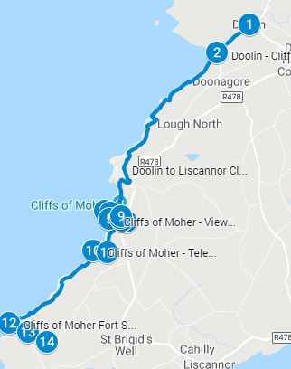
Use the Cliffs of Moher map below and the walking tour attractions guide for top things to do. A complete guide to viewing sites, parking entrances, and walking routes. Follow the walking route to explore Cliffs of Moher at your own pace and spend a few hours or a full day at each of the Top Attractions. Choose the viewing points and entrances based on your personal preference to create your own private walking tour. Click on the arrow icon to the left of the title to display the legend with additional information, images and videos. Click on the attractions map pins (blue pins) on the interactive Cliffs of Moher Map below, or on the legend or the PDF Cliffs of Moher tourist map that you download for additional information including images of the attractions
Accompanying attractions guide is HERE
Instructions to download the Interactive Cliffs of Moher map to a smartphone are at the end of the post. Click on the map pins for additional information, images and/or videos
This post contains affiliate links. That means that I may earn a commission if you make a purchase though one of these links.
To download the PDF of the Cliffs of Moher Map click HERE
Additional Tours
Book one of the popular tours and cruises available including Galway, Cliffs of Mohr, The Burren and Aran Islands. There are a number of pickup locations include locations such as Limerick, Dublin, Cork and Galway.
Cliffs of Moher Legends
1. Leap of Foals
Before Christianity came to Ireland in the form of St Patrick, it is said that the Irish worshiped Celtic deities, the Tuatha de Danan pronounced (pronounced Thoo-a day Du-non) meaning “Tribe of Danu”. Scholars have surmised that Danu was most likely the name of their Goddess Anann or Anu. They were god-like people with magical powers looked who nothing like the shorter dark skinned natives of Ireland at the time. These deities are shown in paintings as tall, red or blond haired, fair skined with blue or green eyes. Interesting that excavations of mummified bodies in China and Egypt, including Tutankhamen own grandmother, from four thousand years ago reveal the same characteristics.
Legend has it that the Dananns were upset by the advent of Christianity and turned themselves into horses. They galloped to the caves at Kilcornan. After centuries seven foals emerged from the darkness of the caves. Blinded by sunlight and disoriented they galloped over the cliff edge and into the sea. The spot where they perished is referred to as Aill Na Searrach, or The Cliff of the Foals. Today that area is the location of Ireland’s famous big wave referred to as Aileen and that attracts surfers from all over the world
2. The Moher Mermaid
The legend of the mermaid starts with a fisherman who spots a mermaid. He strikes up a conversation with her and eyes her magic cloak. He steals the cloak and goes home. The mermaid needs her cloak to go back into the sea. She follows the fisherman home in order to retrieve her cloak. However the fisherman will only return her cloak if she agrees to marry him. Not having much choice she agrees to marry him, however he does not return the cloak. Unable to find the cloak she eventually has two children with him, a son and daughter. One day while the fisherman is out at sea she finds the cloak and returns to the see never to return, leaving behind her son and daughter
3. The Lost City of Kilstiffen
According to legend if you look south towards Spanish Point (South) you will see an area where the water is disturbed. That is the location of the lost city of Klistiffen, also known as Cill Stuifin, Kilstapheen or Kilstuitheen. It was a beautiful city with golden roofs, palaces, churches. They city sank after the chieftain lost the golden key that opened the doors of an important castle in the city.
Perhaps on a calm day you can capture a glimpse of the city in a glistening sea below. The key is said to be hidden under the gravestone marked with Irish letters ‘Conan’ on Mount Callan or Slieve Callan. The area was dug out but only rusted iron and bones were discovered. It is said that once every seven years the city rises above the waves. You most likely do not want to see this event as legend has it if you witness the rising, you will die before the next rising
4. Cu Chulainn and The Hag
Cu Chulainn was a handsome warrior in the King of Ulster’s warrior branch called the “Red Branch”. A hag named Mal fell in love with him and followed him everywhere. The definition of hag is an “ugly old woman” or witch. Continually escaping from her, he ended up at the south end of the Cliffs of Moher. Here, he jumped to an island known as Diarmuid and Grainne’s Rock. Mal followed him and jumped to the island as well, helped by a gust of wind which carried her to the island. Unfortunately she did not have the benefit of the wind gust on her jump back to the cliffs and she fell against the rocks. The bay turned red with her blood and is known as Malbay. The rocks she crashed against are called Hags’s Head and take the shape of a women, presumably Mal, looking out at sea
Getting to Cliffs of Moher
Bus Éireann route #350 provides public transport to the Cliffs of Moher. You can catch the bus from the main bus stations from Ennis, Ennistymon, Doolin, Lisdoonvarna, Kinvara and Galway (Eyers Square). Ther are a number of journeys each day for bus #350. Make sure you catch the bus going in the correct direction towards the Cliffs of Moher . You will be dropped off at the Cliffs of Moher visitor center. The stop you get off at is County Clare Cliffs of Moher Car Gate
Use this journey planner, it’s very helpful in planning your trip using public transport
Are the Cliffs of Moher Free
Because of Ireland’s “Ancient Right of Way”, the public is granted free access along a certain route over private land in order to access public areas. The Cliffs of Moher Coastal Walk falls under that ancient right of ways. As such the Cliffs of Moher Coastal Walk along the cliff edge is free however you will have to pay for parking on a farmer’s private land or at the Cliffs of Moher Visitors Center. If you access the Cliffs via public transportation or the shuttle bus you will have to pay for transportation but not to access the cliffs or walk along the cliff tops
Cliffs of Moher Filming Locations
1. Harry Potter and the Half Blood Prince
This is the scene where Harry and Professor Dumbledore travel to a cave to find Voldemorts Horcruxes. They stand on a rock with the sea cliffs in the background. The cave scene was shot at one of the caves in the Cliffs of Moher. However the rock they stood on is called Lemon Rock and is 150 km south of the Cliffs of Moher and is part of the Skelligs. Youtube of the scene on the Cliffs of Moher Map above, item 12
2. The Princess Bride
The Cliffs of Moher scene in the princess bride helped to increase the tourist population at the Cliffs in after its release in 1987. In the scene, Buttercup is abducted before the wedding by Vizzini and the swordsman Inigo Montoya as well as Fezzig. She is taken by boat across Black Park Lake, and after fighting the shrieking eels, arrives at the ‘Cliffs of Insanity’ (Cliffs of Moher). In the scene you can see them scaling the cliff walls and cutting the line when they are followed. The scene involved one stuntman in a winch suspended 200 feet in the air, pretty scary!
- Youtube of the scene on the Cliffs of Moher Map above, item 3. Click on the Map pin #3
3. TV Series Father Ted
The Cliffs of Moher are in the episode ‘Tentacles of Doom’. In the scene at “The Holy Stone of Clonrichert” you see Father Jack in a wheelchair with his back to the cliffs. His wheelchair then rolls backwards over the edge of the cliffs.
- Youtube of the episode on the Cliffs of Moher Map item 3 above. Click on the Map pin #6
Click on image of map for Cliffs of Moher attractions guides
Additional Attractions in Ireland
- Getting around Ireland – Using Public Transportation in Ireland
- Cliffs of Moher – A very popular tour, a complete guide to the 16 attractions along the Cliffs of Moher Coastal Walk
- Doolin – A quaint popular village in County Clare. Stop overnight and walk to the Cliffs of Moher from Doolin or enjoy the many other attractions in and around Doolin
- The Ring of Kerry – A spectacular 111 mile scenic route on the Iveragh Peninsula. Start at either Kenmare or Killarney for a circular route of three hours without stops. Jaw dropping views of the Atlantic ocean, charming villages and wild sweeping mountains makes this a popular must see attraction in Ireland. Use the map and attractions for the complete self guided tour of the Ring of Kerry
- The Dingle Peninsula – It is a 30 mile long clockwise loop that takes about 4 hours to complete. The area is the bedrock of Irish culture with signs in many villages and towns indicating that Irish is the predominant language in the area. The picturesque landscape includes rolling hills, craggy shorelines and sandy beaches. The PDF map and attractions guide explores the attractions of the Dingle Peninsula
- The Ring of Beara – An 85 mile circular route, similar to Ring of Kerry and Dingle Peninsula, however it is far less travelled. In that sense, it is a better drive as there are far less cars on the road. I found the Ring of Beara far more dramatic than either the Ring of Kerry or the Dingle Peninsula. It is not as popular because the tourist buses are not able to navigate the narrow roads with hairpin bends or the Healey Pass.
- Dublin: Explore central Dublin on foot with these three self guided walking tours and map:
- Dublin Walk 1 – Top 18 Attractions, guide to Dublin City Center, North of the River Liffey Dublin
- Dublin Walk 2 – Top 16 attractions, guide to attractions South of the River Liffey, including the Temple Bar Region
- The Book of Kells and Trinity College in Dublin. Trinity College is the oldest university in Ireland with the historic Long Room,and the old library with over 200,000 of the very old books. It is the most impressive library in the world
- In Dublin visit the Little Museum of Dublin, Grafton Street, St Stephens Green and Kilmainham Goal (the prison where many rebels from the Easter Rising were held before their execution)
- Dublin Walk 3 – Top 16 attractions, guide to Historic Old Dublin
- Galway – Use the Galway Ireland guide for a flexible and personal tour of over 40 attractions Galway City
- Aran Islands – For a truly authentic Irish experience visit the Aran Islands. They are located at the mouth of Galway Bay. You can catch a ferry from either Doolin or Rosseeval port (Shuttle from Galway to Rosseeval ferry port)
- The Glens of Antrim – Driving route for the nine Glens of Antrim in Northern Ireland. The guide includes options for public transportation, walking trails in The Glens and Game of Thrones Attractions
- Over 100 Northern Ireland Attractions – Visit over 100 attractions along the east and north coast of Ireland along the Antrim and Causeway Coastal Route. Travel by car or public transport from the Mourne Mountains to Londonderry. Includes game of thrones sites, castles and walks along the route
- The Burren – Explore the karst moonscape bedrock of The Burren located in the southwest region and close to the Cliffs of Moher. Attractions in the Burren include ancient tombs, underground caves, walks on an unusual landscape and The Burren National Park
Instructions to download the interactive map to a smart phone:
Take the Map with you when you travel:
Instructions on:
- Using it offline
- Using it online – We bring one of our older smart phones when we travel and buy a local SIM card. You can purchase a local tourist SIM card from one of the main local providers, they are usually pretty inexpensive. You may need your passport to purchase as its a tourist SIM if you are an international tourist. You should have them put it in your old smartphone and check that it works before leaving the store. Use it to follow the map online, its the best way to explore
Sign into google using your Gmail account on your smart phone and be connected to the internet. If you do not sign in, this process will not work. You will be downloading this map to save it. You will be saving it in google maps in two places:
- Save in “Your Places” for online use and
- Save in “Offline map” for offline use
- Youtube instructions on link as follows:
https://youtu.be/_6j9koieMsU
Instructions to save above map:
- Click on the rectangle on the top right hand side of the above map [ ] – if you move your mouse to it, it will say “view larger map”
- It will take you into google maps on your smartphone and it will automatically save this map. You must be already be signed into google maps with your Gmail account, if you are not signed into google maps then the map will not be saved
- In google maps, click on the menu which is the three horizontal lines on the top left of the google map (it is to the left of the search box)
- From the menu, click on “Your Places”. This will take you to another screen with a menu at the top. From the top menu bar select “maps”. A list of your maps will be displayed including the map that was just saved. Select the map you just saved
- Make sure the map is still onscreen; do not close out of it as you will be downloading this map and it has to be onscreen to download. While the map is onscreen, click on menu again (three horizontal lines top left hand corner)
- Select “Offline maps” then select “custom map”
- Once you select “custom map”, the onscreen map will be displayed; select the area you want downloaded (zoom in or out to get all the data points into the blue square outline; pinch fingers for zooming)
- Click on “download” – this will save the map in an offline area that you can use when you are not connected to the internet
The map is now saved in two places. To see this, click on the menu (three horizontal line on top right hand corner) in google maps:
- Click on “Your Places” from the menu, then select “Custom Map”. The map will be listed and you can use the map while connected to the internet
- Click on “Offline Maps” from the menu. The map will be listed to use the map offline ie: not connected to the internet (make sure location services is turned on and your will see the blue dot indicating your location as you navigate with the offline map)
- After you download a map, use the Google Maps app just like you normally would. If your Internet connection is slow or absent, or if you are in “airplane mode” Google Maps will automatically use your offline maps to give you directions