
Use the Rome google map below to visit the attractions in the historic city center. The map is a complete self guided Rome walking tour map and guide to historic Rome attractions, including Towers, Squares, and Cathedrals. Follow the walking route on the interactive map to explore Rome at your own place. Spend a few hours or a full day depending on how long you want to spend at each attraction.
Click on the arrow icon to the left of the title to display the legend. Click on the Rome attractions map pins (green, red, brown, purple or blue pins) or on the legend (left icon on the title bar) or the PDF map that you download for additional information including images of the attractions. Each set of colored map pins can be used as a separate walking self guided route making it flexible to work into your schedule of other planned events or lunch breaks
For accompanying Rome attractions guide click HERE
To download PDF of Rome attractions map click HERE
Click on image of map for Rome Attractions Guide
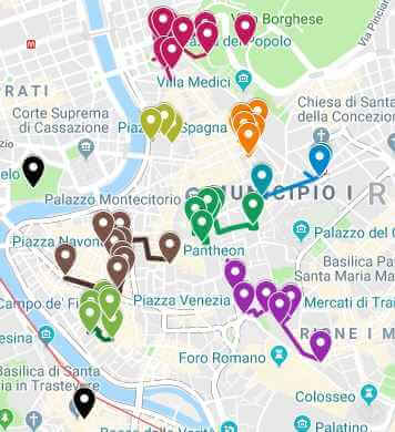
Interactive Rome Walking Tour map for as follows:
Each separate color on the interactive Rome Walking tour represents a different area in historic Rome. You can complete the self guided walking tour in one day or spread it over several days depending on the area of historic Rome you want to explore.
- Rome Walking Tour 1:The burgundy (dark red) colored Rome map on the interactive attractions map are attractions centered around Piazza del Popolo. Piazza del Popolo means “People Square” and the square takes its name from the Santa Maria del Popolo church. This church is located in the northeast section of the piazza
- Piazza del Popolo can be accessed by taking Metro line A and exiting at Flamino station. Explore Piazza del Popolo then climb the stairs to the Pincio Hill garden. From here, the Borghese Gardens are a 10 minute walk. Villa Borghese is immense and has nine different entry points (including from the top of the Spanish steps).
- Rome Walking Tour 2: In dark grey color on the interactive attractions map above you will find attractions in the area of the Villa Borghese Gardens. The gardens are 80 hectares of beautifully landscaped park. There are numerous walking trails including options to rent a bike. Stop by at one of the cafes for lunch or have a picnic in the designated areas. Attractions include Villa Giulia, Museo Carlo Bilotti, Borghese Gallery and Museum, Shakespeare Globe Theater , the Water Clock and countless statutes, sculptures, squares, and Bioparco di Roma Zoo
- Rome Walking Tour 3: The orange colored attractions map is centered on the Spanish Steps. On the interactive map, attractions are located around the Spanish Steps (Piazza di Spagna). In this are of historic Rome, there several attractions including the famous Spanish Steps leading to the grand palace Palazzo di Montecitorio, the famous Spanish Steps, and the popular Barcaccia Fountain. The Piazza Mignanelli is located next to the Piazza di Spagna.
- Rome Walking Tour 4: The Lime (light green) attractions map has attractions related to the Emperor Augustus. This includes the Emperor Augustus Mausoleum and the intricately carved Altar
- From the Monuments of Emperor Augustus, it is a quick walk to Piazza Barberini, your next stop on the Rome attractions map. This is indicated by the color blue on the interactive map. Attractions in this area include the Bernini Fountains
- Rome Walking Tour 5: The dark green on the interactive attractions map of Rome is the area in and around the famous Trevi fountain. Attractions include the Palazzo di Montecitorio and the Temple of Hadrian
- Rome Walking Tour 6: The next set of attractions in the historic city are shown in dark brown on the interactive walking tour of historic Rome. Here you will find the Piazza Navorone, a public open space and what was the home of the Stadium of Domitan. Attractions such as the fountains, statutes and palaces are located in this square
- Rome Walking Tour 7: The light green walking tour on the interactive map is the Piazza Campo de’Fiore. Campo de’ Fiori means “field of flowers” and describes how the landscape looked in the middle ages. The Piazza is just south of Piazza Navarone. In ancient Rome this land was undeveloped and eventually the Santa Brigida Church was built. Just south of the square the Palazzo Farnese was constructed. The palace was an imposing Italian palace when it was built for the prominent Farnese family in the 16th centaury. Eventually the square itself became the commercial center of Rome and the streets were named after the trades such as Via dei Baullari (coffer-makers), Via dei Balestrari (crossbow-makers), Via dei Giubbonari (tailors), Via dei Cappellari (hat-makers), and Via dei Chiavari (key-makers).
- From Campo de’Fiore” head over to Largo di Torre Argentin. Largo di Torre Argentin is a square that includes a Square with Porticos. Colonnades, Curia, Roman Temples, the remains of Pompey’s theater and the place where Julius Caesar was murdered. He was assassinated in the Curia of Pompey. Excavation of this area began in 1929
- Rome Walking Tour 8: The next stop on the Rome Walking tour is the attractions around the historic center of the ancient City of Rome. Attractions include Trajan’s Column, Trajan’s Market and Trajan’s Form. In the area is Palazzo Napoleon’s including the apartment he occupied while in Rome
Additional Rome Walking Tours:
- Self guided tour 9 will take you to the Roman Colosseum. Click on the Roman Colosseum attractions map HERE and accompanying Colosseum attractions guide HERE
- Rome attractions map and self guided tour 10 includes the Vatican City attractions map HERE and the Vatican attractions guide HERE
- Self Guided Walking tour 11, explore the neighborhood of Trastevere with map of attractions HERE and guide of attractions HERE
- The 12th walking tour is of St Peters Basilica. Explore all the attractions in St Peter’s Basilica with the attractions guide HERE
- One of my favorite trips is that of the Roman Forum and Palatine Hill. The map of attractions is HERE and the self guided walking tour is HERE
- Self Guided Walking Tours – Day Trips from Rome (Walking Tour 14 & 15)
Instructions to download the interactive map to a smart phone:
Take the Map with you when you travel:
Instructions on:
- Using it offline
- Using it online – We bring one of our older smart phones when we travel and buy a local SIM card. You can purchase a local tourist SIM card from one of the main local providers, they are usually pretty inexpensive. You may need your passport to purchase as its a tourist SIM if you are an international tourist. You should have them put it in your old smartphone and check that it works before leaving the store. Use it to follow the map online, its the best way to explore
Sign into google using your Gmail account on your smart phone and be connected to the internet. If you do not sign in, this process will not work. You will be downloading this map to save it. You will be saving it in google maps in two places:
- Save in “Your Places” for online use and
- Save in “Offline map” for offline use
- Youtube instructions on link as follows:
https://youtu.be/_6j9koieMsU
Instructions to save above map:
- Click on the rectangle on the top right hand side of the above map [ ] – if you move your mouse to it, it will say “view larger map”
- It will take you into google maps on your smartphone and it will automatically save this map. You must be already be signed into google maps with your Gmail account, if you are not signed into google maps then the map will not be saved
- In google maps, click on the menu which is the three horizontal lines on the top left of the google map (it is to the left of the search box)
- From the menu, click on “Your Places”. This will take you to another screen with a menu at the top. From the top menu bar select “maps”. A list of your maps will be displayed including the map that was just saved. Select the map you just saved
- Make sure the map is still onscreen; do not close out of it as you will be downloading this map and it has to be onscreen to download. While the map is onscreen, click on menu again (three horizontal lines top left hand corner)
- Select “Offline maps” then select “custom map”
- Once you select “custom map”, the onscreen map will be displayed; select the area you want downloaded (zoom in or out to get all the data points into the blue square outline; pinch fingers for zooming)
- Click on “download” – this will save the map in an offline area that you can use when you are not connected to the internet
The map is now saved in two places. To see this, click on the menu (three horizontal line on top right hand corner) in google maps:
- Click on “Your Places” from the menu, then select “Custom Map”. The map will be listed and you can use the map while connected to the internet
- Click on “Offline Maps” from the menu. The map will be listed to use the map offline ie: not connected to the internet (make sure location services is turned on and your will see the blue dot indicating your location as you navigate with the offline map)
- After you download a map, use the Google Maps app just like you normally would. If your Internet connection is slow or absent, or if you are in “airplane mode” Google Maps will automatically use your offline maps to give you directions