50 Popular Attractions on using the Dublin Attractions Map and guide. Three Dublin Self Guided Walking Tour
Old Dublin Self Guided Tour Walk 3 – Top 16 attractions, guide to Historic Area
- Dublin Attractions Map Walk 1 – Top 18 Attractions, guide to Dublin City Center, North of the River Liffey Dublin, Click HERE
- Dublin Attractions Map Walk 2 – Top 16 attractions, guide to attractions south of the River Liffey, including the Temple Bar Region just, Click HERE
Use the Dublin google map below to visit the attractions in historic central Dublin. A complete Dublin self guided tour map and guide to attractions, including Cathedrals, City Gates and Fortified Walls and historic Viking Settlements. Follow the walking route in orange below, to explore the city at your own place. Spend a few hours or two days depending on how you want to complete all three walking tours and how long you want to spend at each attraction. There are three separate walking tours: Tour 1- Downtown Central Dublin located north of River Liffey, Tour 2 – Temple Bar Region, St Stephens Green and Grafton Street located south of River Liffey and Tour 3 – Historic Dublin includes Dublin Corporation, Dublin City Hall (and includes parts of the Temple Bar Region)
Dublin Self Guided Tour 3 – Start at the Molly Malone Statue. Break at the end of the walk in the Temple Bar Region for a well earned pint
Download the INTERACTIVE Dublin Attractions Map HERE
Download the PDF Dublin Attractions Map HERE
Start Dublin Attractions Map Walking Tour 3
1. City Hall – Dublin Corporation
The current city hall was originally the location of the Royal Exchange. The building was completed in 1779. For additional information including history, opening hours and admission, click HERE
2. Dublin Attractions Map Medieval Quarter – Dublin Castle
In 1204, on the orders of King John of England, Dublin Castle was built by the dark pool (“Dubh Linn”) which gave Dublin its name. Completed in 1230, it had a central court and defensive walls with towers at each corner. The ancient river Poddle drained into the Liffey. It also surrounded two sides of the castle acting as a natural moat. Today the river paddle flowers under the castle complex. The castle has had many purposes over the years. It was the site of a prison, the treasury, a military fortress, a courthouse and the seat of English Administration.
The castle has had severe damage over the centuries and subsequent massive made in the 17th, 18th, 19th and 20th centuries. Today it is used for State events including receptions and Presidential Inaugurations.
On the southern side of the buildings are state apartments including St Patrick’s reception hall, throne room, state drawing rooms, state dining rooms, state bedrooms and state corridors
Of the many towers only two survive today: the records tower and the Bermingham tower
3. Medieval Quarter of Dublin Attractions Map – St Patrick’s Cathedral
Saint Patrick is credited with bringing Christianity to Ireland; it is the National Cathedral of the Church of Ireland. The 800 year old medieval Cathedral is said to be the location of a well St Patrick used to baptize converts to Christianity. The original 5th century wooden church was elevated to the status of Cathedral in 1191 and a stone church was built in its place. St Patricks Cathedral is the largest and tallest Church in Ireland. There is a small fee to enter which supports maintenance of the church however, services are free of charge to attend. Renovations have been gone on throughout its history including a major renovation to prevent its collapse, funded by the Guinness family in the 19th century.
Several facts related to the Dublin Attractions Map at St Patrick’s cathedral?
- About 700 people are buried onsite including
- Jonathan Swift, author of Gulliver’s Travel and the Dean from 1713-1745
- Richard Boyle, the first Earl of Cork,
- The Duke of Shomberg, killed in 1690 at the Battle of the Boyne. He was the 2nd in command to King William
- Robert Boyle, who discovered “Boyles Law”
- Archbishop of Dublin, Fulk De Saundford, the first person to be buried at the Cathedral
- Lord Lisburne, the grandson of the dean of the Cathedral, Adam Loftus, he was killed by a cannonball in the Siege of Limerick. Coincidentally the cannon ball that killed him hangs on the wall of the Choir, also marking his burial location
- The Great Boyle Monument of 1632, Richard Boyle and his 2nd wife Lady Catherine
- A stone statue of St Patrick, the body is from the 13th century, the head from the 14th century and the base is from the 19th century
- The Great Door – legend has it that the Butlers of Ormonde and the Fitzgerald’s of Kildare were in the middle of negotiating a “peace contract”. As a sign of good faith, Gerald Fitzgerald put his arm through the hole in the door in the hope of getting a handshake rather having his arm cutoff. The two families shook hands and made peace
- Oliver Cromwell, held court martials in the Cathedral in 1651 and also used the nave to stable his horses showing a lack of respect for the Anglican Church
- The Orange chair used by King William at a service in the cathedral after the Battle of Boyne. The battle marked a change in the practice from Catholicism to Protestantism in Ireland
4. Dublina
One of Ireland’s best museums, with a detailed history of Medieval and Viking Settlements
5. Christ Church Cathedral, Medieval Quarter of the Dublin Attractions Map
Next on the Dublin self guided tour is Christ Church Cathedral. The Cathedral of the Holy Trinity, commonly referred to as Christ Church is one of two medieval churches in Dublin. In 1030AD the Norse King of Dublin Sitric Silkenbeard commissioned a place of Christian worship on a hilltop overlooking the Viking settlement at Wood Quay. Originally, a wooden Church for the Viking settlement, it is now an Anglican Church. In 1180AD wealthy Normans funded the rebuilding of the Church in stone, complete with choir aisles, transepts, chapels and a crypt. Since then there have been a number of renovations, restorations and expansions.
In the 17th century, the law courts and the parliament convened in a building next to Christ Church. These functions were later moved elsewhere
In the 19th century, the Cathedral had sunk into disrepair and was declared unfit for usage, Extensive repairs and renovations funded by the distiller Henry Roe and carried out by English architect George Edmund Street were completed in 1878 after 7 years of work onsite. The work cost £230,000, equivalent to about €26M today. The last renovation was in 2000 and it is open to tourists at a cost.
The renovations over the centuries starting in the middle ages has resulted in a mix of architectural styles including Gothic, Romanesque and Victorian. As you enter, the church’s breathtaking beauty opens up with a patterned Victorian tiled floor, stained glass windows, richly carved woodwork and soaring cloisters.
Today Christ Church is one of three Cathedrals in Dublin; Christ Church, St. Patrick’s and St. Mary’s. It is the location of Citizenship Services, and hosts consecrations of bishops and ordinations of priests. As you enter the Church, basic information on the church and its history is found near the entrance. Visited by over 200,000 tourists a year, tickets to see the Cathedral can be purchased with or without a tour, audio guides are also available at a cost. It is extra to see the Belfry in the upper part of the cathedral and perhaps try your hand at ringing the bells. However if you attend the weekly morning service which is open to all faiths, there is no fee. The Belfry is not accessible as part of the service
What is there to see in Christ Church, Dublin
Christ Church: Saint Laurence O’Toole’s Heart
Christ Church in the Dublin Attractions Map has several areas that you may want to spend some time viewing. St Laurence O’Toole was born Lorcán Ua Tuathail. He was the Archbishop of Dublin when the Norman’s invaded Ireland. He mediated between the parties during and after the invasion. Pope Honorius !! canonized him in 1225AD. In 1442 his skull was brought to England, his bones were interred at the St. Laurence Church in Chorley England until they disappeared during the Reformation. His heart was preserved at Christ Church in the 13th century until it was stolen in 2011. The heart was eventually recovered in Phoenix Park as the thieves believed it would bring illness to their family members. At an evensong, the heart was returned to Christ Church in April 2018
Christ Church: The Nave
In the Nave you will find the tomb of Strongbow an Anglo-Norman leader. Strongbow was the nickname of the 2nd Earl of Pembroke, Richard de Clare, Lord of Leinster. He led the Anglo-Norman involvement into Ireland. Strongbow is nicknamed “Voldemort” as a result of people rubbing his nose over the years. His nose resembles that of Harry Potters nemesis Voldemort.
Christ Church: Crypt
The crypt was built in 1173AD and is one of the largest in Britain or Ireland at 64m long. As you make your way down to the crypt, you will notice a drop in temperature as it is cooler in the crypt. In the crypt, you will find:
- Costumes from the series “The Tudors”
- The oldest know Statues, carved in the 18th century
- Ancient books
- Candlesticks and a tabernacle from when the Church was a Roman Catholic cathedral
- Mummied remains of a “Cat and the Rat” commonly referred to as “Tom and Jerry”. A cat got stuck in the tube organ while chasing a mouse, the cat inadvertently blocked the exit trapping both of them. Their mummified remains were found in 1860 and has become a popular tourist attraction
Christ Church: Stone Bridge
A stone bridge across Winetavern Street connects the cathedral to Synod hall. Synod Hall was a separate church, St Michaels; today it displays an exhibition of medieval Dublin called “Dublina”
6. Winetavern Street
This historic street in the Dublin Attractions Map could be the “historic” version of the Temple bar region. During the excavations of Wood Quay, pewter tavern tokens were found in the area dating to the 13th century, in total about 2,061 tokens were uncovered. The area was occupied by taverns and drinking establishments until the 18th century. The Dubliners came for a pint, to socialize or conduct business over a glass of wine or ale. Images of how it looked can be found on the Dublin Attractions Map (Red Route)
7. Fishamble Street
One of the oldest streets in Dublin dating back to the 14th century. If you like history, it is a must see and experience area in the Dublin Attractions Map. It was the official fish market in Dublin until the 17th century when the fish market was moved to the north bank of the Liffey River. In 1680 it was replaced with the General Post Office which stood here for 30 years, The street was the location of the famous Bulls Head Tavern from the 18th century. They Bull’s Head Musical Society which met in the Tavern, decided to build the Neal’s New Musick Hall on this street. It opened in 1741.
The entrance arch to the Hall is still located there. Neal’s Musick Hall was the location where Handel’s Messiah was first performed on April 13 1742 for charity. To accommodate the expected 700 guests, it was requested that men come without swords and women attend without hooped skirts. Handle’s Messiah is still performed today as an open air concert free to everybody. The archway became the entrance to Kennan & Sons Ltd, an engineering company, and they used the building until in 1986
8. Cook Street
As you move to the next attraction, you may see a pattern where the names of the streets in the Dublin Attractions Map appear to be named for their function. Similar to Winetavern Street, this street dates back to the 14th century and literally it was the “street of cooks” or “Vicus Cocorum”. Lined with stalls and shops selling food, it became residential when in 1535 when John Burnell, an Anglo-Norman took up residency there. Others followed him and in 1623 the Lord Mayor of Dublin lived on Cook Street. Cook Street became a refuge for Jesuit priests, monks, nuns and priests for the Dominican, Franciscan and Carmelite order. Many Dubliners were executed for housing them in their homes on Cook Street. An image of the istoric street can be found on the Dublin Attractions Map
Near Audeon’s Church on Cook Street, a portion of the medieval Dublin Wall can be seen with a restored functioning medieval gate at St Audeon’s Arch, also called St Audoens Gate. Part of the wall has been modified and restored; it stands 7 meters high, 2m wide and is 90 meters in length. Today you may be able to enter the gate and follow the narrow pathway to High Street.
As I walked these ancient cobble stone streets, I have to admit that I got a little lost looking for some of the attractions. However just wandering the street gave me a real sense of historic Dublin.
9. Wood Quay
Originally, a monastery, the Monks called the area Dubh Linn which was Gaelic for Black Pool as a large murky pool was located near the Liffery. The area became a Viking settlement in 795 AD and became their over winter camp laying the foundations for the modern city of Dublin. You can still see their encampment in Wood Quay and near the Dublin Castle. You may be able to use the images on the Dublin Attractions Map to try and map out the area.
The Viking settlement was destroyed when the Dublin City Council erected large office buildings however, the story of Dublin starts here at the Wood Quay, which is now occupied by concrete buildings of the Dublin Corporation. Though archeologists, historians and international experts tried to save the area from redevelopment, their campaign failed and in the 1980 development of the area went ahead.
The Viking settlement contained artifacts and remnants, which offered insights into life during that time. The quay was used to moor ships offloading goods. The settlement contained houses, shops, remnants of clothing, pottery, tools and craftsmanship. The Vikings were eventually driven off the land by the Irish, however soon after the Norsemen arrived led by King Sitric Gale who refounded Dublin. In 1240 they reinforced the walls built by the Vikings and peppered the barrier with a handful of gates. Not only did the wall protect Dublin, over time, it served as a tollbooth. The Norse now occupied the area. Many of these are on display at the national Museum of Ireland on Kildare Street.
The Liffey River had a natural island at its center, at low tide, Dubliners laid branches and created paths to cross the Liffey River, this was known as the “Fordes of the Hurdles”, and was the original crossing point of the Liffey River. It is very close to the current location of the Brazen Head Pub
10. Isolde’s Tower
Lower Exchange Street, Dublin 2,
In 1993, during redevelopment of Woods Quay, the lower portion of a 13th century tower was discovered. Estimated to stand at a height of 30-40 ft, it was originally discovered in the 17th century and is part of the northeast corner of the city wall defense system that surrounded the city. Most of it was destroyed and the remains eventually buried as the city grew around and over it. Part of the city wall and the Isoldes Tower still exist underground and some sections of Isodes Tower can be seen above ground, other parts were incorporated into the apartment complex of the same name. The circular foundations of Isolde’s Tower, can be seen from the street (Exchange Street Lower), hidden behind an iron grill
11. Old Dublin City Walls – Medieval Dublin
Dublin was established over a 1000 years ago from the merging of two small Christian settlements of “the Fordes of the Hurdles” and Dublh linn – the “Black Pool” under Viking and Norsemen control.
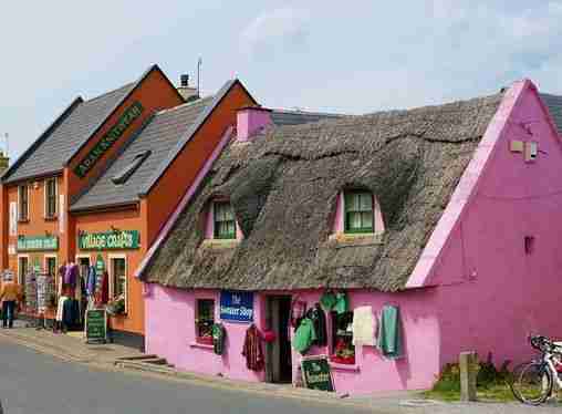
12. There are several attraction in the Dublin Attractions Map for the Temple Bar Area
The Templar bar area is seen as the cultural hub if central Ireland. A small area in a few blocks with bars, boutiques, restaurants, galleries, pubs accessed by narrow wandering streets lined with buskars, vendors and open air markets. In medieval times, it was known as St Andrew’s Parish and located outside of the Dublin City Walls, Attacks by the native Irish resulted in St Andrews parish falling into disrepair and eventually disuse.
In the early 1600’s Sir William Temple built a home and garden in the area and the area got its name from the Temple Family when he became Provost to Trinity College from 1609 to 1627. The area was redeveloped from marshy lands bordering the Liffey River to create homes and gardens for wealthy English families where the gardens ran down to the water’s edge. Sir Williams’ son, Sir John Temple was instrumental in building a “sea wall” in 1656 to prevent the Liffey River from flooding into the homes and gardens. The area became known as Temple’s Barr (where a Barr was a raised sandbank that you could walk on)
In 1707, a customs house was established in the area, where the Clarence Hotel Stands. This attracted warehouses, taverns and brothels. In the 18th century, the area continued its decline and was the location of ill repute and prostitution. The decline continued into the 19th century. In 1991 the government rejuvenation of Templar Bar started with the creation of the Temple Bar Properties, a government nonprofit organization with the aim of establishing the area as Dublin’s Cultural Quarter
The Temple Bar Pub
Stop by the Temple Bar on the Dublin self guided tour. It is one of the most famous pubs in Ireland, its red exterior is distinct and attracts tourists from all over the world. Operating since 1840, it has Ireland’s largest collection of rare whiskey on display, 450 bottles in all
This might be a good time to take a break and continue the Dublin self guided tour after a well deserved pint at one of the local pubs
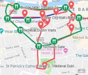
13. Gates of Dublin – It is difficult to find all of these, a list of potential locations are on the Dublin Attractions Map
The city was protected by a fortified wall system, access into the city was through several well guarded gates. The wall and gates were refortified in 1240 by the Norman settlers. These can be seen on the Dublin Attractions map (green route)
- Dames Gate – May have included Isolde’s Tower and was built in 1305, corner of Dame Street and Palace Street on google maps. It was the narrowest entry into the city Street and you can still see remnants of the gate
- Pole Gate, also known as St Werburgh’s Gate – It was located at the corner of Werburgh Street and Ship Street Little, southern end Werburgh Street
- Nicholas gate is south of New Gate – located at the corner of Nicholas Street at St Nicholas Place between Ross Road and Bride Road. There are no remnants for the three story high gate, just an unpaved alleyway
- Gormonds Gate – at the end of St Augustine Street , intersection of St Augustine Street and Wormwood gate on google map. Named after Willian Gormond who lived at the location in 1233
- Bridge/Osmans Gate – Protected the city from the River Liffey crossing at Bridge Street. It is on the corner of Bridge and Merchants Quay on google maps. There are no remnants of the gate
- Audeons Gate – called “Dublin City Gate” in google map. One of the most well preserved gates that has survived; it is located behind the side of the Audoen’s church and leads to a narrow alley. Today, it can be used to exist the historic city center to High Street
- New Gate – end of High Street, west of St Audoen’s church on the map (depicted by a gate symbol), Called “Old Dublin city wall” on google map. In 1485 the city jail, Newgate Prison, was established and became part of the gate structure
After the Walk – Might be a good time to take a break – Temple bar Region. Continue on to additional attractions below
Additional Popular Attractions in Dublin:
14. Guinness Storehouse
The brewery was founded by Sir Arthur Guinness in 1759 when he signed a lease for 9,000 years. The Irish’s love for Guinness is great that the brewery expanded to the point that it had its own giant gate across St James Street, giving the brewery its official name St James Gate Brewery. By 1930, 5000 people worked there, however automation has resulted in an employee population of about 600 people who produce 2.5M pints of beer EVERY DAY!!
The seven story building including a pint shaped atrium, is dedicated to the art of making and enjoying Guinness and welcoms 20M visitors a year. The building contains a museum with interactive exhibits, a tasting room, a retail store, a restaurant, a rooftop Gravity Bar with a spectacular view of Dublin city and a copy of the 9,000-year lease displayed in the atrium. Tickets can be purchased online at their website or at the entrance
15. Pearse Lyons whisky distillery
Owned by the founder of Alltech, an agriculture giant, the boutique distillery is located in a historic neighborhood that Pease and his father and grandfather grew up. In fact, Pearse’s first job was at the Paddy, Powers and Jameson Whisky distillery. The Pearse Lyons whisky distillery is in the restored St James Church located in the oldest city neighbourhood known as The Liberties. The painstaking renovation of the dilapidated 12th century church has been designated as a national monument.
Tour of the distillery includes:
- A history of the area and of St James Church
- Stories of the individuals buried in the Church cemetery
- A tour of the distilling process
- Whisky tasting
16. Jameson Distillery Bow St, St James distillery
The distillery was established in 1780 by John Jameson and expanded in 1805. It fell into difficult times during the American Prohibition, Ireland’s trade war with Great Britain and the advent of Scotch blended whisky. Jameson rebranded itself as the Irish Distillers Group in 1966 by partnering with Cork Distillers and John Powers & Sons and was one of the last distillers in Ireland to close in 1971. Today the distilling operation has moved out of Dublin to County Cork and is a subsidiary of Pernod Richard
The Distillery on Bow St is now a visitor’s center, it provides whisky tastings, guided tours, a gift shop and a bar
Queen of Tarts
If you’re on the lookout for some good coffee and even better cakes, then the Queen of Tarts on Dame Street. The caffe founded by NYC pastry chefs trained sisters Regina and Yvonne Fallon. They offer generous and delicious portions of sweet treats across two locations in Dublin since the late 1990s. This is the perfect rest stop in the middle of the Dublin Walking Tours
Additional Ireland Attraction Guides:
- Getting around Ireland – Using Public Transportation in Ireland
- Cliffs of Moher – A very popular tour, a complete guide to the 16 attractions along the Cliffs of Moher Coastal Walk
- Doolin – A quaint popular village in County Clare. Stop overnight and walk to the Cliffs of Moher from Doolin or enjoy the many other attractions in and around Doolin
- The Ring of Kerry – A spectacular 111 mile scenic route on the Iveragh Peninsula. Start at either Kenmare or Killarney for a circular route of three hours without stops. Jaw dropping views of the Atlantic ocean, charming villages and wild sweeping mountains makes this a popular must see attraction in Ireland. Use the map and attractions for the complete self guided tour of the Ring of Kerry
- The Dingle Peninsula – It is a 30 mile long clockwise loop that takes about 4 hours to complete. The area is the bedrock of Irish culture with signs in many villages and towns indicating that Irish is the predominant language in the area. The picturesque landscape includes rolling hills, craggy shorelines and sandy beaches. The PDF map and attractions guide explores the attractions of the Dingle Peninsula
- The Ring of Beara – An 85 mile circular route, similar to Ring of Kerry and Dingle Peninsula, however it is far less travelled. In that sense, it is a better drive as there are far less cars on the road. I found the Ring of Beara far more dramatic than either the Ring of Kerry or the Dingle Peninsula. It is not as popular because the tourist buses are not able to navigate the narrow roads with hairpin bends or the Healey Pass.
- Dublin: Explore central Dublin on foot with these three self guided walking tours and map:
- Dublin Walk 1 – Top 18 Attractions, guide to Dublin City Center, North of the River Liffey Dublin
- Dublin Walk 2 – Top 16 attractions, guide to attractions South of the River Liffey, including the Temple Bar Region
- The Book of Kells and Trinity College in Dublin. Trinity College is the oldest university in Ireland with the historic Long Room,and the old library with over 200,000 of the very old books. It is the most impressive library in the world
- In Dublin visit the Little Museum of Dublin, Grafton Street, St Stephens Green and Kilmainham Goal (the prison where many rebels from the Easter Rising were held before their execution)
- Dublin Walk 3 – Top 16 attractions, guide to Historic Old Dublin
- Galway – Use the Galway Ireland guide for a flexible and personal tour of over 40 attractions Galway City
- Aran Islands – For a truly authentic Irish experience visit the Aran Islands. They are located at the mouth of Galway Bay. You can catch a ferry from either Doolin or Rosseeval port (Shuttle from Galway to Rosseeval ferry port)
- The Glens of Antrim – Driving route for the nine Glens of Antrim in Northern Ireland. The guide includes options for public transportation, walking trails in The Glens and Game of Thrones Attractions
- Over 100 Northern Ireland Attractions – Visit over 100 attractions along the east and north coast of Ireland along the Antrim and Causeway Coastal Route. Travel by car or public transport from the Mourne Mountains to Londonderry. Includes game of thrones sites, castles and walks along the route
- The Burren – Explore the karst moonscape bedrock of The Burren located in the southwest region and close to the Cliffs of Moher. Attractions in the Burren include ancient tombs, underground caves, walks on an unusual landscape and The Burren National Park