Use the Self Guided Tour and Map Below to Visit over 40 Attractions in the 9 Glens of Antrim
The perfect Irish road trip with hikes in the Glens of Antrim, Walking Tours and Ireland’s Game of Thrones Film Locations
What are the 9 Glens of Antrim
The 9 Glens of Antrim, referred to by locals as “The Glens” are nine glacier carved glens that radiate from the Antrim Plateau to the Sea, in the County of Antrim, Northern Ireland. Bewitching landscapes that include lush wooded forests, miles of grasslands, golden sandy beaches, vertical rocky cliffs, waterfalls, craggy shorelines and captivating charming villages. The 9 Glens of Antrim are a unique formation in Northern Ireland where you could easily spend a week exploring the beauty of “The Glens”
Use the 9 Glens of Antrim map for the most complete Irish road trip to explore the various glens: there are Game of Thrones locations, quaint villages, hiking to waterfalls, cliffs, forests and golden sandy beaches. Stay at one of the charming villages and explore the 9 Glens of Antrim sites. In this article, you will find self-guided hiking maps, to walks along the shore, to waterfalls, nature walks, forest walks and cliff walks. Drive to the locations and explore each area or use this trip planner to plan an Irish road trip by taking the local bus. The 9 Glens of Antrim are a must visit and an often overlooked tourist spot in Northern Ireland
Where are the 9 Glens of Antrim
The Glens are found along the Causeway Coastal Road starting about 10 miles north of the village of Larne. As you travel north from Larne on the Causeway Coastal route The Glens (see the map of the 9 Glens of Antrim) in order from south to north they are:
- Glenarm – meaning glen or valley of the army
- Glencloy – glen or valley of the sword
- Glenariff – glen or valley of the plough
- Glenballyeamon – glen or valleyEdwardstown
- Glenaan – glen or valley of the little fords
- Glencorp – glen or valley of the dead
- Glendun – brown glen or valley OR glen or valley of the Dun (river)
- Glenshesk – the sedgy (reed) glen OR barren glen or valley
- Glentaisie – named after Princess Taisie of Rathlin Island, Taise’s valley or glen
A summary highlighting the varied landscape and beauty of the 9 Glens of Antrim along the Antrim Coast
Click HERE to download the Irish road trip INTERACTIVE map in the 9 Glens of Antrim to your smart phone
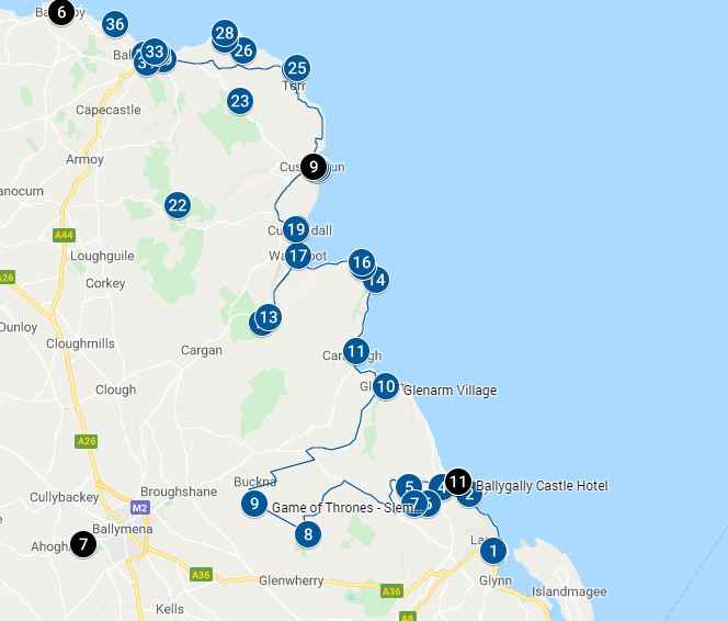
Click HERE to download the 9 Glens of Antrim Irish Road Trip PDF Map in Northern Ireland
Click on the map pins for additional information including images, videos of the specific attraction as well as the Game of Thrones Scenes
How to Use The Glens Map for your self guided Irish road trip in the Glens of Antrim Tour
The Glens attractions guide is below. Use the guide with the map above and follow the directions to the various sites and attractions. The numbered items on the 9 Glens of Antrim Map (interactive map and PDF map) correspond with the numbered items in the guide below. If you cannot download the map, simply input the destinations on google maps and it will guide you to the next destination
Start of Irish Road Trip and Self Guided Tour of the 9 Glens of Antrim (items 1 – 40)
1. Larne, the first stop on the Irish road trip
Larne is a deep harbour seaport town 20 miles from Belfast on the east coast of Northern Ireland with a population of just under 20,000. It is believed to be one of the earliest inhabited areas in Ireland with discoveries of artifacts dating back to 6000BC. Early settlers arrived from Scotland and developed a trading route between Ireland and Scotland at the Larne harbour
Over the course of its history, it has been occupied by the Vikings in the 10th and 11th century, the Scottish Clan in the 13th century and later, the Bissett’s who built Olderfleet Castle at Curran Point in Larne Harbour. The King of Scotland’s brother, Robert the Bruce arrived at Larne in 1315 to attempt to conquer Ireland. Later on in the 18th century, it was the point of emigration to America
The trading activities in Larne have dramatically increased; the harbour’s phenomenal growth makes it the 2nd largest harbour in Northern Ireland dealing with over £370million worth of goods per annum
Hike Ireland / Walking Tours Ireland (The Glens of Antrim Walks):
- 2. Carnfunnock Walks – (Number 2 on interactive or PDF map). Four walks from 0.8 to 2.5 miles in Carnfunnock, near Ballygalley
Glens of Antrim: Glenarm
Glenarm is the first of the 9 glens of Antrim on your Irish road trip. In the glen/valley of Glenarm you will find the villages of Ballygally, Carincastle and the seaside village of Glenarm. Located north of the coastal in the Glens of Antrim County
3. Ballygally Castle
This is my favorite lunch stop on the Irish road trip. We usually stop at the Ballygally castle for lunch and parked in the castle parking lot right next to the shore. The castle was built by James Shaw in 1625. It was sold by his descendants in the 1799 to entrepreneur Cyril Lord. His descendants eventually sold it to the Hastings Hotel group in the 1950’s at which time the property underwent extensive renovations including expansion of the castle.
Ballygally Castle is said to be the most haunted castle in Ulster and the only 17th century building used as a residence in Northern Ireland. The areas is said to be haunted by Lady Isobel Shaw. Unable to produce a make heir, she was locked in her room by her husband James. In her attempt to flee with her baby girl, she either fell or was pushed from the tower window about 400 years ago. Book the Ghost room at the castle if you are brave enough. A word of caution, there is more than one ghost that has been sighted and mediums have been reported to say that there are more ghosts then guests at the hotel!
History Behind The Game of Thrones Doors
Some of the trees of the Game of Thrones famous Kings road, known as Dark Hedges, fell during Storm Gertrude in early 2016 coinciding with the release of Game of Thrones Season 6. A decision was made to preserve the “memory” of the trees and 10 doors were intricately carved from the fallen trees. Each door representing one episode in season 6. The 10 doors were then hung throughout Northern Ireland. Door #9, representing Episode 9, is hung at Ballygally Castle.
Ireland Game of Thrones Door 9
- Ballygally
Castle is on the Causeway Coastal route and is the home of one Game of Thrones
Door No 9. Episode 9: Battle of the
Bastards
- Carved into the door are the crests for the House of Stark and the House Bolton. You will also find the direwolves at the base of the door flanking a tortured man, perhaps foretelling a House of Stark victory; central to the door is Winterfell, the Starks ancestral home
4-9. Cairncastle (Also a Game of Thrones Film Location)
Cairncastle’s is a small village in the 9 Glens of Antrimwith a population of 66 at the 2001 census. The hills and mountains one mile behind and west of Cairncastle village were used for several Games of Thrones (GoT) scenes raising the profile of this small village. Sallagh Braes a hill with an elevation of 352 meters and Knock Dhu is a basalt mountain escarpment (an actual Bronze Age promontory fort) are found on the northern edge of the Sallagh Brae. Sallagh Braes is situated west of Cairncastle and is west of Knock Dhu (mountain). Refer to map above for location
Ireland Game of Thrones Film Location
- Cairncastle was used in several Game of Thrones Ireland locations for scene related to Winterfell, Harrenhal, Riverlands, Moat Cailin (the Neck)
- Season1, Episode 1. “Winter is Coming”. The Mountains above Cairncastle where Ned Stark executes the deserter, Will, from the Night’s Watch for desertion. This is the start of Games of Thrones series
- Season 3, Episode 7. “The Bear and the Maiden Fair”. The resting place where Jaime Lannister, after being released, stopped on the way back to Kings Landing; Qyburn tends to the stump of his lost hand.
- Season 5, Episode 3. “High Sparrow”. This is the location of Moat Cailin, where the conversation between Littlefinger (Lord Baelish) and Sansa regarding a possible alliance with the Bolton family. She then agrees to marry Ramsay Bolton The basalt outcrop is meant to represent The Neck
- Season 6, Episode 7. “The Broken Man”. Sallagh Braes is Riverlands where the Hound (Sandor Clegane ) lives a peaceful existence in a small village after denouncing his previous violent life. However everything changes when three men from the Brotherhood without Banners, murder the villagers
8. Shillanavogy Road (Also a Game of Thrones Film Location)
Ireland Game of Thrones Film Location
- Shillanavogy Valley, at the foot of the Slemish Mountain is transformed into Dothraki grasslands
- Season 1, Episode 2, “The Kingsroad” Viserys, Daenerys, and the Dothraki camp grasslands which later on became part of their Dothraki home
Click on the map pins on the interactive or pdf map above for additional information including images and videos of the specific Glens of Antrim Game of Thrones Scene
9. Slemish Mountain (Also a Game of Thrones Film Location)
The Slemish mountain is a extinct volcano that rises about 1500 ft above the plain. According to legend, the Slemish Mountains was the home of St Patrick when he was brought to Ireland as a slave for 6 years herding sheep for the local Chieftain Milchu. He was a slave from the age of 16 to 22 and it was in this peaceful and remote location where he turned to prayer. People hike to the mountains on a pilgrimage on March 17, St Patrick’s day. The hike is approximately 1.5 km to the summit and back and is steep in some locations
Hike Ireland / Walking Tours Ireland, a nice stop on your Irish road trip for a walk in the Glens of Antrim:
- Sleamish Mountain Hike – Hike to the summit and back
Ireland Game of Thrones Film Location in the Glens of Antrim
- Vaes Dokrath, the only city in the Dothraki Sea, Essos.
- Season 1, Several Episodes. The valley of Slemish Mountain is transformed into the ancient Dothraki city ofVaes Dothrak. Many of the scenes in Season 1 show the slemish mountains in the backround of the Dokrathi Grasslands
The main source of income for residents in Glenarm is farming and some income from the Northern Salmon Company and the Omya UK Ltd (Limestone)
To see and experience the scenery, where possible I have listed walks that can be taken in the area of the attractions in the article. These sites will allow you to visit the Game of Thrones scenes up close and walk the beautiful hills, cliffs, waterfalls, coastline, grasslands or forested areas in Ireland
Hike Ireland / Walking Tours Ireland (The Glens of Antrim Walks):
- Sallagh Braes Walk – A 1.8 mile walk from the Linford Car Park (Number 5 on interactive or PDF map above) to stretch your legs on the Irish road trip. This is take you along the exposed hillside, neolithic burial sites and along the edge of the Sallagh Braes basalt cliffs. Caution is urged along the Cliffside
Check the terrain, wear walking or hiking shoes, bring water and be prepared for bad weather. Walks in Northern Ireland, and specifically in the 9 Glens of Antrim bring spectacular scenery and are well worth the effort
10-11. Glenarm Village in Glens of Antrim
The next glen on your Irish road trip will take you to the village of Glenarm. Glenarm village is the home of Glenarm Castle with its associated private wooded area and demesne forming the estate of the Earl of Antrim. It is the main focal point of the Glenarm village. The castle is available for film locations and as a wedding venue. It has a tea shop and gift shop plus property to rent such as the gamekeepers cottage. The MacDonnell clan relocated to this area after the collapse of Dunluce Castle further north. The castle was the seat of the MacDonnell clan since 1750. The remains of Templeoughter Church is close by and is claimed to be the burial place of Shane O’Neill, minus his head. His head was put on a spike and displayed in Dublin Castle
Glenarm village has various walks that will take you to areas where you can explore the different landscapes of this glen including coastal walks, cliff walks and nature walks in the forest.
Hike Ireland / Walking Tours Ireland in the 9 Glens of Antrim:
- Glenarm Coastal Walk – About 1 km walk along the shore
- Glenarm Forest Walk – A great walk to see wildlife and views. Follow the yellow markers for a 0.5 mile walk along the Glenarm river, or the blue markers for the 1 mile walk and red markers for a 2 mile walk
- Glenarm Tourism – The Glenarm tourism site has a list of these walks. There are four walks around the Glenarm area
Glens of Antrim: Glencloy
The glen is in the shape of a sword that sweeps out to Carnalough and surrounded by white limestone chalk quarries. AS you enter this glen on your Irish road trip, you will notice that it has a unique and distinctive feature of a “White Arch” near the harbour and over the coast road. Mottes and mounds indicating castles or campsites such as Doonan Fort and Dungallan Fort are within walking distance of Carnalough harbour. The area was said to be a Viking stronghold. The area is rich in natural resources and an industry grew around the extraction of the limestone. The limestone was transported to the shore using an ingenious gravity based system where the weight of the loaded wagons going down would pull the empty wagons up. Remnants of the old rail system still exists along the harbour
12. Carnalough (Also a Game of Thrones Film Location)
Visit Carnalough Beach and the coastal village of Carnalough with a population of about 1000. You can see Carnalough harbour which was a film location for Game of Thrones Ireland or talk a walk from the harbour to the spectacular Cranny Falls. The harbour was built around 1850 by the Marchioness of Londonderry and used to export limestone from local quarries. Today it is used for holiday housing, boating and yachting
If you are here at New Years, join the locals for their famous New Years swim in the freezing harbour waters
The main source of income in this area comes from the tourist industry and farming
Ireland Game of Thrones Film Location in the 9 Glens of Antrim
Carnlough Harbour was used as the stone steps at the canal in the powerful Free City of Braavos on the northwest end of Essos
- Season 6, Episode 7. “The Broken Man”. Arya Stark was stabbed by the Waif and in order to escape she jumps into the freezing water and then crawls out of the Braavos canal to the top of the steps
Hike Ireland / Walking Tours Ireland (The 9 Glens of Antrim Walks):
- Carnalough Harbour to Cranny Falls – a 23 min 2.4 mile walk along the old railway system from Carnalough harbour to Cranny falls. The mesmerizing falls look like something out of a fairy tale. You can drive instead of walk and it is about a 6 min drive on a narrow road
Glens of Antrim: Glenariff
Generally referred to as the “Queen of the Glens” it is the largest of the 9 Glens of Antrim. The valley is U-Shaped with outstanding views and breathtaking waterfalls and wildlife. The glen spreads out to the coastal village of Waterfoot which lies at the foot of the glen along the causeway coastal route. If you look closely at the glen, you will notice it has been divided up for tenant farmers seen as “ladder fields”. The strips of land were long allowing each farmer equal parts of pastureland, mountain grazing and arable land. Things to do include walks, Red Bay Castle, Garron Point and the village of Galboly
13. Glenarrif Tea House, take a break from your Irish road trip
In the area is the Glenariff Tea House located at the foot of Glenariff falls. Stop by for a coffee, tea, a snack or lunch and make your way to the falls. It’s the most peaceful setting and a great place for a family reunion or an outdoor wedding. They even have a cottage for rent
14. Laragh Lodge
Laragh lodge is a teahouse built in 1890 beside the Ess-Na-Laragh (the fall of the mare) waterfall. It’s a great place for a break or a walk around to enjoy the scenery or a place to book special events. There is a licensed restaurant serving light meals such tea and scones or full meals such as fish and chips to a steak dinner
15. Garron Point
Garron Point is a headland on the Causeway Coastal route in the 9 Glens of Antrim. It is located after Carnalough and before you approach Waterfoot. It is a great place for a break in your Irish road trip. Park your car in the parking lot and take a walk along the rugged coastline or enjoy a picnic with spectacular views of the Mull of Kintyre in Scotland and Ailsa Craig Island
16-17. The Hidden Village of Galboly (Also a Game of Thrones Film Location)
Galboly is located in an isolated place up the mountain consisting of about 10 houses. Today it is in ruins with just one preserved house. To get to the closest village of Glenariff, it would have taken the villagers several hours to climb down the mountainside and along the coastline. Without electricity and plumbing life was hard for the villages as water would have been transported from the coastal area
The Game of Thrones Panel for Glaboly / Runestone is located at coordinates: 55.057528, -5.981417
Ireland Game of Thrones Film Location in the Glens of Antrim
- Location of Runestone, the Seat of House Royce in the Vale of Arryn
- Season 5, Episode 1, “The Wars to Come” This is where Robyn Arryn, Lord of the Eyrie, was raised by Lord Royce. In this episode, Sansa and Littlefinger are observing Robin’s training and his attempt at duelling
Hike Ireland / Walking Tours Ireland (The Glens of Antrim Walks):
- Galboly and Garron Plateau Walk – A steep 2 mile walk from the coast to Galboly
18. Waterfoot
Waterfoot was a Danish settlement and is a popular holiday seaside village Glens of Antrim County. Known for its reddish sand at Red Bay which washes down from the sandstone cliffs nearby. It has a population of about 520 people
Hike Ireland / Walking Tours Ireland (The Glens of Antrim Walks):
- Waterfoot Beach Walk – A 1.6 mile walk along Waterfoot Beach, with two children’s playgrounds
- Glenarrif Nature Reserve Waterfall Walk – The walk is about 1.5 miles through Glenarif Natural park, that includes a river gorge and amazing waterfalls
- Glenarrif Forest Park Viewpoint Trail – A circular 1.2 mile route starting at the café car park. It has great sea views
- Map of Glenariff Forest Park – A walking map with marked trails
20. Glens of Antrim: Glenballyeamon
The next glen on the Irish road trip is Glenballyeamon. The village of Cushendall is at the foot of Glenballyeamon located at the mouth of the river Dall where three glens meet: Glen Ballygallyeamon, Glenaan and Glencorp. Cusendall was purchased by Francis Turnly in the early 19th century after he returned from China where he made his fortune working for the East India Company. As a landlord, he expanded the town building the Curfew Tower, the Glens of Antrim Hotel and Drumnasole House. It was the first village in Ireland to have hydroelectric power in 1923 powered by the rushing water falls and street lighting in 1924. With a population of just about 2000, it is designated as Conservation Area in Northern Ireland due to the well preserved Irish Georgian Buildings on its four original streets
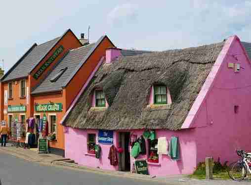
21. Cushendall
It is a quaint charming village in the 9 Glens of Antrim with pastel colored homes and the tributary of the river Dall that meanders through it. Cushandall, meaning foot of the Dall, is overlooked by the Lurigethan and Tievebulliagh mountains. It is downslope of the Trostan mountains which are the highest mountains in County Antrim. In prehistoric times, pocellanite was mined in the Tievebulliagh mounts and was used to make stone axes. The village is a great place to stop for a break and a meal. The village has a mini-supermarkets with self-catering options or restaurants including fish and chip take-away. It is also a great location to base yourself if you are exploring the glens. If you are visiting in August, you will be treated with a 10 day “Heart of Glen” festival. Areas of interest in Cushendall include the Curfew Tower, Red Bay Castle and Layd Church which is a point of interest on the coastal walk below
Things to do in Cushendall:
- 21.Curfew Tower – Built by the owner of Cushendall, Francis Turley, its’ designed is based on the towers in China and it was constructed in 1817 as a prison. Today it is owned by Bill Drummond, a local artist who purchased the Tower in 1995
- Oissian’s Grave – The burial place of a Celtic Warrior and a Poet, it is a megalithic cairn, a mega stone tomb
- 19. Red Bay Castle – Located between Waterfoot and Cushandall in Glenarrif, it was occupied by the MacDonnells. The Normans took the area from the chieftains and the land eventually passed onto their norman/irish families. Eventually the MacDonnells’ from Scotland married into the Bissett clan of Ireland and gained possession of most of the Glens expanding their power up North. The nearby Layd Church was the MacDonnells’ main burial site
- 22. Layd Church – It originally was a Franciscan Church and the grounds are one of the main burial places of the MacDonnell clan
The economy is based mainly on tourism and farming: sheep and cattle
Hike Ireland / Walking Tours Ireland (The Glens of Antrim Walks):
- Layd Church, Coastal cliff walk at Cushandall – Take a break from the Irish road trip at Layd Church. It has a circular half mile coastal route from Cushandall with views of Red Bay and Mull of Kintyre, Scotland. Red bay gets its name from the reddish sandstone that washes down to the sea from the clifftops
Glens of Antrim: Glenaan
A sparsely populated glen near Cushendall, it has about 20 occupied houses, you may just drive through this glen on your Irish road trip without realizing its another glen. Once densely populated, with spinning, weaving, farming and milling (corn, tuck and flax) as the main industry which has slowly declined and mostly disappeared. There is no farming left in the area except for sheep rearing and peat harvesting which is used to heat homes. The glen is well known for Ossians (Oisin) Grave, a megalithic stone grave of a Celtic warrior and poet dating back to 4,000 BC. It is located on private land and may not be accessible. Ossian was the son of Finn, leader of the Finna brotherhood
Glens of Antrim: Glencorp
Another sparsely populated glen with about 30 occupied homes in the lowlands of the 9 Glens of Antrim. AS you drive through this glen on your Irish road trip, you may notice houses on the clifftops and hillside. No one lives on the clifftops or hillsides. Traces of prehistoric occupation has been discovered on the hills including burial mounds dating back from 2500 to 500 BC
Teverbaugh Hill, the aptly named fairy hill is on the east slope of Glencorp and famous for being the home of the fairies or “little folk”. They can be seen by the believers on the last day of April
Oats, potatoes and flax used to be grown and sheep grazed on the hillsides with cattle on the lower fields. Hay was harvested in the meadows along the valley bottom.
Glens of Antrim: Glendun
The seventh glen in the 9 Glens of Antrim, it has a large wooded area that is both steep and deep. The large wooded area are the result of landlords planting trees. One of these landlords, the Whites of Broughshane planted 29 acres of woodland now known as Cregagh Wood. This is the area where the MacDonnells’ fought the O’Neills’ and the McQuillans’ who were backed by Captain Chatterton and his English soldiers. The MacDonnells’ were outnumbered however they used the bogs to set traps in the middle of the night. When the O’Neills, McQuillans’ and English soldiers realized the MacDonnell’s were ready to attack, they charged at them and got stuck in the traps laid out in the bog. The defeated leaders escaped but were eventually caught and the MacDonnells’ expanded their territory further north
The glen is also known for the Charles Lanyon Bridge. A well-known Ulster architect he was responsible for many exceptionally well designed buildings. The bridge, also known as the viaduct, was designed by him at the age of 26. The stone for the bridge came from nearby Layde quarry
23. Village of Cushendun
The village has a sheltered harbour and lies at the mouth of the River Dun located at the foot of Glendun in the 9 Glens of Antrim. The village was built in 1912 at the request of Lord Cushendun to have accommodations for workers due to the activity at the harbour. Cushendun had a central square and several houses designed by architect Clough Williams-Ellis. In 1925 it was expanded with the addition of cottages also designed by Clough Williams-Ellis. The village was designated as Conservation area in 1980
24. Cushendun Caves (Game of Thrones Tour: A Cove in Stormlands)
Travelling north on the causeway coastal route, as you enter the village of Cushendun you will be on Knocknacarrey Rd. This is the Main Street in Cushendun. Turn right just before the bridge, you will be heading towards Cushendun Hotel and next to the hotel is an apartment block and a harbour parking lot. Turn the corner and park the car. You should see a gravel pathway along the short side of the apartment building. This will take you to the 400 million years old Cushendun Caves, another Games of Thrones film location in the 9 Glens of Antrim and a great rest stop on your Irish road trip
The main source of income in the area is from farming and tourism; as such, many young people leave the area in search of employment
Ireland Game of Thrones Film Location
- Used for
the location of a cove in Stormland
- Season 2, Episode 4: “Garden of Bones”. Cushendun caves was the site of a cove in Stormland in GoT series where Melisandre gives birth to the shadow creature who eventfully kills Renly
Ireland Game of Thrones Door 8
- Door 8 representing theme from Episode 8: No One
- Mary McBrides is a quaint pub on the main street in Cushendun and the location of Door 8. The center of the door is inscribed “Valar morghulis. Valar dohaeris,” ie: ‘Valar Morghulis’ or ‘All men must die’ in High Valyrian. The theme of the door centers around Arya Starks journey through the Free city of Braavos for training by a Faceless Man as a Faceless Man assassin ie: “no one” to avenge her family
Hike Ireland / Walking Tours Ireland (The Glens of Antrim Walks):
- Cregagh Wood Walk – a 2 mile walk from the car park on Glendun Rd in the Cregagh wood forest
- Cushendun Walk – – a 1.5 mile walk along the village, harbour front and Glendun River
- Cushendun Circular Beach Walk – a 1.2 mile walk from the car park along the village and beach
- A PDF of the Village Walk: – A short village walk with a pdf of attractions
- A PDF of the Ring Walk – A circular village and countryside walk with attractions guide
Glens of Antrim: Glenshesk
A wooded V shaped unspoiled glen at the south end of Knocklayde mountain, the glen opens to the Irish Sea from where you have breathtaking views of both Rathlin Island and the Mull of Kintyre in Scotland. The Margy river is the merging of the two rivers flowing down down Glentaisie and Glenshesk and into the sea at Ballycastle Strand
25. Breen Forest
It is the few remaining natural woodlands forest with a size of 600 hectares within the 9 Glens of Antrim. Many of the other woodlands in Northern Ireland were felled for timber or to clear the land for farmhouses. Take a break from the Irish road trip as the forest is stunning and walking in the area feels special. It is no wonder it is locally known as “fairy wood”. Explore the Breen Forest for ancient trees, rare wildlife, stunning flora and fauna or the 2000 year old ancient oakwood that lies three-quarters of a mile walk inland. Some areas are marshy so it’s advisable to wear appropriate footwear and bring plenty of water
Hike Ireland / Walking Tours Ireland (The Glens of Antrim Walks):
- 25. Breen Forest Walk – From either Ballycastle or Armoy, take Glenshedk Road to the Altrarichard car park, the route is well signposted. The walk is a 6.5 mile circular route from the Altarichard Road car park. The route is well sign posted and will take you to the summit of Croaghan descending into Breen Forest
26. Watertop Farm
A working farm in Northern Ireland with a campground, teahouse and shop. Activities for kids include: Go Karts, ponies, boating, sheep sheering, farm tours, climbing wall, paddy wagons, Quad train, play areas and walking trails
The Antrim Coastal Road To Torr Road (Scenic drive to Torr Head)
Between Cushendun and Ballycastle are three attractions with breathtaking views: Torr Head, Murlough Bay and Fair Head. They are a scenic detour branching off the main road, the A2 (Antrim Coastal Road). To reach these attractions:
- From Cushendun driving north you will see a sign post guiding you to the minor route of Torr head scenic drive
- From Ballycastle driving south the turn off to the attractions will be Ballyvovy. You will see a sign post guiding you to the minor road and scenic drive to Torr head
A word of caution
We took this detours on our Irish road trip. Torr Road scenic drive is one of the most beautiful and scenic roads in 9 Glens of Antrim and perhaps in all of Ireland. It is also a narrow rollercoaster road full of hairpin turns, steep climbs with minimal or no railing, steep drops on one side of the road, blind spots and it is not recommended for the faint of heart or an inexperienced driver. This part of the Irish road trip is not recommended for caravans, tour buses or other large vehicles. From Torr Road, there are three separate turnoffs branching off to one lane road towards the three attractions Torr Head Murlough Bay, and Fair Head
27-28. Torr Head
The picturesque Torr Head is a remote exposed location with a remarkable headland projecting out into the sea and the closest point on the Ireland mainland to Scotland’s Mull of Kintyre, only 19km across the Channel. A spectacular stop on the Irish road trip and one of the most dramatic Irish coastline’s. Off the beaten path it is largely inaccessible, remote, beautiful and unspoilt. The signage to Torr head should lead you to the Torr Head car park
Things to do in the area include:
- 29. Altagore
Cashel
- Cashel meaning castle, which today is a pile of stones in a circular shape located on private land. Dating back to around the 6th century AD these circular forts were earth mounds called raths
- Coastguard
and lookout tower
- At the top of the headlands is a lookout tower and coastguard signal station which is enclosed by a circular wall. It was built over the remains of a 2,000 year-old ancient ring fort, Dunworry Fort, the home of Barach the Great. This 19th century abandoned coastguard signal station sent messages to Lloyds of London indicating ship movements in the Straits of Moyle (Sruth na Maoile) between Northern Ireland and Scotland
- Customs house
- At the base of the land is the ruins of customs house that was abandoned in 1922. Image on Google map
- Salmon
fishery
- In late spring and summer, a fixed-net salmon fishery operates here. The ancient ice house beside the approach road was once used to store the catch. Image on Google map
Hike Ireland / Walking Tours Ireland: (Torr Head Walk)
From the car park you can walk to the ruins of the customs house or climb up to the old coastguard tower for stunning views of Scotland
30. Murlough Bay (Also a Game of Thrones Film Location)
Murlough Bay, is the next stop on the Irish road trip. It is a captivating coastline located between Fair Head and Torr Head, its name taken from the Irish word Murlach translated as “Sea Inlet”
The road to Murlough Bay is an offshoot from the Torr Head scenic road.Its a single lane minor road that meanders on a plateau past lush pastures and suddenly descends steeply towards the bay, however you will be rewarded with picturesque views of the sea. The road opens up to a spectacular landscape of forested wood, lush greenery, and steep cliffs and views of the Scotland’s Mull of Kintyre and Ireland’s Rathlin Island, 6 miles off the North Coast. At the bottom there are two car parks; the upper car park and the lower car park which is very small but closer to the shore line and next to the National Trust cottage
The area is abandoned now, however at one time this was an active community with thriving industries. In ancient times flint and clay was quarried in the area, and in most recent times coal was extracted from the mine and exported from the bay by boat. The lime kilns dotting the landscape were used to process limestone and abandoned fisherman’s cottage speak of a thriving fishing industry
Things to do and see:
Depending on the walking route you take, you may see:
- ruins of a small settlement once occupied by miners
- abandoned fisherman’s cottages dotting the walking path and on the hillsides
- the ruins of churches
- stone lime kilns, it took a week to make 25 tones of lime
- an ancient village of huts. The villagers quarried flint and clay to make tools and pottery. Pits with remnants were discovered. It was thought that the flint flakes and broken pottery were thrown these pits with the hope that the land would give them more flint and clay
- a cross marking the grave site of Sir Roger Casement who was both a patriot and poet. He was executed by the British in August 1916 and in his letter to his family from prison he asked to be buried in Murlough Bay
- Game of a Thrones signposts
Ireland Game of Thrones Film Location
- Used for
the locations for Slavers Bay (Essos), and the location just above the Bay was
used for Renlys meeting with Stannis
- Season 2 and Episode 3. The scene of Theon’s horseback ride with Yara as they head back to the castle
- Season 2, Episode 4. “Garden of Bones”. Where Renly meets his brother Stannis Baratheon demanding that Renly join with him and dro his claim to the Iron Throne
- Season 3, Episode 1. “Valar Dohaeris”. The scene of Ser Davos Seaworth rescue by his pirate friend Salladhor Saan after being shipwrecked following the Battle of Blackwater Bay
- Season 5, Episode 6. “Unbowed, Unbent, Unbroken”. Ser Jorah and Tyrion are attacked by Stoneman as they leave the Old Valyrian Canal (Toomes canal). They lose their boat and wash up ashore at Slavers Bay (Murlough Bay) to continue their journey to Meereen. They are captured by the slavers, lead by Malko
- Note – there are two Game of Thrones Information Panels at Murlough Bay. One on the hills above Murlough Bay describing the Stormlands scene, and one overlooking the beach itself describing the scene with Tyrion and Jorah
Click on the map pins on the interactive or pdf map above for additional information including images and videos of the specific Glens of Antrim Game of Thrones Scene
Hike Ireland / Walking Tours Ireland (The 9 Glens of Antrim Walks):
There are several walking routes in the area:
- From the car park you can walk north down towards the coast line
- You will find the tall basalt cliff of Fair Head towards the west. Fair Head is about a 20mins walk along the path and it is also a Game of Thrones film location
31-32. Fair Head (Also a Game of Thrones Film Location)
To get to Fair Head, you will need to take the turn-off from the main Torr Road. Once again you will need to negotiate steep climbs and narrow one lane roads with spectacular scenery in this section of your Irish road trip. Once you reach Fair Head you will be reward with views to Ballycastle, Murlough Bay and Rathlin Island. The cliffs rise 600 feet above sea level and are amongst the tallest in the country thereby providing some of the most breathtaking scenery in Northern Ireland
Fair Head was formed over 60 million years ago when volcanic activity formed giant basalt columns with a maximum width of 12 meters and 100 meters in height, not unlike what you see at Giants Causeway except at the causeway you are walking on top of the hexagon shaped basalt columns. The remoteness of Fair Head results in an unspoilt landscape of peacefulness and tranquility found in the 9 Glens of Antrim
Legend
According to legend, a beautiful fair headed maiden lived on Rathlin Island. She had many admirers to who pursued her relentlessly. Eventually they got into a fight and one of them was fatally wounded. His dying wish to his servant was that the servant dance with the fair maiden close to the cliff edge on her bethroal. The servant obeyed and he danced closer and closer to the cliff edge. It is not clear whether he pushed her off the cliff or they both fell off the cliff edge. The location where her body washed up on shore is called Fair Head
Ireland Game of Thrones Film Location
- Used for the
locations for Cliffs of Dragonstone
- Season 7 Episode 3. “The Queen’s Justice”. This is the location where Jon Snow and Tyrion Lannister meet and Tyrion seeks Jon’s assistance and the dragon glass request is given
- Season 7 Episode 3. “The Queen’s Justice”. Varys is arguing with Melisandre. He tells her to leave Westeros says that they would both return and die in ‘this strange country
- Season 7, Episode 5. “Eastwatch”. Jon makes contact with the dragon Drogon, and pats his face.
- Season 7, Episode 5. “Eastwatch”. Ser Jorah appears healed from greyscale thanks to Samwell Tarly finally reunites with Daenerys
Hike Ireland / Walking Tours Ireland: (Fair Head Walk)
The land at Fair Head is not owned by the National Trust and is private farmland. Be respectful of the area as access is granted as a result of the good will of the farmers. There are several walks in the area including dangerous cliff edge walks, and walks that cover grassland, bogs and working farms. You may be greeted with sightings of wild goats who roam the area
CAUTION: Cliff to edge walk has NO RAILINGS, keep well back of the edge. Its easy to get blown on windy days
Hike Ireland / Walking Tours Ireland (The Glens of Antrim Walks):
- Beach Walk at Fairhead – A 3.1 mile remote walk along the beach and cliff edge with views towards Murlough Bay and Rathlin Island
- Fairhead an Loch Walk – The walk is along the cliff edge for 2.2 miles and includes walking along the green pastures
- Loch Dubh Walk Fairhead – Walk 1.5 miles along the cliff with views to Ballycastle, Murlough Bay and Rathlin Island
- Fairhead Loch na Crannoige Walk – On this 3.3 mile walk, you will pass the historic lough (lake) and open farmland
- Fairhead Murlough View Walk – A wild and remote 4.2 mile walk with some steep sections
Glens of Antrim: Glentaise
Glentaise is the next glen on the Irish road trip. The glen is about 5 miles long and is the most northerly of the nine Glens of Antrim at the base of knocklayde mountains and winds its way down to Ballycastle town. The rivers flowing down the Glentaisie and Glenshesk unite and are called the Margy which meets at Ballycastle and flowns into the sea at Ballycastle Strand. From Ballycastle you can catch the daytime ferry to Ratlin Island
In May 1565 the Glen was the location of Battle of Glentaise where Shane O’Neill Head of the O’Neill clan defeated the Scottish MacDonnell clan led by brothers Sorley Boy, Angus and James. Angus was killed, James died of his wounds in prison and Sorley was freed by Shane who needed alliances for his other battles. Sorley Boy took revenge two years later killing Shane O’Neill at Cushendun
Folklore:
The glen is named Glen Taisie after Princess Taise who was the daughter of King Dorm, the King of Rathlin Island. Legend has it that Taise, known for her beauty was to be married to the heir to the Kingdom of Ireland, Congal. However the King of Norway also wanted to marry her and arrived during Princess Taise’s wedding ceremony to Congal. A battle followed where the king of Norway was killed and his army fled. The area was later claimed by the MacDonnell Clan from Scotland. The 9 Glens of Antrim are filled with folklore interweaving facts and fiction
33. Bonamargy Friary
This Friary is at the foot of the glen of Glenshesk in the Antrim County . At its base you will find the ruins of the Franciscan Friary of Bonamargybuilt by Rory MacQuillan in 1485. Bonmargy means “foot of the margy” (margy river). The Bonmargy Friary is famous for its resident nun, Julia MacQuillen referred to as “The Black Nun”. She was well known for making prophecies, some of which were proven true. After her death she requested to be buried under the chapel entrance so that all those who enter the chapel would walk above her grave. Her grave is marked by a traditional Celtic cross, a round cross with a hole at its center
Many of the MacDonnells were buried at the Friary. If you decide to walk the glen, you will find many standing stone markers depicting the burial places of clan leaders killed in battle or burial places of saintly men and women including Sorley Boy MacDonnell, and several of the Earls of Antrim
Hike Ireland / Walking Tours Ireland (The Glens of Antrim Walks):
- Bonamargy Friary – A nice break from the Irish road trip to stretch your legs. It is a 1 mile walk from the Friary car park
34. Ballycastle
Ballycastle meaning “Town of the castle” is located on the northeastern tip of the Antrim coast. It is part of the Glens of Antrim designated Glens Area of Outstanding Natural Beauty (AONB). With a population of around 6000, it was listed as the best place to live in Northern Ireland by the Sunday Times in 2016. The ferry dock to Rathlin Island is across from the tourist office, parking at the docks is free
Walk around the charming town where it has been designated that Ballycastle has the most collection of traditional shop frontages in Ireland. Spend the day and visit the Ballycastle Museum, Ballycastle Strand (Blue Flag Beach), Ballycastle Marina (and Hotel) and the Ballycastle Visitor center or hop the ferry to Rathlin Island. Blue Flags are strict standards awarded by water quality environmental management safety and services
It was from Ballycastle where the first wireless telegraph was sent between Ballycastle and the East Lighthouse on Rathlin Island. A monument of Guglielmo Marconi overlooking the harbour is dedicated to this event. Guglielmo Marconi, 1st Marquis of Marconi was an Italian inventor who received a Nobel Prize in Physics in 1909
Things to do in Ballycastle:
35. Visit Ballycastle Museum
The museum is in an 18th century market building and courthouse displaying the Bronze Age Archaeology of the area. Included are artworks from prominent Irish artists, and historical materials from the 19th and 20th century
36. Visit Ballycastle Marina
A 74 berth marina with tour boats that travel to Scotland and Islands off the Coast of Ireland
37. Rathlin Island
An L-Shaped island 6 miles north of the Antrim Coast. The island can be reached by car ferry from Ballycastle. The island itself is 1 mile wide and 6 miles long, with only about 80 inhabitants. In the 18th century over 1000 people made Rathlin Island their home. Today it is a tourist site with bird life, seal colonies and amazing coastal walks. Rathlin’s visitor centre and museum, is a short walk from the harbour. I have included a BBC video of Rathlin Island because my husband is the cute 9 year old in the video who shows up in a several times after being given strict instructions to stay away from the film crew. He still las a hard time with instructions lol!
Rathlin Island video by BBC, my husband was a young boy at that time – Time stamp 6:17
38-39. Rathlin facts:
- Settlers arrived on Rathlin during the Mesolithic and Neolithic era
- Vikings were on the island in 795BC as a number of artifacts and graves have been found
- Location of the 1575 massacre where the MacDonnell clan sent their women and children to hide from the invading English. The Earl of Essex and Sir Francis Drake’s army landed on Rathlin and killed the entire population
- Location of Bruce’s Cave, a black basalt cave, was the hiding place of King Robert Bruce of Scotland in 1306. He saw a spider make three attempts to spin its web. This gave him the resilience and resolve to fight for the third time to defeat the English army at Bannockburn in Scotland
- Location of a number of shipwrecks, and therefore a great diving destination
- Location of the crash of Richard Branson’s hot air balloon transatlantic flight in 1987
Hike Ireland / Walking Tours Ireland:
- Kinramer Trail – Walks on the south coast with majestic sea views, it’s a 1.9 mile walk part of it on the cliff top. You will have to get to the start of the walk at Kinramer Camping Barn by either driving there or taking the Puffin Bus and getting off at Kinramer Camping Barn stop
- Ratlhin Trail – Starting at the Rathlin Harbour, it is a 4 mile walk to the West Lighthouse. Along the way, you will pass the manor House, Church Brae and the RSPB seabird viewpoint. A fantastic walk with stunning coastal scenery returning back to the harbour
- Rathlin Island Roonivoolin Walk – Another 4 mile walk beginning at the Rathlin Harbour. You will pass by the Manor House, Church Bay and onto Craigmacaghan Lough which will eventually lead you to Rue Point Lighthouse (which is private and not accessible) and the stunning view from the cliff tops. The walk circles back to the harbour
- Rathlin Kebble Cliff Walk – Drive west from the harbour towards Kebble Cottage. This 1.9 mile route starts at Kebble Cottage taking you across open hillside and breathtaking cliff top views back to Kebble Cottage.
40. Ballycastle to Londonderry
Please refer to the Northern Ireland Guide and Map using the Northern Ireland Road Trip Map and Route for attractions on the North Coast of Northern Ireland such as Game of Thrones Film Locations, Doors & Northern Ireland Attractions including:
- Ballycastle
Ratlin Island
Kinbane Castle
Carrick-a-Rede Rope Bridge
Larrybane Quarry
Ballintoy Harbour
Dark Hedges
Whitepark Bay Beach
Dunseverick Castle
Giants Causeway
Old Bushmills Distillery
Dunluce Castle
Portstewart and Portstewart Strand (Beach)
Downhill Strand (Beach)
Mussenden Temple
Portrush
Pollnagollum Cave
Londonderry
The 9 Glens of Antrim History
The first known inhabitants of the 9 Glens of Antrim were monks from 700 AD. Later the Normans took the lands of Antrim from the original owners who were chieftains of Ireland. The land was eventually passed down to their norman/irish families, the Bissetts’ and then to the MacDonnells’ clan through marriage. The MacDonnells, expanded their territory to the north. The glens or valleys radiate out from a central plateau referred to as the Antrim Plateau. It isn’t surprising that many films and television series including Game of Thrones uses the area for some of its outdoor set locations. The walking tour below explores all 9 Glens of Antrim and including suggestions and locations of walks and hikes in the 9 Glens of Antrim
Things to do on your Irish road trip through the 9 Glens of Antrim
- Festivals of the glens, Visit the many festivals in the Summer with the Events Booklet
- Take the Ireland Game of Thrones Tour and Visit Game of Thrones Film Locations in Ireland
- On your Irish road trip, visit the 10 carved Game of Throne Doors, each representing an episode in Season 6
- Hiking Ireland’s back country or take a Walking Tours in the 9 Glens of Antrim, Ireland
- Visit the glens Beaches, Harbours, Mountains, Grasslands, Waterfalls in Antrim County
- Explore Ireland using public transportation, getting around Ireland for your Irish road trip
- Use the getting around Ireland guide to visit Galway. Then explore nearby Cliffs of Mohr and take the ferry to the Aran Islands
- Go Windsurfing, Rock Climbing or Diving (for ship wrecks)
- Take a ferry and visit the Islands off the Coast
- Take a ferry from Larne or Ballycastle to Scotland
- Visit the many attractions in the 9 Glens of Antrim on your Irish road trip including Castles, Ruins, Abbeys, Churches, Hidden Villages, Ancient Burial Sites
- Explore local life in the 9 Glens of Antrim. The Irish road trip is not complete without staying in charming villages, eating Irish Food and visiting Pubs with live Irish Music and Dancing
Getting to the 9 Glens – Antrim Coastal Route
The Glens in Antrim County were isolated farming communities until the narrow coastal route was built in 1834. Whether you are going to take public transport or rent a car to visit Northern Ireland, the most interesting and scenic route between Belfast and Londonderry is the Causeway Coastal route, from Belfast to Londonderry passing through the 9 Glens of Antrim along highway route A2. The Irish road trip is not complete without a drive through this scenic highway. The route as it passes through North Antrim is commonly referred to as the Antrim Coastal Road or Causeway coastal route and hugs the shoreline for a large part of the route. The Glens are approximately 70km in Antrim, along the Causway coastal route from North of Larne to Ballycastle
Public Transportation for your Irish road trip in the 9 Glens of Antrim
- Translink Northern Ireland’s main public transportation includes:
- Ulsterbus and GoldlineTrans link, and
- NI railways: Translink Northern Ireland Railways
Ulsterbus operates from Belfast and connects towns and villages in the 9 Glens of Antrim and other parts of Northern Ireland. This is the main company that operates in the 9 Glens of Antrim and throughout Northern Ireland.
NI Train service that operates express and commuter services for getting in and around Northern Ireland including the 9 Glens of Antrim. Additional information can be found at the Translink website
Plan your Irish toad trip in Northern Ireland and the 9 Glens of Antrim by using public transportation and the following journey planners:
- Translink Journey Planner HERE, operated from Northern Ireland
- Transport Ireland Journey Planner HERE, operated from Republic of Ireland
Translink has a number of options for Tickets and Travel Cards, including the Rambler Bus Service for unlimited day travel in Northern Ireland and the 9 Glens of Antrim. They sometimes have Special Offers in the more scenic and rural areas
Northern Ireland is part of the United Kingdom and uses Pounds for currency. The Republic of Ireland is part of the European Union and uses Euros for currency. You will need bus or train fare in the appropriate currency. General public transportation information at getting around Ireland
How To Visit the 9 Glens in Antrim County, Northern Ireland Irish road trip
By Car
It is much cheaper to book a car in advance and renting a car in Ireland is simple and straightforward. I would suggest that unless you already have collision insurance, you should obtain collision insurance from the rental agency. Third party insurance is a mandatory on rental cars and you will not have a choice, so prepare your budget for the additional insurance. Unless necessary, rent smaller cars as the minor roads to scenic spots are narrow, steep and sometimes without safeguards such as railings. You need to be 21 years old to rent with a driving history of at least 1 year and individuals under 25 will have a surcharge when renting a car. If you damage the car, make sure you fill in a police report at the local police station in Northern Ireland or the Garda Station in the Republic of Ireland (Police=Garda)
Basic rules of the road for the Irish road trip:
- Drive on the left hand side of the road
- Seat belts are mandatory
- Do not use your phone while driving
- There is ZERO tolerance for drinking and driving
- Always have your license, registration and insurance documents available
- Northern Ireland is imperial (miles), Republic of Ireland(Southern Ireland) is Metric (KM) so you will know when you cross the border as the sign posts will change
- Petrol (Gas) stations are usually open between 8am and 10pm
- In the Republic of Ireland, keep change handy for tolls (from €1.90 to €3.90), preferably Euros, it’s cheaper and Sterling. They do accept credit cards but if you have exact change you can go to the “Change Basket” line and throw the change into the change basket thereby skipping the lines at the toll booth. There are no toll booths in Northern Ireland
- Some villages are free parking others you will have to pay for parking. Signage on street will guide you as to whether it is free or meter parking
- Motorways are marked by “M” such as M2, those are the main highways (usually Tolls in the Republic of Ireland). Next in size is “A” roads such as A1 or A2; they connect most cities. Everything else are smaller or minor roads often with farm traffic so relax it will take you longer than you think, lol. Honking is not an accepted practice
- Gas / Petrol is generally cheaper in Republic of Ireland than Northern Ireland
- The currency in Northern Ireland in Pounds Sterling (£), however most places accept Euros (€)
- Have a really good road map or use google maps as there are many of minor roads
Using the Ireland Road trip map on a Self Guided Tour of The Glens
The Guide and Map lists:
- Things to do along the coast and in The Glens of Antrim
- Game of Thrones Film Locations
- Game of Thrones Door Locations
- Walking and Hiking Trails in each of The Glens of Antrim. The Ireland Hiking and Walking Trails that I have listed are under 5 miles and will allow you to explore the breathtaking scenery
The Irish road trip includes hikes and walks in the glens.
Ireland Hikes and Walks Caution
Each attraction that has an associated walk of under 5 miles is listed with a link on additional information including length of walk, the attractions you will see and where to park. The Ireland Hikes and Walking Tours include cliff walks, harbour walks, beach walks, forest walks and waterfalls. Some are on cliff edges and caution is urged
What to wear for Ireland Hiking / Walking in Ireland
- Waterproof comfortable walking or hiking shoes
- Breathable socks
- Waterproof Backpack / Daypack
- Layered clothing
- Waterproof jacket, it gets windy on the cliff tops
- Jacket with a hood
- Water
Follow the Glens of Antrim Map using Wifi, Ireland SIM Card
We brought an old smartphone and purchased a tourist SIM Card in Ireland. There are several providers and we used Vodofone.ie to purchase a SIM with unlimited data, some voice and text usage. For us the data was the most important feature. I found the voice feature came in handy for making and confirming reservations.
There are many public places with free wifi including local buses, restaurants and hotels. If you are planning on heading to southern Ireland ie: The Republic of Ireland, make sure you get a SIM card that works in both Northern Ireland and the Republic of Ireland. It is not necessary to have wifi to use the map, you can download the map on your phone and use it offline, however I found the SIM card very helpful. To download and use the map offline, follow the Interactive map link above and it will give you instructions
Additional Ireland Attraction Guides:
- Getting around Ireland – Using Public Transportation in Ireland
- Cliffs of Moher – A very popular tour, a complete guide to the 16 attractions along the Cliffs of Moher Coastal Walk
- Doolin – A quaint popular village in County Clare. Stop overnight and walk to the Cliffs of Moher from Doolin or enjoy the many other attractions in and around Doolin
- The Ring of Kerry – A spectacular 111 mile scenic route on the Iveragh Peninsula. Start at either Kenmare or Killarney for a circular route of three hours without stops. Jaw dropping views of the Atlantic ocean, charming villages and wild sweeping mountains makes this a popular must see attraction in Ireland. Use the map and attractions for the complete self guided tour of the Ring of Kerry
- The Dingle Peninsula – It is a 30 mile long clockwise loop that takes about 4 hours to complete. The area is the bedrock of Irish culture with signs in many villages and towns indicating that Irish is the predominant language in the area. The picturesque landscape includes rolling hills, craggy shorelines and sandy beaches. The PDF map and attractions guide explores the attractions of the Dingle Peninsula
- The Ring of Beara – An 85 mile circular route, similar to Ring of Kerry and Dingle Peninsula, however it is far less travelled. In that sense, it is a better drive as there are far less cars on the road. I found the Ring of Beara far more dramatic than either the Ring of Kerry or the Dingle Peninsula. It is not as popular because the tourist buses are not able to navigate the narrow roads with hairpin bends or the Healey Pass.
- Dublin: Explore central Dublin on foot with these three self guided walking tours and map:
- Dublin Walk 1 – Top 18 Attractions, guide to Dublin City Center, North of the River Liffey Dublin
- Dublin Walk 2 – Top 16 attractions, guide to attractions South of the River Liffey, including the Temple Bar Region
- The Book of Kells and Trinity College in Dublin. Trinity College is the oldest university in Ireland with the historic Long Room,and the old library with over 200,000 of the very old books. It is the most impressive library in the world
- In Dublin visit the Little Museum of Dublin, Grafton Street, St Stephens Green and Kilmainham Goal (the prison where many rebels from the Easter Rising were held before their execution)
- Dublin Walk 3 – Top 16 attractions, guide to Historic Old Dublin
- Galway – Use the Galway Ireland guide for a flexible and personal tour of over 40 attractions Galway City
- Aran Islands – For a truly authentic Irish experience visit the Aran Islands. They are located at the mouth of Galway Bay. You can catch a ferry from either Doolin or Rosseeval port (Shuttle from Galway to Rosseeval ferry port)
- The Glens of Antrim – Driving route for the nine Glens of Antrim in Northern Ireland. The guide includes options for public transportation, walking trails in The Glens and Game of Thrones Attractions
- Over 100 Northern Ireland Attractions – Visit over 100 attractions along the east and north coast of Ireland along the Antrim and Causeway Coastal Route. Travel by car or public transport from the Mourne Mountains to Londonderry. Includes game of thrones sites, castles and walks along the route
- The Burren – Explore the karst moonscape bedrock of The Burren located in the southwest region and close to the Cliffs of Moher. Attractions in the Burren include ancient tombs, underground caves, walks on an unusual landscape and The Burren National Park