Of the 100 attractions listed below, about 50 are game of thrones Ireland film locations. Follow the Game of Thrones Ireland map below for the complete Ireland travel guide to visit all or some of the sites as time permits.
Ireland Map and Travel Guide for Game of Thrones Ireland and other Ireland Attractions
The travel guide of Ireland with Game of Thrones Attractions below starts in Northern Ireland in the Mourne Mountains. The Game of Thrones Ireland tour continues up the eastern coast along the Irish Sea heading north of Belfast along the coastal road is locally referred to the Antrim Coastal Road. The Ireland travel guide using the Game of Thrones Ireland map shows both the Antrim Coastal Road from Belfast to Ballycastle, and the Causeway Coastal route. The Causeway Coastal Route starts in Ballycastle and extends along the north shore of Ireland to Londonderry/ Derry.
What is the best way to see Ireland Using the Travel Guide?
Self drive or take the public bus along The Antrim Coast Road?
The Antrim Coastal route passes through 9 The Glens of Antrim where there are a number of Games of Thrones Film locations, all identified in the Game of Thrones Ireland Map below. The Coastal Road starts north of the Town of Larne and extends further up to the north shore ending at Ballycastle. On the Game of Thrones Ireland map route below, there are attractions, Game of Thrones Film Locations, Game of Thrones Door locations, Walking and Hiking tours in Ireland and general information on 9 The Glens of Antrim. The 9 Glens of Antrim have been designated as Area Of Natural Beauty (AONB).
Use this guide to travel Ireland by bus: Northern Ireland Road trip by Bus
- The main bus services in Northern Ireland:
- Plan you bus journey in Ireland using the following journey planner:
- Translink has a number of options for Tickets and Travel Cards, including the Rambler Bus Service for unlimited day travel in Northern Ireland in the more scenic and rural areas and Special Offers from time to time.
Use this guide to travel Ireland by car: Northern Ireland Road trip by Car
It is much cheaper to book a car in advance. Renting a car in Ireland is simple and straightforward. I would suggest that unless you already have collision insurance, you should obtain collision insurance from the rental agency. Third party insurance is a mandatory on rental cars and you will not have a choice, so prepare your budget for the additional insurance. Unless necessary, rent smaller cars as the minor roads to scenic spots are narrow, steep and sometimes without safeguards such as railings. You need to be 21 years old to rent with a driving history of at least 1 year and individuals under 25 will have a surcharge when renting a car. If you damage the car, make sure you fill in a police report at the local police station in Northern Ireland or the Garda Station in the Republic of Ireland (Police=Garda).
How to visit Game of Thrones Film Locations in Ireland
This is your absolute complete Ireland travel guide to the Eastern and Northern Coast of Ireland. Options to visit by car or public transportation are listed below. Follow the “easy to use” tourist map of Ireland below listing over 100 Top Ireland attractions. The Map of Ireland and travel guide are flexible enough so you can choose the sites and hikes to create your own personalized tour of Ireland’s East Coast. Visit only the Game of Thrones Ireland sites or a combination of Game of Thrones film locations plus other top Ireland attractions in Northern Ireland.
Ireland has a number of things to do including visiting beaches, forests walks, castles tours, exploring ruins, the sights of popular attractions such as Giants Causeway and the the Carrick-a-rede bridge.
Ireland Travel Guide with Top Attractions, 100 Things to do in Ireland including:
- Visit over 50 Game of Thrones Film Locations and Doors
- Go on Walking or Hiking Ireland Trails
- Swim in the Irish Sea at the Golden Sandy Beaches
- Go Windsurfing
- Take Forest Walks
- Climb a Mountain
- Have lunch at the base of waterfalls
- Visit Caves
- Go on walking and hiking trails in Ireland’s Glens of Antrim
- Travel Ireland by Public Transportation using “Getting around in Ireland” guide
- Visit Castles
- Explore Ruins
- Uncover the ruins of several Abbeys
- Go to Winterfell – Castle Ward
- Experience Giants Causeway
- Walk across Carrick-a-rede bridge
- Go to Dunluce Castle
- Dark Hedges; walk on Kingsroad
- Discover the natural beauty of Tollymore Park – see where the direwolves were found
- Experience Irelands 50 million year old Mountain Range, the Mourne Mountains
Travel Guide using the Northern Ireland Road Trip Map
Download Interactive Map of Game of Thrones Ireland Sites AND Ireland Attractions Map, Click HERE
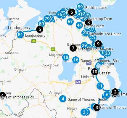
Download PDF Map of Game of Thrones Ireland Sites AND Ireland Attractions Map, Click HERE
Click on the map pins on the interactive or pdf map above for additional information including images and videos of the specific Game of Thrones Ireland Film Location or general Ireland attraction information
Know the difference between Northern Ireland and Republic of Ireland
Ireland is politically divided into Northern Ireland and the Republic of Ireland (Southern Ireland). The Tour and Map below will allow you to go seamlessly across the soft border as there is no passport control or border patrols between Northern and Southern Ireland. Geographically both regions are similar; you will know when you have crossed the border because Northern Ireland is a part of the United Kingdom and they use British Pounds as currency and road distances are in miles (imperial system). Republic of Ireland is part of the European Union (EU) therefore the currency is in Euros and signposts are in kilometers (metric system).
Travel Guide for your Northern Ireland Road Trip
Start of Self Guided Game of Thrones Ireland Tour
(items 1 –82 plus 10 Game of Thrones Doors plus other attractions along the coastal route)
1. Mourne Mountains (Click on the Mourne Mountain map pin on Game of Thrones Ireland Map to see scene images)
The Mourne were Mountains formed over 50 million years ago and shaped over the millennia by volcanic activity and the advance and retreat of glaciers. The mountain range spans over 370sqkm with a varied landscape, 100km north of Dublin and 50km south of Belfast. Things to do include visiting the Game of Thrones site, walking the trails in the area or exploring the Mourne Wall. The area has been designated as an Area of Outstanding Natural Beauty (AONB) with its mountain peaks, rolling hills, rocky cliffs, grassy plains and sandy beaches. Areas to explore include:
- High Mountain ranges of 12 rounded peaks comprising of granite. They are an extraordinary mountain range with some of the highest peaks in Northern Ireland
- The Mourne Plain includes the lower slopes of the range that fan out to the sea and are identified by the patchwork of lush green fields, dotted with granite boulders left from the retreating glaciers
- The Drumlins are characterized by an undulating field of mounds following the curve of the mountains. The mounds look like a “basket of eggs” from a distance and are the result of debris carved out by the ice sheet from Lough Neagh
- The Mourne Coast with its diverse landscape of sandy beaches, rocky cliffs, sand dunes and large boulders
The Mourne Wall
One of the most striking features is the Mourne Wall, a stone border 35km long, 8 feet high and 3 feet wide. The border follows the landscape traversing 15 rolling hills designed to keep animals away from the Silent Valley reservoir. The Mourne Wall was completed in 1922 after 18 years of construction.
Game of Thrones Film Location in Ireland: Mourne Mountains
- Mourne Mountains are used as a backdrop in several Game of Thrones Scenes with Vaes Dothrak, the only city in the Dothraki Sea, and capital of the nomadic Dothraki people. Scenes from Mourne Mountains landscape appears:
- At The Horse Gate (Dothraki: Hrazef Emrakh ) to Vaes DothrakSeason 1. The Kaleesi (Daenerys), Ser Jorah and the Dothraki visit Vaes Dothrak
- Season 1, Episode 4. “Cripples, Bastards and Broken things” Khal Drogo’s khalasar arrives at Vaes Dokrath
- Season 3, Episode 6. “The Climb”
Game of Thrones Season 6 location for Vaes Dothrak was not filmed in the in Northern Ireland but in desert landscape of Spain. The interactive or PDF map shows you the change in landscape, click on the Mourne Mountain map pin.
Hike Ireland / Walking Tours Ireland:
- A Walkers Guide – This is a complete 23 page guide with choices of several hiking routes from 15 miles to 23 miles. The guide includes itineraries, accommodation, where to eat, and transportation options
- Shorter Walking Routes – Linear and circular routes starting at 0.5 miles. Click on the + sign next to “Walks in the Mourne Mountains” for a list of walks in the area
- The Brandy Pad Path – A 7.3 miles route that takes you on the route used by smugglers in the 18th and 19th century. They landed at Newcastle and loaded their illegally smuggled goods such as tobacco, coffee, silk, brandy and wine through the Mourne Mountains to Hilltown
2. Leitrim Lodge (Refer to images on Game of Thrones Ireland Map)
Ireland Game of Thrones Film Location
- Leitrim Lodge is located close to Hilltown at the base of Mourne Mountains in Co. Down and was used for the Lands North of Winterfell
- Season 2, Episode 7. “A Man Without Honor”, Where Bran and Rickon Stark escape with Osha’s help from Theon Greyjoy and the Ironborn who have captured Winterfell. The lands on which they travel are in the area of Leitrum Lodge and Mourne Mountains, ie: the Lands North of Winterfell. They actually back track through a stream to disguise their route and return to Winterfell to hide in the crypts
- Season 3, Episode 2. “Dark Wings, Dark Words”. After the sacking of Winterfell by Ramsy Bolton and capture of Theon Greyjoy, Rickon and Bran Stark head north towards Castle Black. They are accompanied by their direwolves Shaggydog, Summer, Osha and Hodor
- Season 3, Episode 2. “Dark Wings, Dark Words”. During the journey North, Bran has a vision and wakes up in the woods of Leitrim Lodge. Later on in the same episode the group encounters Jojen Reed and his sister, Meera Reed in the same woods
Game of Thrones Film Locations: Images and videos of relevant Game of Thrones Scenes are on the Interactive map or PDF map above, click on the map pins
Hike Ireland / Walking Tours Ireland:
- The Mourne Way – A walk through the Mountains of Mourne and its varied landscape. The entire route is 26 miles long. Section 5 of the walking route starts at the Leitrim Lodge car park. Click on the + sign next to “Route Description” for section 5 of the walking route). Walk part of the route and double back as it’s a linear walking route and not a circular walking route. On Google type Leitrim Lodge Car Park – in Co. Down (NOT down south!) as a destination.
3. Tollymore Forest (Click on the map pin to see images of this scene on Game of Thrones Ireland Map)
This is the first state park in Northern Ireland covering 1600 acres of natural beauty at the base of the Mourne Mountains, 60 km (38 miles south of Belfast. In the forest you’ll find many things to do including attractions such as the Shimna River, discovering large exotic trees, stopping at the caravan park, having a picnic in the designated areas, using the playground, and hiking following one of the four official hiking trails. The area was controlled by the Magnennis family after the Norman invasion of Ulster in 1177. On February 22, 1611 the area was surrendered to the English crown for a formal freehold. The land has stayed in the family sometimes passed on through marriage to the Hamilton family and the Jocelyn family until it was sold by Robert Jocelyn, 8th Earl of Roden, to the Ministry of Agriculture in 1930 and 1941.
Tollymore Forest Attractions:
- Gothic Gates – as you enter the park, note the gothic gates build by James Hamilton 2nd Earl of Clanbrassil also known as Viscount Limerick. The gothic gates and lodges were built in 1786
- Clanbrassil Barn – built in 1757, it looks like a church complete with a steeple, a bell, a clock and sundial. The area has been converted from a stable and storehouse to an education room with washroom facilities
- Obelisk – The commemorative granite obelisk located on a small hill is dedicated to the son of Robert Jocelyn who served in the Royal Navy
- Shimna River – It was used to power the five saw mills that were located here in the 1800s. There are 16 bridges that cross the river. The oldest one was built in 1726 and is called the Old Bridge. Other bridges include the Ivy Bridge, Foleys bridge, and Parnell bridge dedicated to Sir John Parnell. No bridge was the last stone bridge built in Tollymore Forest in 1842. Bridges build after 1842 were made of wood
- Hermitage Stone Shelter – Built in the 1770 and dedicated to Marquis of Monthermer, a close friend of James Hamilton, it is primarily used by women while the men fish close by
- Kings Grave – A large stone grave marker which dates back to 1500 BC
- White Fort Cashel – A circular stoned wall and the remains of farmhouse from 500AD. It is located between Horne and Parnell Bridge
Ireland Game of Thrones Film Location in Tollymore Forest
- Tollymore Forest Park is the location Winterfell Forests. In one of the more prominent scenes, Ned and his group find the direweolf pups. Here you see them crossing a bridge. The bridge is the Altavaddy Bridge which is at a point where the Spinkwee River flows into the Shimna River
- Season 1 Episode 1. Winter is coming” The Night’s Watch find the bodies of the Wildlings, before encountering the White Walkers. The Night Watcher named Will escapes and is later beheaded for fleeing. This scene was filmed in the summer and truckloads of fake snow transported to Tollymore forest to show the winter scene
- Season 1, Episode 1. “Winter is coming”. The Starks find the Direwolf Pups. After the execution of the Night Watch deserter Will (who warns Ned about the White Walkers), “Ned” Stark is returning to Winterfell with his sons Robb and Bran, Jon Snow and his ward Theon Greyjoy. They find a dead mother direwolf and a litter of puppies which they adopt
- Season 1, Episode 2. “The Kingsroad”. Jon and Tyrion travel from Winterfell to the Wall where they break to make camp and have a lengthy chat.
- Season 3, Episode 3. “Walk of Punishment” where Theon Greyjoy escapes the evil Ramsay Bolton, is filmed in Tollymore Forest park.
- Season 4, Episode 10. “The Children” The forest was used when Bran has a dream in which he begins to chase the three-eyed raven
Hike Ireland / Walking Tours Ireland:
To visit all these filming locations will require a round trip walk of around 2 miles in the forest park from the car park. You can see a map of the trails in Tollymore Forest park HERE.
- a copy of the PDF map click HERE
- Arborteum Trail – Planting in the Arboretum began in 1752 and it is one of the oldest arboreta in Ireland. The half mile long circular route is designated by blue markers
- River Trail – is approximately 3 miles long with a park along the river to the Parnell Bridge; it is marked by red markers. Along the way you will find rocky outcrops, the grottoes, caves and bridges
- Tollymore National Outdoor Center – State of the art center; activities include, canoeing, rock climbing, and mountaineering. It is managed and funded by Sport Northern Ireland
4. Gosford Castle (Refer to scene images on Game of Thrones Ireland Map)
The castle was constructed by the 2nd Earl of Gosford, Archibald Acheson, in the mid-1800s and is said to be Northern Ireland’s largest castle.
It was in the Norman Revival designed by London architect Thomas Hopper. The Earls of Gosford occupied the castle until 1921 when it was sold. During the Second World War, the Castle was repurposed used as a prisoner of war camp and to accommodate troops.
After the war, the estate was sold to the Ministry of Agriculture by the Achesons. The Ministry established the 590-acre demesne as Gosford Forest Park and in 1986, this was designated as Northern Ireland’s first conservation forest .
Unfortunately, during “The Troubles” the castle once again was repurposed for military use. In 1983 it was run as a hotel. In 2006 the Gosford Castle Development Limited purchased it and proposed a £4m budget to convert it into 23 luxury residences. The project has been stalled since 2010 due to financial issues.
Things to do in the area are exploring the castle by following one of the designated walking trails or visiting the Game of Thrones sites.
Game of Thrones Film Location in Ireland, Gosford Castle
- Gosford Castle and its land is used as exterior scenes of Riverrun Castle, home of House Tully
- Season 3, Episode 5. “Kissed by Fire” Rickard Karstark and several of his followers murder Martin and Willem in their cell to avenge the deaths of his sons. For murdering two unarmed prisoners, the orders are that Rickard’s men be hung and that Lord Karstark himself be beheaded. The execution takes place outside the grounds of Riverrun ie: the gardens of Gosford Castle
- Season 6, Episode 7. “The Broken Man”. The siege at Riverrun by Ser Brynden Tully, who has retaken his ancestral home. Lothar Frey and Walder Rivers try to convince Blackfish into surrendering the castle by threatening to hang his nephew Edmure. Blackfish refuses to surrender, and the Freys take Edmure down from the gallows
- Season 6, Episode 8. “No One”. Brienne and Podrick arrive at Riverrun to broker a peaceful resolution to the siege between Blackfish and the Lannister who have brought an army
Hike Ireland / Walking Tours Ireland:
- Gosford, Arboretum Trail – A circular route for 1.1 miles from the Gosford Forest car park through the Arboretum and walled garden
- Park Boundary Trail, Gosford – From the car park, this is a 3.4 miles circular route deep into the forest
- Gosford Park Castle Trail – A 1.8 mile circular route from the car park to the Arboretum, walled garden, woods and the boundary of the privately owned, not accessible Gosford Castle
- Red Deer Trail, Gosford park – A short 1.2 mile circular route to the Red Deer Herd
- The Gosford car park has a children’s playground close by and has toilet facilities
5. Inch Abbey (Refer to the Game of Thrones Ireland Map that has images of this scene)
This was a gothic monastic settlement dating back to 800AD; it is a pre- Norman monastic settlement. The site was built along the marshes along the North bank of the River Quoile. It was built on a site between two drumlins northwest of Downpatrick. A drumlin is a rolling hill formed by a glacier and looks like an inverted spoon. It was plundered and raided over decades by the Vikings. Inch Abbey was built on this site by John de Courcey in 1178 AD establishing a Cistercian abbey.
Once completed, it was occupied by the monks from Furness Abbey in England. It included a cloister, transept, north tower, prayer house, vestry, chapels, kitchen, bakehouse, a well, a detached guesthouse. The abbey was dissolved in 1541. All that remains are foundational walls and an impressive east wall. Things to do in the area include reenacting the Game of Thrones scene in full Game of Thrones gear as many have done for their Instagram feed or simply follow the walking paths and explore the area.
Ireland Game of Thrones Film Location for the Stark Camp
- Stark Camp, Riverrun, Riverlands. The monastic ruins on the River Quoile were famously the location where Rob Stark’s Bannermen named him King of the North
- Season 1, Episode 10: “Fire and Blood”. Catelyn informs her son Robb Stark that his father has been executed, by King Joffrey Baratheon. Robb is later declared King in the North
6. Quoile River (Refer to images of Trident River, the associated scene on Game of Thrones Ireland Map)
Just near Inch Abbey is the Quoile River, a waterway running through a large area of wetland where you’ll find plentiful wildlife viewing and walking opportunities. The wooden jetty for the Quoile River is a Game of Thrones film location.
Game of Thrones Film Location at Ireland Inch Abby
- Used
as scenes of Riverrun. Quoile River is Trident River in Game of Thrones, the
location of Hoster Tully’s funeral
- Season 3, Episode 3. “Walk of Punishment”. Hoster Tully’s funeral is being attended by Robb and Catelyn Stark, Edmure and Brynden Tully who are standing on the jetty. As his funeral boat float down the river, the boat is set on fire with a flaming arrow by Brynden Tully
7. Castle Ward ((Actual scene images are on Game of Thrones Ireland Map)
Located on the shores Strangford Lough in County Down, the castle is a mixture of gothic and classic styles representing the tastes of Lord Bangor and his wife Lady Ann Bligh. The entrance side is classical architecture while the other side is gothic with pointed windows and funerals. You will find this dual nature in the interior as well.
With 820 acres, it has a landscaped garden, a working corn mill, a sawmill, a Victorian laundry, tower, and modern additions to the existing building that includes a restaurant and theatre.
The Earl of Kildare originally owned the castle; he sold it to Bernard Ward, 1st Viscount Bangor, in the late 1500s. The Ward family owned the property until it was given to the Government of Northern Ireland in lieu of death duties after the death of the 6th Viscount in 1950. A National Trust was established in 1952 that included the land and buildings.
A tragedy struck the castle when in 1973 two young people, both were members of the IRA; 23 year old Leonard O’Hanlon and 17 year old Vivienne Fitzsimmons were killed when a bomb exploded accidentally.
There are a variety of things to do at Castle Ward. You can spend the whole day at the castle as there are both hiking and biking trails. Enjoy browsing through the second hand book store or enjoying scones and tea at the restaurant. There are activities for kids including children’s crafts, a farmyard with farm animals, a playroom or activities such as riding the tractor; you can also visit the artist studios to see them at work. Check their website for visiting hours, entrance fees and activities.
Castle Ward is the next Ireland Game of Thrones Film Location
Castle Ward is the site of Winterfell Castle
- Winterfell Castle from Season 1 (CGI – Computer enhanced). Numerous scenes from multiple episodes From Season 1 of the show were filmed at Castle Ward,
- Season 1:
- The archery training scenes with Bran (Episode 1″Winter Is Coming”)
- The door where Tyrion and Jon first meet (Episode 1)
- King Robert Baratheon and his family visit to Winterfell to name Ned Stark the Hand of the King, after Jon Arryn died (Episode 1)
- Bran is pushed from the tower window by Jaime to keep the incest with Cersei a secret (Episode 1)
- The smithy where Arya’s sword “Needle” is forged (Episode 2 “Kings Road”)
- Tyrion designs a saddle for the paralyzed Bran (Episode 4 “Cripples, Bastards, and Broken Things”)
- Bran and Rickon are informed of Ned’s execution (Episode 10 “Fire and Blood”)
- Season 2:
- Theon takes Winterfell and Bran, Rickon and Osha escape (Episode 6 “The Old Gods and the New”
- Two charred bodies presented by Theon identified as Bran and Rickon (Episode 7 “A Man Without Honor”)
- Theon refused to leave Winterfell with his sister Yara (Episode 8 “The Prince of Winterfell” )
- Season 2 Episode 10. “Valar Morghulis”. The sacking of Winterfell by the Boltons. Bran and Rickon escape and head north to Black Castle and Jon Snow
- If you see an exterior of Winterfell in season one, it’s Castle Ward (with a bit of CGI clamped on).
- Season 1:
8. Game of Thrones – The Old Tower at Winterfell (Refer to images on Game of Thrones Ireland Map)
- In season 1, episode 1; This is the scene where Bran is pushed from the tower window by Jaime to keep the incest a secret. He survives and is in a coma. He was pushed because he accidentally witnessed the incestuous relationship between Queen Cersei and her brother Jaime.
9. Audley’s Field & Castle (Images of the actual scene is on Game of Thrones Ireland Map)
The castle located on the shores of Strangford Lough, is named after the Anglo-Norman family, the Audley’s, who owned the castle and the land around it from the 12th to the 16th century. It is not known if they built the castle, however the three story tower castle was sold in the 16th century to the Ward family and lies on the grounds of Castle Ward estate. Outside the castle was the village of Audleystown, where all the villagers were evicted and shipped to America by the Wards in the 1850’s. During the 18th century the area around Audley castle was converted into a landscape park with an artificial lake, referred to as Audley’s Field.
Audley’s Castle Ireland Game of Thrones Film Location is a number of episodes
- Audley’s Castle, referred to as “The Twins”, home of the Freys and is in Riverlands. In the Game of Throne scenes, there are two castles, an additional castle was cgi enhanced into the film shots. There was a toll for those wishing to cross the towers. The grassy knolls around Audley’s Castle were used as a location for Robb Stark’s camp, the Lannister army camp, and generic location for general shots of army camps. The Twins appear in a number of episodes, including
- Season 1, Episode 2. In nearby Strangford Lough (Lough=lake), Sansa’s direwolf “Lady” is executed in
- Season 1 Episode 8. “The Pointy End” Tyrion and Bronn into the Vale and towards Tywin Lannister’s camp.
- Season 1 Episode 8. “The Pointy End” Rodrik Cassel and Catlyn Stark travel to meet Robb’s army
- Season 1, Episode 9. “Baelor”, where Theon shoots down the messenger ravens leaving the castle
- Season 2, Episode 1. “The North Remembers”
- Season 2, Episode 4. “Garden of Bones”. ” This was where the Battle of Oxcross takes where Rob Stark meets his future wife Talisa, and breaks the marriage pact with the Freys leading to the Stark family massacre by the Freys at the Red Wedding
- Season 2, Episode 6. Catyln Starks warning to her son Robb of the consequences of breaking his marriage oath with the Freys
- Season 2, Episode 7. “A Man Without Honor”. Robb Stark’s camp where Jamie and Alton Lannister are held prisoners and Jamie kills Alton
- Season 2, Episode 10. “Valar Morghulis” Brienne of Tarth escorts the captured Jamie Lannister to the safety of Kings Landing. Along the path they encounter three bodies hanging from a tree. After which they come upon three Stark guards responsible for the hanging. Brienne kills them
- Season 2, Episode 10. The secret wedding of Robb and Talisa
10. Quintin Castle (Refer to images on Game of Thrones Ireland Map)
Across Strangford Lough on the Ards Peninsula is Quintin Castle. The castle is east of the village of Portaferry on the Irish Sea and was built by Knight, John de Courcy in 1184. The next owners were the Savage family after which their dependents, the Smiths occupied the castle until the 17th century. It was then purchased by Sir James Montgomery also of the Smith family. Since then the castle has been sold several times and is now a private residence and not accessible to the general public. There are many things to do in Portaferry and a list is available at the visitors center. To get to the castle, catch the ferry from Strangford to Portaferry, which takes 15 minutes and costs £5.50 depending on the size of your car. Then drive to Quintin Bay along the eastern coastline.
Ireland Game of Thrones Film Location at Quintin Bay
- Quintin Bay and Castle were used for the setting of Stokeworth Castle
- Season 5 Episode 2. “The House of Black and White”. Standing outside Stokeworth Castle Jamie convinces Bronn to accompany him to Dorne and bring Marcella back to Kings Landing. The landscape in the scene is original however Quintin Castle was edited out and replaced with a much grander façade using CGI. The castle itself is a private residence and is not open to visitors
11. Rowallane Garden (Refer to images on Game of Thrones Ireland Map)
The 50 acres garden was laid out from the mid-1860s by the Reverend John Moore. He built a walled garden, created the Pleasure Grounds and planted many trees. In 1903 the garden passed to his nephew, Hugh Armytage Moore, who further expanded the gardens by establish international connections. This resulted in plants and trees from China, Tibet, South and North America, New Zealand, and Japan. Some things to do at Rowallane Gardens include watching the artisan potters at work, taking a peaceful walk around the gardens or browse the garden shop for seeds for your garden.
Ireland Game of Thrones Film Locations for Goswood
- Rowallane Garden is the location of Godswood. Godswood are places of mediation, worship and reflection enclosed within castle walls. These wooded sanctuaries dedicated to the Old Gods of the Forest and centered around a weirwood tree with a face carved into the trunk
- Season 1, Episode 1. Ned and Catelyn talk at Godswood where she tells him that John Arryn is dead from a fever and that the King and his family are coming to Winterfell
- Season 1 Episode 7. Oath of Jon Snow, Samwell Tarly and the night watchmen in front of a Weirwood Grove just north of Castle Black
- Season 6 Episode 5. A vision with Godswood in it where Bran learns who created the White Walkers
Season 7, Episode 3. Bran and Sansa at Godswood where he tells her he is the three eyed raven - Season 8, Episode 4. Jon Snow tells Sansa and Arya his true parentage in Godswood
Hike Ireland / Walking Tours Ireland:
- Rowallane Garden Walk – Walk for up to 2 miles along the walled garden, the paddocks, forested woods, rocky outcrops of the garden path. Select your trail and start at the visitor parking lot
12. Belfast
Belfast has been inhabited since the Bronze Age where the megalithic tomb, Giants Ring is close by. The surrounding hills of Belfast are home to a number of Iron Age Hill Forts and Castles. Belfast became a sizable settlement in the 17th century and was granted City status in 1888 by Queen Victoria. Today it is capital of Northern Ireland, and the launching place of the RMS Titanic, which was tragically struck by an iceberg and sunk in 1912 with a loss of 1400 lives.
Belfast was a hotspot during “The Troubles” and both the people and the city suffered greatly. In the 1970’s and 1980’ it was one of the most dangerous cities with a death rate of 31 per 100,000 per year.
Belfast has tried to move past “The Troubles” and has undergone substantive expansion and growth including the large £500 million project called “Tribeca” in the city center. Today Belfast is a thriving city with a major port and two airports, boosted by tourism in Northern Ireland and recognition in the Game of Thrones Series.
Ireland Game of Thrones Door 10
Door 10 is located in the Cathedral district of Belfast. Scenes from Episode 10 “The Winds of Winter” are carved into the door. The Lannister Lion dominates, with scene from the Sept of Baelor, the deaths of kings landing nobleman. The base is the sigils from both the House of Stark and House of Targayen, alluding the true lineage of Jon Snow.
Six stained glass windows in Belfast show prominent scenes from Game of Thrones. Following the 1.8 miles stained glass self guided tour will take you from city hall to the titanic studios. Click on the Map HERE.
Belfast Game of Thrones Ireland Window Panes Tour:
- City Hall, Belfast – The first window depicts scenes from the House of Stark including Ned’s execution, the Red Wedding and the battle of the Bastards
- Convention Center, Belfast (ICC Belfast) – This window represents moments from the Lannister House. Dominating the window is Cersie being carried by The Mountain. You will also note scenes of the destruction of the Sept of Baleor and the death of Prince Oberyn Martell
- Lagan Weir – The Baratheon Window showing scenes from Melisandres, the Red Woman. It shows the death of King Robert, King Joffery and the Stannis’ burning fleet in the Battle of Blackwater
- The Odyssey Complex – Location of the 4th stained glass window representing House Targaryen. Daenerys and her dragons take a prominent position. Scenes from the Battle of Goldroad, Viserys “golden crown” and The Sons of the Harpy are also featured
- Titanic Belfast – Window 5 features the White Walkers and the Knight King. Glowing eyes, raising the dead and Hardhome are all featured in the pane
- Titanic Slipways – The last and final window depicts scenes related to the much coveted Iron Throne, ruler of the Seven Kingdoms. Featured are symbols representing the prominent families: direwolves representing House of Stark, Dragons representing House Tagaryen, the Tyrells rose, House Lannisters lions, House Tully’s trout and the Martells spear
13. Titanic Studios (Interior sets for Game of Thrones Film Scenes)
The Game of Thrones production has moved a lot of the filming directly in Belfast, and they are recreating a massive set in the Titanic Studio.
14. King William III Monument (Refer to images on the Ireland Attractions Map)
Overlooking the harbor is a life size bronze statue of the King commemorating his arrival at Carrickfergus harbour in 1690.
15. Carrickfergus Castle (Refer to images on the Ireland Attractions Map)
The castle is located north of Belfast and is older than the city of Belfast. In 530 AD the King of Scotland, King Fergus, heard of a tear shaped rock or crag that stuck out of the sea that had a holy well that could cure his skin disease. He set out to find it and during a storm his ship crashed against the very rock he was searching for, killing all those on board. The Carrickfergus castle was built by John de Courcy in the late 110’s on the very rock where King Fegus ship was wrecked.
The castle was surrounded on three sides by water. Today the water is only on one side of the castle. De Cousy started with a massive “keep”. A keep is an inner fortified tower that would be similar to today’s panic room, and was the inner fortification within a castle. Inside the keep is a fresh water well at its center. The keep was 50 meters high with a 4 meter thick wall. The ground was a storage house for food and water, the ground floor had a small window and was the guardhouse, the second floor the office, where the lord of the manner held court, the next floor were the private apartments and the battlements were at the top were sentries kept a lookout.
The second stage of the castle, the middle section, was built in 1215 with servant and soldiers quarters. The outer section was built in 1230 including a gatehouse and a moat and drawbridge on the land side. The outer walls included a wall walk allowing soldiers to access all parts of the castle from the top of the walls. This completed the castle with water on three sides and a drawbridge on the land side. Outside the castle a small town grew and both the Carrickfergus castle and Carrickfergus village prospered.
Carrickfergus History
For the next 600 years the castle came under attack without success on many occasions by the English, the Scots, and the French. Carrickfergus was strategically placed and conquering Ireland meant controlling Carrickfergus.
Over the decades, Carrickfergus castle has been used to house prisoners of war, a magazine and armoury, and army storage, housing a garrison. During WW1 anti-submarine guns were mounted here protecting Belfast Lough, and in WWII it was used an air raid shelter. After surviving 800 years of continuous military occupation, the castle was transferred to the Northern Ireland Environment Agency in 1928 and preserved as a historic building.
Carrickfergus is the most well preserved medieval structure in Ireland. You can easily spend a 1/2 day by touring the castle then stroll the sea promenade complete with benches and a picnic area. There are many things to do in Carrickfergus town including walking from the Castle to the town of Carrickfergus. It is a great place to explore and stop by for some lunch, high tea or a pint at one of the local pubs.
16. Shanes Castle (Refer to images on Game of Thrones Ireland Map)
Shane’s Castle, originally referred to as Eden-duff-carrick, was built in 1345 by a member of the McNeill clan. In 1722 it passed onto Shane MacBrien O’Neill, who changed its name to Shane’s Castle. According to legend, a banshee started a fire in anger over her usual empty room being occupied. This now ruined castle located on the north shore of Lough Neagh is part of a working estate that includes farmland, woodland, cattle and sheep. It is not open to the public.
Ireland Game of Thrones Film Location at Shanes Castle
- Shane’s Castle was used in several scenes including as The Land of Always Winter and The Wildlings Site. It has also been used in scenes for the crypts of Winterfell and the dungeons of Kings Landing.
- Season 1, Episode 4 “Cripples, Bastards and Broken Things” Location of the Tourney of the Hand in King’s Landing to celebrate the naming of Ned Stark as Hand of the King to Robert Baratheon.
- In Season 1, and episode 5 “The Wolf and the Lion” Fight between the two brothers: The Hound and The Mountain where Gregor beheads a horse
- Season 3, Episode 2 “Dark Wings, Dark Words” The nearby bridge meanwhile, was the setting for the sword fight between Brienne of Tarth and the Kingslayer (Jamie Lannister)
- Interior shots of Shanes’ castle were used with Cersei in the cellars at Kings Landing, scenes with the Faith Militant and crypts of Winterfell
17. Toome Canal (Refer to images on Game of Thrones Ireland Map)
Toome is a small village with a population of about 781 as per the 2011 Census located in the north west corner of Lough Neagh. It was made famous as a film location site for the Game of Thrones. There is a 2 km walk along Toome Canal to the shores Lough Neagh and a 10 min walk to Toome Village.
Ireland Game of Thrones Film Location at Toome Canal
- Toome Canal was the scene of Old Valyrian Canal, Essos
- Season 3. In the later episodes of season 3, Jon, Ygritte and Tormunds wilding band cross to the south side of the wall in the wooded area around Toome Canal
- Season 5, Episode 5. “Kill the Boy”. Jorah takes a shortcut through Valyria
- Season 5 Episode 4. “Sons of the Harpy” Jorah captures Tyrion and steals a boat to take his captive Tyrion to deliver him to his Queen Daenerys in Meereen in the hope of getting back into her favor. He sails through Toome’s Canal
- Season 5, Episode 5. “Kill the Boy”. Jorah sets off with Tyrion down the Old Valyrian
Hike Ireland / Walking Tours Ireland:
- Toome Canal Walk – a 1.2 mile walk along the canal towards the shores of Lough Neagh
18. Lough Neagh (Refer to images on Game of Thrones Ireland Map)
Pronounced LOKH NAY, it is the largest freshwater lake in the UK suppling Northern Ireland with 40% of its water supply. The lake was a depression that was filled in by melting of glaciers during the last ice age. It touches the borders of five of the six counties of Northern Ireland and eight rivers flow into it, however only one river flows out, the River Bann. The fishing rights have been disputed over the centuries and today the Lough Neagh Fishermen’s Co-Operative maintains the sustainability of the fishing industry in the Lake. The area is famous for the local fish called “Pollan, a fresh water herring. The Pollan has been recognized by the European Union Protected Geographical Indication Scheme. The lake has unusual petrification ability; recently a petrified 10,500 year old Irish elk skull measuring 3.6 feet across was caught in a fisherman’s net. Also, centuries old branches has also been preserved and discovered in the lake. There are many things to do in Lough Neagh including visiting the Ballyronan marina, the Craigavon Watersports center or attending some of the summer events at Lough Shore Park.
Ireland Game of Thrones Film Location at Lough Neagh
- Lough Neagh was transformed into the location for Summer Sea located south of Essos and Westeros
- Season 5, Episode 5. “Kill the Boy”. Jorah and his captive Tyrion travel from the Old Valyrian Canal (Toome Canal) to Summer Sea (Lough Neagh) on their way to Meereen. They see Drogon and are attacked by stone men. Jorah saves Tyrion from drowning and in the process becomes infected with greyscale. After being attacked they land and hide on shore (Game of Thrones location for the Bay is Murlough Bay, Northern Ireland. As they walk towards Meereen, they are captured by Slavers along the way
19. Magheramorne Quarry (Refer to images on Game of Thrones Ireland Map)
Margheramorne is a small village of about 77 inhabitants with an old stone quarry that closed in 1980. There have been several proposals to convert the area into a Premiere Cycling Center or a Scuba Diving Center. The quarry was used as a Game of Thrones location and the sets were built onsite and dismantled after use. As such there is nothing much to see in the abandoned quarry.
GPS Coordinates:
- 54.810833333333. -5.76
- 54° 48′ 39” North , 5° 45′ 54” West
Ireland Game of Thrones Film Location The Quarry
- The Quarry appeared as the location of Castle Black (Headquarters of the Night Watchers), Hardhome and “The Wall”
- Season 4, Episode 9. “The Watchers on the Wall” The battle between the Nightwatch and the Wildings
- Season 5, Episode 8. “Hardhome”, White Walkers attack the village of Hardhome while Jon Snow and his party are present. The Night King revives the dead as wights (undead). Jon and his party escape. The battle takes a month to film at Magheramorne
- Season 5, Episode 9. “The Dance of Dragons”. Jon Snow and the Wildings return to Castle Black
- Season 5, Episode 10. “Mother’s Mercy”. Jon is stabbed by the residents of Castle Black and dies before being brought back to life
- Season 6, Episode 5. “The Door”. The quarry was used for outdoor snowy scenes of the White Walkers
- Season 7, Episode 6. “Beyond The Wall” The Knight King breaches The Wall and destroys Castle Black using Daenerys resurrected dragon Viserion
- Season 8, Episode 1&2. The exterior snowy scenes of Winterfell were filmed at Magheramorne Quarry
20. Gobbins Cliff Path (Refer to images on the Ireland Attractions Map)
A 2.5 hour guided walking tour along narrow paths, bridges and rugged staircases. Walk over hidden tunnels, experience nature, taste the sea salt as the waves crash against the cliffs and lookout for sea birds and dolphins. Ability to climb steps and walk steep gradients is essential. The Gobbins Cliff Path walk is a guided tour, and this popular path gets booked up quickly. It is advisable to pre-book your walk and dress for the weather.
Antrim Coastal Route
This Ireland travel guide includes one of the most scenic drives in Northern Ireland is the Antrim Coastal route from Belfast to Ballycastle. After Ballycastle the shoreline road is referred to as the Causeway Coastal Rote and extends from Ballycastle to Londonderry. To build the Antrim Coastal Route, 23,000 cubic meters of rock were blasted between 1832 and 1842 to create a narrow road between the cliffs and the Irish Sea. Built by the engineer William Bald, the purpose was to replace the Old Irish Highway. It was originally called the Grand Military Way as it was intended to be a route for the army.
Experience the scenic Antrim Coastal route with its rugged cliffs, sandy beaches and spectacular sea views. Once you reach the coastal town of Larne, the Antrim Coastal Route will take you to along the east Coast including The Glens of Antrim and the Gobbins Cliff Walk. Parts of the route was used in the 1845 Famine for migrants fleeing the valleys.
Glens of Antrim
Ireland’s landscape is varied and truly beautiful. Carved by glaciers, volcanic activity, unrelenting winds and storms, the true beauty can only be experienced up close. The Glens of Antrim (from Larne to Ballycastle) are designated as an Area of Natural Beauty (AONB), as such I have included walks, and hikes along the Glens of Antrim and all along the coastline. The Ireland Walks and Hikes are in the area of the attractions in the article and where possible the links will take you to the car parks and starting point of the hikes. The hikes are anywhere from 0.5 to 5 miles. These attraction sites will allow you to visit the Game of Thrones film locations up close and give you an opportunity to walk the dazzling waterfalls, rolling hills, rocky cliffs, the coastline, forested woods and grasslands of Ireland.
The Glens of Antrum has nine Glens(valleys) called Glenarm, Glencloy, Glenariff, Glenballyeamon, Glenaan, Glencorp, Glendun, Glenshesk and Glentaisie. The Glens/valleys were carved out by glaciers over 60 million years ago along the Antrim Coastal route.
The main villages in the Glens are Ballygally, Cairncastle, Glenarm, Cushendun, Cushendall, Waterfoot, Carnlough and Ballycastle.
Officially known as an Area of Outstanding natural beauty, The Glens are a major tourist attraction. A map of The Glens can be found HERE .
A summary of the Glens and where appropriate the Game of Thrones Ireland Film Location is indicated. Please refer to the Game of Thrones Ireland Map above for directions, images and videos.
21. Larne (Refer to images on the Ireland Attractions Map)
Larne is a small harbor town undergoing rapid development. Community development activities include artistic murals, art exhibitions, cafes, and “The Goodwill Music Festival. These have made Larne a desirable place to live and work.
Edward Bruce, the brother of King Bruce 1 of Scotland, landed near Larne in 1315 to help free the Irish from English rule. Unfortunately, his death three years later ended the free Ireland movement at Larne. Today Larne is a seaside holiday resort. The deep water harbor at Larne has several cargo berths ideal for commercial import/export of goods. It can also handle cruise ships up to 180m. The port handles over 200,000 freights per year and 550,000 passengers. Unsurprisingly Larne’s main industry is harbor services and tourism.
Things to do in Larne include a walk in Carnfunnock Country Park, visiting attractions such as Olderfleet Castle, Larne Museum and Arts Centre, the Chaine Memorial Tower or take the 2 hour ferry from Larne to Cairnryan, a small village in Scotland.
22. Carnfunnock (Refer to images on the Ireland Attractions Map)
Carnfunnock’s location is ideal for exploring the stunning Antrim Coast, The Glens of Antrim and the rest of Northern Ireland. The 191 hectares Carnfunnock Country Park is a wonderful blend of gardens, woodland and coastline. The Maze and Walled Gardens are open all year round and things to do in the area including a golf driving range, outdoor playground, waymarked walking trails, picnic area and public toilets. Their annual programming includes events such as snake handling, bug hunting, pond dipping, and seeing wildlife such as foxes, and hedgehogs up close.
Hike Ireland / Walking Tours Ireland:
- Carnfunnock Walks – (Number 22 on interactive or PDF map). Four walks from 0.8 to 2.5 miles in Carnfunnock, including the Woodland Walk, the Shore Walk, the Heritage Walk, the Garden Walk and the Biodiversity Walk
23. Ballygally Castle (Refer to images on the Ireland Attractions Map)
One of my favorite places to stop in Northern Ireland travel guide. We stopped here for a lovely lunch here in the hotel. James Shaw built he castle in 1625 and his descendants sold it in the 1799 to entrepreneur Cyril Lord. It was sold again in the 1950’s to the current owner, the Hastings Hotel group. At that time the property underwent extensive renovations including expansion of the castle. Ballygally Castle is known to be the most haunted castle in Ulster and the only 17th century building used as a residence in Northern Ireland.
It is the haunting of Lady Isobel Shaw. She was locked in her room by her husband James for failing to provide a male heir. In her attempt to flee with her baby girl, she either fell or was pushed from the tower window about 400 years ago. Book the Ghost room at the castle if you are brave enough. A word of caution, there is more than one ghost that has been sighted and psychic mediums have been reported to say that there are more ghosts then guests at the hotel!
Things to do include visiting the village that is nestled at the foot of lush green hills, spending the day at the sandy beach, fishing, sailing or walking the trails around Ballygally.
History Behind The Game of Thrones Doors
During Storm Gertrude in 2016, some trees from the Game of Thrones famous Kings road, known as Dark Hedges, fell. This coincided with the release of Game of Thrones Season 6. To preserve the “memory” of the trees, 10 doors were intricately carved from the fallen trees. Each door representing one episode of season 6. These 10 doors are hung throughout Ireland. Door #9, representing Episode 9, is hung at Ballygally Castle so make sure to visit it if you are there.
Ireland Game of Thrones Door 9
- Ballygally
Castle is on the Causeway Coastal route and is the home of one Game of Thrones
Door No 9. Episode 9: Battle of the
Bastards
- Carved into the door are the crests for the House of Stark and the House Bolton. You will also find the direwolves at the base of the door flanking a tortured man, perhaps foretelling a House of Stark victory; central to the door is Winterfell, the Starks ancestral home
24. Cairncastle (Refer to images on Game of Thrones Ireland Map)
A small village with a population of under 100 is the start of the Glens of Antrim. The village church was founded in 1646 and is one of the oldest presbyteries in Ireland with Carrickfergus being the oldest. The landscape adjacent to Carincastle was used for several Game of Thrones Film Locations. This has raised the profile of this village and increased the number of tourists who visit.
Ireland Game of Thrones Film Location at Cairncastle
- Cairncastle was used in several Game of Thrones Ireland locations for scenes related to Winterfell, Harrenhal, Riverlands and Moat Caillin (the Neck)
- Season1, Episode 1. “Winter is Coming”. At the start of Games of Thrones series, the Mountains above Cairncastle were featured in the scene where Ned Stark executes Will, a Night Watchman. He believed Will was a deserter
- Season 3, Episode 7. “The Bear and the Maiden Fair”. This was the resting stop of Jaime Lannister and Qyburn, after Jamie was released. They were on their way back to Kings Landing. At the rest stop, Qyburn tends to the stump of his lost hand
- Season 5, Episode 3. “High Sparrow”. The location of Moat Cailin, where Sansa is coerced by Littlefinger (Lord Baelish) and agrees to marry Ramsay Bolton. The basalt outcrop is meant to represent The Neck
- Season 6, Episode 7. “The Broken Man”. Sallagh Braes is Riverlands the home of the Hound (Sandor Clegane) who has turned his back on his violent past. He now lives a peaceful existence in a small village until the men from the Brotherhood without Banners, murder the villagers
25. Linford Car Park
Located on the Ireland map, this is the entry point for many of the walks and Game of Thrones Film Locations in the area.
- 26. Sallagh Braes is west Cairncastle and Knock Dhu (mountain). It is a hill with an elevation of 352 meters and Knock Dhu is a basalt mountain escarpment (an actual Bronze Age promontory fort). Both Knock Dhu and the fort are on the northern edge of the Sallagh Brae. Refer to map above for location.
27. Sallagh Braes (Refer to images on Game of Thrones Ireland Map)
Sallagh Braes is a hill in the Glens of Antrim just behind the village of Cairnastle. It is west of Knockdhu, a basalt escarpment in the area and the location of several Game of Thrones scences. Game of Thrones has raised the profile of Cairncastle and the landscape around it. At the top of the Sallagh Braes is Knockdhu, the site of a Bronze Age fortress. Sallagh is a designated an Area of Outstanding Natural Beauty (AONB).
Ireland Game of Thrones Film Location at Sallagh Braes
- Sallagh Braes is the location of Riverlands
- Season 6, Episode 7. “The Broken Man”.The location of Riverlands, the home of the Hound, Sandor Clegane, who lives in a quiet village in Riverlands. He has denounced his violent past and lives peacefully until the Brotherhood without Banners kills the villagers forcing the Hound to exact revenge
Hike Ireland / Walking Tours Ireland:
- Sallagh Braes Walk / Additional Info– Starting at Linford Car Park this is a 1.8 mile walk (the car park is an interactive or PDF Game of Thrones Ireland map above). Walk along the exposed hillside, neolithic burial sites towards the edge of the Sallagh Braes basalt cliffs. Caution is urged along the Cliffside.
Check the terrain, wear walking or hiking shoes, bring water and be prepared for bad weather. Walks in Northern Ireland have spectacular scenery and are well worth the effort however, caution is advised as the weather can change very quickly.
28. Shillanavogy Valley (Refer to images on Game of Thrones Ireland Map)
The picturesque Shillanavogy Valley lies at the base of Slemish Mountain in the Glens of Antrim
Ireland Game of Thrones Film Location at Shillanavogy Valley
- Shillanavogy Valley was the site of the Dothraki grasslands in Essos located in the Dothraki Sea, East of Pentos
- Season 1, Episode 1. “Winter is Coming” Daenerys and Drogo’s marriage was filmed at the base of the Slemish Mountain in the Shillanavogy Valley,
- Season 1, Episode 2. “The Kingsroad” Daenerys, Viserys and the Dothraki camp in the fields that later become their Dothraki home. This is also the scene where Daenerys Targaryen and the Dothraki as they travel to Vaes Dothrak
Click on the map pins on the interactive or pdf map above for additional information including images and videos of the specific Glens of Antrim Game of Thrones Scene
29. Sleamish Mountain (Refer to images on Game of Thrones Ireland Map)
Slemish Mountain is actually the plug of an extinct volcano rising about 1500 feet (437 metres) above the surrounding plain. It is also the Irish home of St. Patrick. He was brought here as a slave by pirates after they killed his family. He was a Shepard for the local Chieftain, Milchu, from the age of 16 to 22.
It was during this time that Patrick communed with nature. It is said that it was on the mountain he sought peace and solitude and turned to prayer. His conversion to Christianity is believed to have taken place on Slemish Mountain. In one of his visions, he was encouraged to escape and return home. He left Ireland, became a priest and returned to Ireland to convert the people to Christianity.
While not the first Bishop to Ireland, his ministry centered in the North where St Patrick established churches and an episcopal system.
Hike Ireland / Walking Tours Ireland:
- Slemish Walk – A short linear walk of 1.2 miles from the Slemish car park, some of the terrain is step and rocky
- Sleamish Mountain Hike – Hike to the summit and back. The hike is approximately 1.5 km to the summit and back and is steep in some locations. Locals hike to the summit on a pilgrimage on March 17, St Patrick’s day
Ireland Game of Thrones Film Location at the Slemish Mountains
- Vaes Dokrath, the only city in the Dothraki Sea, Essos.
- Season 1, Several Episodes. The Slemish Mountain valley is the Game of Thrones film locatin for the ancient Dothraki city ofVaes Dothrak. Many of the scenes in Season 1 show Slemish mountain in the background of the Dokrathi Grasslands
30-31. Glenarm Village (Refer to images on Ireland Attractions Map)
Glenarm village is the home of Glenarm Castle and demesne which form the estate of the Earl of Antrim (the McDonnell Clan). The area is part of Ireland’s Glens of Antrim. The castle is the main focal point of the village. Open to the public for both a wedding venue and as a film location, onsite you will find a tea shop and gift shop. The property also has accommodation rental of its cottages including the gamekeepers cottage. Glenarm Castle was the home of the MacDonnell clan when they relocated to this area after the collapse of Dunluce Castle further north. It was the seat of the MacDonnell clan from 1750.
Hike Ireland / Walking Tours Ireland:
- Glenarm Tourism – Visit the tourism board for a list of walks in the area
- Coastal Walk, Glenarm – Walk for 1 km along the shore
- Glenarm Forest Walk – Follow the yellow markers for a half mile walk to see wildlife and views along the Glenarm river. The blue markers are for the 1 mile walk and red markers for a 2 mile walk in the area
32. Carnlough Harbour (Refer to images on Game of Thrones Ireland Map)
The local landowner Phil Gibbons built a small sheltered port on the east coast. The harbor was further expanded by the Marchioness of Londonderry to accommodate the expanding export of limestone. Visit the memorial plaque on the habour wall dedicated to “Paddy the Pigeon”. He was one of 30 pigeons that delivered coded messages across the channel during World War 2. Paddy lived for 11 years and was given the PDSA Dicken Medal, the animal equivalent of the Victorian Cross.
Things to do in Carnlough include fishing, sailing, windsurfing, hiking, walks along the marked trails exploring The Glens of Antrim or visit the Londonderry Arms Hotel, a Georgian house owned by Sir Winston Churchill at one point.
Ireland Game of Thrones Film Location at Carnlough Harbour
- Carnlough Harbour
was used as a canal in Braavos
- Season 6, Episode 7. “The Broken Man”. After being stabbed by the Waif, Arya Stark escapes by jumping into the cold water of the Braavos canal then crawling her way up the steps
Hike Ireland / Walking Tours Ireland:
- Carnlough Harbour to Cranny Falls – Walk along the old railway system from Carnlough harbour to Cranny falls. It is a a 23 min 2.4 mile walk. The falls are breathtaking and look like something out of a fairy tale. You can also drive to the falls; it is about a 6 min drive on a narrow road.
33. Glenarrif Tea House (Refer to images on the Ireland Map)
The Glenariff Tea House located at the foot of Glenariff falls is a peaceful setting to stop by for a meal or a snack. The Tea House can be rented for events such as family reunions or outdoor wedding. You can even rent accommodations on site at cottage for rent.
34. Laragh Lodge (Refer to images on the Ireland Map)
An 1880 teahouse beside the Ess-Na-Laragh (the fall of the mare) waterfall. Laragh lodge is a great place for a break or a walk around to enjoy the scenery or a place to book special events. There is a licensed restaurant serving light meals such tea and scones or full meals such as fish and chips to a steak dinner.
35. Garron Point (Refer to images on the Ireland Map)
Garron Point is a headland on the Causeway Coastal route between Carnalough and Waterfoot. There is car park at Garron Point where you can park for free. Park and enjoy a walk along the rugged coastline with stunning views of the Mull of Kintyre in Scotland and Ailsa Craig Island or simply stop by and enjoy a picnic.
36 – 37. Galboly (Refer to images on the Game of Thrones Ireland Map)
The abandoned village of Galboly in the Glens of Antrim is found above Garron Point, where there is a small car park and a Game of Thrones information panel.
The village was home to around 60 people in the mid 19th century, and had a number of stone built houses. However, over time the population declined. By 1970 there was just one inhabitant, and today the village is entirely abandoned and is slowly surrendering to the elements. As of 2019, Galboly may not be accessible.
Ireland Game of Thrones Film Location at Galboly
- Runestone, Vale of Arryn
- Season 5, episode 1 “The Wars to Come”. In this scene we see Sansa Stark and Littlefinger watching Robin Arryn who is learning how to use a sword
- Season 6, Episode 4 “Book of the Strangers”. Galboly is the location of Runestone, where a gift of a falcon is given to Robin Arryn on his nameday. Littlefinger also asks for assistance from the Knights of Vale to resucue Sansa from Ramsay
38. Waterfoot (Refer to images on the Ireland Attractions Map)
Waterfoot is a popular holiday seaside village. On the outskirts of the village you will find the “Red Arch”; the causeway coastal route passes through the Red Arch. The arch was built in 1817 by Francis Turnly to provide easy access to his estate. The headland above the Red Arch is the location of Red Bay Castle. Below the castle is a large cave that connected to the castle and provided an escape route from the castle.
The Dry Cove is another well known cave leading from Waterfoot to the Red Arch. The cave was used as the location of a “Hedge School”. Hedge schools were formed in defiance of the Penal Laws that forbade catholic schools and the teachings of Catholicism in the school system. In rural areas hedge schools were formed in secret locations to continue the practice.
There is another cove in the area called Nan (Anne) Murray’s cove. She lived free of charge in this cove from the age of 50 until her death at the age of 100 in 1847.
Hike Ireland / Walking Tours Ireland:
- Waterfoot Beach Walk – A 1.6 mile walk along Waterfoot Beach, with two children’s playgrounds
- Glenarrif Nature Reserve Waterfall Walk – The walk is about 1.5 miles through Glenarif Natural park, that includes a river gorge and amazing waterfalls
- Glenarrif Forest Park Viewpoint Trail – A circular 1.2 mile route starting at the café car park. It has great sea views
- Map of Glenariff Forest Park – A walking map with marked trails
39. Cushendall (Refer to images on the Ireland Attractions Map)
It is a delightful village of 2100 inhabitants that is home to the annual “Hearts Of The Glens” festival in August. The village streets are lined with pastel colored homes and the tributary of the river Dall meanders through it. The village has a variety of amenities and activities suited to tourists. In Cushendall you will find a sandy beach, cliff and river walks, a marina and a golf course. Cushandall, meaning foot of the Dall, is overlooked by the Tievebulliagh and Lurigethan mountains. Cushendall is a great place to stop for a meal or to spend a night. Areas of interest in Cushendall include the Curfew Tower, Red Bay Castle and Layd Church which is a point of interest on the coastal walk below.
Cushendall History
Originally the land was owned by local chieftans, who passed it on to their norman/irish ancestors. The village was eventually bought by the Hollow Sword in the 1700’s who set up shop to make lighter swords using the hollow grinding technique. The final owner was Francis Turnly who made great strides in the improvement of the village including erecting new buildings and opening up the coast road.
Cushendall Legend
Cushendall is known for the fairy hill of Tiveragh. The hill is said to be occupied by good and bad fairies, If you look at the hill there is a smooth side and a rough side with “fairy tree” mid-way up the slope. Fairies are said to appear around the hill and trees, especially at Halloween.
Things to do in Cushendall:
- Curfew Tower – Built by the owner of Cushendall, Francis Turley, its’ design is based on the towers in China and it was constructed in 1817 as a prison. Today it is owned by Bill Drummond, a local artist who purchased the Tower in 1995
- 40. Layd Church – It originally was a Franciscan Church and the grounds are one of the main burial places of the MacDonnell clan
- Oissian’s Grave – The burial place of a Celtic Warrior and a Poet, it is a megalithic cairn, a mega stone tomb
- 46. Red Bay Castle – Located between Waterfoot and Cushandall in Glenarrif, the castle was occupied by the MacDonnells from Scotland who inherited the castle through marriage into the Bissett Clan in the 1390’s. However, it is also locally known as McQuillans Fort as it was occupied at one time by the McQuillian Clan. The castle was destroyed by Oliver Cromwell’s army in 1652. The nearby Layd Church was the MacDonnells’ main burial site
The economy is based mainly on tourism and farming: sheep and cattle
Hike Ireland / Walking Tours Ireland:
- Layd Church, Coastal cliff walk at Cushandall – a circular half mile coastal route from Cushandall with views of Red Bay and Mull of Kintyre, Scotland. Red bay gets its name from the reddish sandstone that washes down to the sea from the clifftops.
42. Cushendun (Refer to images on Game of Thrones Ireland Map)
Cushendun meaning “Foot of the Dun” is a small picturesque village located on the causeway coastal route at the mouth of the River Dun. The land was purchased by Lord Cushendun. He wanted to create a village on his land and for workers to service the harbor. At his request, the village was built in 1912 with a central square and several houses designed by architect Clough Williams-Ellis. In 1925 Cushendun was expanded with the addition of cottages also designed by Clough Williams-Ellis. The village was designated as a Conservation area in 1980. It is a charming place to take a break, take in some lunch at Mary McBrides (location of the Game of Thrones door 6) and visit the caves that were used in the Game of Thrones.
43. Where are the Ireland Game of Thrones Cushedun Caves
Travelling north on the Antrim Coastal route, as you will enter the village of Cushendun that is the location of the 400 million years old caves made famous by the Game of Thrones. The main road is Knocknacarrey Rd. Turn right just before the bridge and head towards Cushendun Hotel. Next to the hotel is an apartment block and a harbour parking lot. Enter the area and follow the parking lot until you reach the end where the apartment building is located. When you turn the corner and reach the end of the car park, park the car. You should see a gravel pathway along the short side of the apartment building. This will take you to Cushendun Caves.
Ireland Game of Thrones Film Location at Cushendun
- Cushendun caves as a cove
in the Stormlands of Storms End.
- Season 2, Episode 4: Garden of Bones. Davos smuggles Melisandre to the cave. The cave is where Melisandre gives birth to the Shadow creature as Davos looks horrified. The shadow creature then kills Renly Baratheon who is camped just above the cave
Hike Ireland / Walking Tours Ireland:
- Cushenden Long walk – Walk 1.5 miles in a circular route including the beach, harbor and village
- Cushendun Short walk – A scenic circular 1.2 mile path along the shore and through the village
- Village walk – Use the brochure from the Cushendun Development Association to walk in the village and visit the many attractions highlighted in the brochure
- Circular Ring Walk – A step by step route by the Cushendun Development Association
44. Breen Forest (Refer to images on the Game of Thrones Ireland Map)
This is a nice hike It is a natural 600 hectares of woodlands and forest with mature oaks that form a dense canopy above the walking paths. It is locally known as “fairy wood” and is one of the last remaining large forests as most of them have been cleared for farming. In the wooded forest, you will find ancient trees, rare wildlife, stunning flora and fauna including a 2000 year old ancient oakwood.
Hike Ireland / Walking Tours Ireland:
- Breen Forest Walk – From either Ballycastle or Armoy, take Glensheck Road to the Altrarichard car park; the route is well signposted. The walk is a 6.5 mile circular route from the Altarichard Road car park. The route is well sign-posted and will take you to the summit of Croaghan descending into Breen Forest.
45. Watertop Farm (Refer to images on the Ireland Attractions Map)
Watertop farm in Northern Ireland is a campground with a teahouse and shop. There are a variety of activities such as boating, Quad train, Go Karts, sheep sheering, climbing wall, pony ride, farm tours, paddywagons, kids play areas and walking trails.
The Antrim Coastal Road To Torr Road (Scenic drive to Torr Head)
You will find three attractions with breathtaking views between Cushendun and Ballycastle; they are: Torr Head, Murlough Bay and Fair Head. These are a scenic detour from the main road, the A2. To reach these:
- When you leave Cushendun on the main road driving north, you will come to a crossroad with a brown signpost guiding you to the minor route of Torr head scenic drive
- If you are coming from Ballycastle and driving south on the main road, there will be a turn at Ballyovy. You will see a brown signpost guiding you to the minor road and scenic drive to Torr head
Cautionary Note
Torr Road is one of the most scenic roads in Ireland. However it is a very narrow road with hairpin turns, steep climbs and descents with minimal or no railing. There are steep drops on one side of the road and blind spots and it is not recommended for the faint of heart. The drive is not recommended for caravans, tour buses or other large vehicles. From Torr Road, there are three separate turns branching onto minor one lane roads towards the three attractions Torr Head Murlough Bay, and Fair Head.
47 – 48. Torr Head (Refer to images on Game of Thrones Ireland Map)
On the scenic Torr Head route, you will be rewarded with brilliant views of the Mull of Kinyre in Scotland. Torr Head was the location of a coastal lookout signal station recording a ships transatlantic passage. The Scotts used the headland to signal when they required assistance from theirs clansman in Argyllshire.
Things to do in Torr head:
- 49. Altagore Cashel
- Dating back to the 6th century circular earth mound forts called raths were built and their remains/ruins still stand today. Once such fort is Altagore Cashel which exists as a pile on circular stones on private land. Cashel means castle
- Coastguard and lookout tower
- Note the round tower at the top of the headland. It was the coastguard signal station and lookout tower. The station was built on an existing 2,000 year old fort called Dunworry Fort. The signal station was abandoned in the 19th century. Prior to that it would send messages to Lloyds of London identifying ship movements in Moyle Straight below (Sruth na Maoile)
- Salmon fishery
- A salmon fishery still operates in the area and is active in the late spring and summer. There was an ancient ice house used to store the catch. Image on Google map
- Customs house
- At the base of the hill are the ruins of an old customs house that was abandoned in 1922. Refer to the image on the Game of Thrones Ireland map, click on the map pin to see the image
Hike Ireland / Walking Tours Ireland: (Torr Head Walk)
- From the car park you can walk to the ruins of the customs house or climb up to the old coastguard tower for stunning views of Scotland.
50. Murlough Bay (Refer to images on Game of Thrones Ireland Map)
Murlough Bay is taken from the Irish word Murlach translated as “Sea Inlet”. It is a captivating coastline between Fair Head and Torr Head. The road to the bay is off Torr Road. Murlough Road is more of a gravel track than an actual road. Be careful.
It is a single lane minor road that snakes on a plateau past green pastures then suddenly descends steeply towards the sea. The road down to the seas is breathtaking and a little scary. It then opens up to a spectacular landscape of lush greenery, forested wood, and steep cliffs and views of the Scotland’s Mull of Kintyre and Ireland’s Rathlin Island, 6 miles off the North Coast. At the bottom you will find two car parks; the upper and lower car park. The lower car park is very small however, it is closer to the shore line and next to the National Trust cottage. It is a little hard to maneuver in the small car park if you have a large vehicle.
At one time this was an active community with thriving industries, however it is abandoned now with remnants of the once active industry along the landscape. In ancient times flint and clay was quarried in the area, and in more recent times coal was extracted from the mine and exported from the bay by boat. The lime kilns dotting the landscape were used to process limestone and abandoned fisherman’s cottage speak to the once thriving fishing industry.
Stannis and Renly at Murlough Bay:
Ireland Game of Thrones Film Location at Murlough Bay
- Murlough Bay is the Iron Islands, Stormlands at Storms End and Slaver’s Bay, Essos
- Season 2, Episode 3. “The Night Lands” Yara and Theon Greyjoy ride along on horseback towards their home. This area represented the beaches of Pyke Castle
- Season 2, Episode 4. “Garden of Bones”. Where Stannis meets his brother Renly and threatens him. If he does not support him and drop his claim to the Iron Throne. Stannis is with Melisandre who gives birth to the shadow creature that kills Renly
- Season 3, Episode 1. “Valar Dohaeris” Ser Davos Seaworth is shipwrecked here after the Battle of Blackwater Bay. He is rescued by his pirate friend Salladhor Saan
- Season 5, Episode 6. “Unbowed, Unbent, Unbroken” Jorah and Tyrion wash up at Slavers bay (Murlough Bay) and continue their journey on foot to Meereen. They are captured by slavers, led by Malko. He informs them that Daenerys reopened the fighting pits in Meereen. Tyrion convinces the slavers that Jorah is an accomplished warrior and will fight in the fighting pits in Meereen. This was to manipulate the salvers to take them to Meereen
Note:
There are two Game of Thrones Information Panels at Murlough Bay. One on the hills above Murlough Bay describing the Stormlands scene, and one overlooking the beach itself describing the scene with Tyrion and Jorah
Click on the map pins on the interactive or pdf map above for additional information including images and videos of the specific Game of Thrones Scene
Hike Ireland / Walking Tours Ireland:
- There are several walking routes from the car park:
- Walk north down towards the coast line
- Note the tall basalt cliff of Fair Head towards the west. You can walk to Fair Head from here. It is about a 20 mins walk along the path and it is also a Game of Thrones film location
51 – 52. FairHead (Refer to images on Game of Thrones Ireland Map)
Fair head is a popular rock-climbing destination with cliffs extending 650 feet above sea level and a brilliant unbeatable view of the Sea of Moyle. With a length of 5km’s it is also a great place for a cliff walk. Fair Head was formed by volcanic activity about 60 million years ago and the giant basalt columns that resulted from this look very similar to those found at Giants Causeway.
To access the headland of Fair Head, take the turn-off from the main Torr Road. Once again you will need to negotiate steep climbs and narrow one lane roads. Once you reach Fair Head you will be rewarded with captivating views to Ballycastle, Murlough Bay, Rathlin Island and the Mull of Kintyre.
The Fair Head Legend
It is said that a most beautiful fair headed maiden lived on Rathlin Island across the straight from Fair Head. She was pursued by many admirers which resulted in a fight to the death between two persistent suitors. As one of them lay dying, they instructed their servant to dance with the fair maiden on the cliff edge. Fulfilling his masters dying wish, the servant obeyed. It is not clear whether he pushed her off the cliff or they both fell off the cliff edge. Her body washed up on shore, and the location where she was discovered is called Fair Head.
Ireland Game of Thrones Film Location at Fair Head
- Used for the locations for Cliffs of Dragonstone
- Season 7 Episode 3. “The Queen’s Justice”. On the cliffs of Fair Head Jon Snow and Tyrion Lannister discuss the dragon glass to battle the white walkers and Tyrion seeks Jon’s assistance
- Season 7 Episode 3. “The Queen’s Justice”. Varys conversation with Melisandre on the Cliffs edge, he suggest she leave Westeros
- Season 7, Episode 5. “Eastwatch”. Jon meets Daenerys dragon, Drogan and gently pats his nose
- Season 7, Episode 5. “Eastwatch”. On the cliffs of Fair Head, Ser Jorah arrives looking healthy with no greyscale thanks to his friend Samwell Tarly unusual treatment. He reunites with Daenerys and pledges his support to his Queen if she will have him
Hike Ireland / Walking Tours Ireland: (Fair Head Walk)
Fair Head is private land and not owned by the National Trust. The landowner has given tourists goodwill access, so please be respectful of the area. You can access the cliffs on foot, after parking your car in the small car park. There is a fee to park. In the car park, you will find a Game of Thrones information panel and information on several walking routes in the area.
The walking routes include dangerous cliff edge walks as well as walks on the bogs and grassland of the working farm. Do not be surprised if you come upon wild goats who freely roam the area.
CAUTION: The edge of the cliff does not have any railings. It is easy to get blown off your feet during storms or unexpected wind gusts. It is advisable to stay well back of the edge.
Walking Routes:
- Fairhead Beach Walk – Walk along the beach for 3.1 miles and ascend the cliff tops with views of both Murlough Bay and Rathlin Island
- Loch na Crannoige Walk, Fairhead –Walk past the historic lough (lake) and open farmland on this 3.3 mile walk
- Fairhead an Loch Walk – On the cliff edge, the 2.2 mile walk will take you along the lush green pasturelands
- Loch Dubh Walk, Fairhead – With views to Ballycastle, Rathlin Island and Murlough Bay
- Fairhead Murlough View Walk – A 4.2 mile remote nature walk with some steep sections
Ireland’s Weather Warning System:
Please note that Ireland has a weather warning system, consult the warning system; as the Irish follow and obey the rules.
- Yellow Status – proceed with caution, may not be advisable to access remote locations, cliff tops, beaches, etc
- Orange Status – absolutely do not go to the cliff tops
- Red Status – do not leave your accommodation
53. Bonamargy Friary (Refer to images on the Ireland Attractions Map)
While not an Ireland Game of Thrones film location, it has a nice waling path and is part of Irelands colorful history. This Friary is on the way to Ballycastle from Fair Head. The ruins are of the Franciscan Friary of Bonamargy built by Rory MacQuillan in 1485. The friary takes its name from its location at the foot of the Margy River. Bonmargy means “foot of the margy” (margy river). The Friary is known for its famous resident nun, Julia MacQuillen. She was commonly referred to as “The Black Nun” who made prophecies, some of which were proven true. She requested to be buried under the chapel entrance so that those who enter the chapel would walk above her grave. Her grave is a traditional round Celtic cross with a hole at its center. Many of the MacDonnells including Sorley Boy MacDonnell were buried at the Friary; their resting places marked by stone markers surrounding the friary.
Hike Ireland / Walking Tours Ireland:
- Bonamargy Friary – from the Friary car park is a popular 1 mile walk
54. Ballycastle (Refer to images on the Ireland Attractions Map)
Ballycastle means “Town of the castle”. It is located on the northeastern tip of the Antrim coast and has a population of around 6000. It is part of the Glens of Antrim designated Glens Area of Outstanding Natural Beauty (AONB). The Sunday Times listed Ballycastle as the best place to live in Northern Ireland in 2016. You will also find the ticket office and ferry dock to take you to Rathlin Island. It is free to park at the ferry dock.
Walk around the charming town with its traditional shop frontages. Visit the local attractions such as the Ballycastle Marina (and Hotel), the Ballycastle Museum, the blue flag Ballycastle Strand. Pop by the visitor center located across from the ferry docks or hop on the ferry to Rathlin Island.
Ballycastle was the location where the first wireless telegraph was sent from the mainland to the East Lighthouse on Rathlin Island. Guglielmo Marconi, 1st Marquis of Marconi was an Italian inventor who received a Nobel Prize in Physics in 1909 for his contribution to wireless telegraph. A monument of Guglielmo Marconi can be found overlooking the harbour.
Things to do in Ballycastle
- 55. Ballycastle Museum
- The museum is in an 18th century market building and courthouse displaying the Bronze Age Archaeology of the area. Included are artworks from prominent Irish artists, and historical materials from the 19th and 20th century
- 56. Ballycastle Marina
- A 74 berth marina with tour boats that travel to Scotland and Islands off the Coast of Ireland
57. Rathlin Island (Refer to images on the Ireland Attractions Map)
Catch the car ferry from Ballycastle to Rathlin Island located 6 miles off the north coast. The L-shaped island is six miles long and one mile wide with only about 80 full time residents. In the 18th century the island was home to 1000 people. Rathlin‘s attractions include bird life, seal colonies and amazing coastal walks. You may be lucky enough to see a colony of seals basking in the sunshine at Rue Point, seabirds nesting at Bull point, rare Orchids on Altacarry Head or perhaps the lone buzzards circling for prey.
The visitor centre and museum, is a short walk from the harbor however it is closed during the winter months. I have included a BBC video of Rathlin Island because my husband is the cute 9 year old in the video who shows up in several times after being given strict instructions to stay away from the film crew. You can see him at Time stamp 6:17 . He still has a hard time with instructions lol!
58 – 59. Rathlin facts:
- Vikings arrived on the island around 795BC and the artifacts and graves found on the island date the settlement back to that time
- Due to the large number of wrecks, it is a great diving location. The most famous is the HMS Drake, a 14,000 ton armoured cruiser that was torpedoed and sank between Rathlin Island and the Mainland
- People have been living on the island as far back as the Mesolithic and Neolithic era
- In 1575, MacDonnell clan sent their women and children to hide from the invading English. The Earl of Essex and Sir Francis Drake’s army landed on Rathlin and killed the entire population
- Bruce’s Cave on the island was the hiding place of King Robert Bruce of Scotland in 1306. The black basalt cave was where he saw a spider make three attempts to spin its web. This gave him the resilience to return to Scotland to fight the English for the third time. He succeeded and defeated the English at Bannockburn in Scotland
Hike Ireland / Walking Tours Ireland:
- Rathlin Trail – For this circular walk you can start at Rathlin Harbour. The 4 mile walk will take you to the West Lighthouse. Attractions along the way include the manor House, Church Brae and the RSPB seabird viewpoint
- Kinramer Trail – The walk begins at the Kinramer Camping Barn. It is a 1.9 mile walk and a portion of the walk is along the cliff tops. This 1.9 mile south coast has majestic sea views. Get to Kinramer Camping Barn by car or take the Puffin Bus getting off at Kinramer Camping Barn stop
- Rathlin Kebble Cliff Walk – from the harbor, head west towards Kebble Cottage. The 1.9 walk will take you across open hillside and breathtaking cliff top views back to Kebble Cottage.
- Rathlin Island Roonivoolin Walk – Start at Rathlin harbor for this 4 mile circular walk to Rue Point Lighthouse (which is private and not accessible). You will pass by the Manor House, Church Bay and Craigmacaghan Lough
Causeway Coastal Route
Once you leave Ballycastle and head towards Kinbane Castle, you will leave behind the Glens of Antrim and the Antrim Coastal route. You will now be along the shoreline and on the Causeway Coastal Route.
60 – 61. Kinbane Castle (Refer to images on the Ireland Attractions Map)
This attraction in Irelands Travel Guide is not an Ireland Game of Thrones film location however it is a great attraction to visit. We thoroughly enjoyed exploring the castle. Kinbane Castle can be found off the main Causeway Coastal route, “Kinbane” means “White Head” and note the white limestone that surrounds the castle. The Castle is at the end of a narrow secluded road that opens into a free parking lot with washroom facilities. The road to Kinbane Castle is too narrow for tourist coaches or caravans therefore this spectacular site is not well visited.
The ruins of the castle are precariously perched on Kinbane Head and surrounded by basalt cliffs. Kinbane Head is a narrow limestone headland that protrudes out towards the Atlantic Ocean. The headland has a massive sea cave underneath which passes right through the base of the headland. This hollow cave is called ‘Lag na Sassenach’ (Hollow of the English) referring to the English who tried to attack the castle from the sea cave in the 1500’s. They were massacred as they took shelter in the hollow when enemy ships surrounded them. They could not escape by sea and they could not climb the vertical basalt cliff.
Kinbane Castle Ownership
Kinbane was built by Colla MacDonnell. He was the brother of James and Sorely Boy MacDonnell. Sorely Boy’s home was at Dunluce Castle. The MacDonnel’s controlled the North Coast of Ireland. Kinbane was given to the MacAlister clan for their support in the conflicts of the time. Mrs MacAlister is said to have lived at Kinbane Castle as recently as the 18th century. From the sea, you will see a steep cliff path and a staircase allowing access to the castle from the sea. There is also an old salmon fisherman’s cottage on the cliffs which has fallen into ruins due to lack of use.
Kinbane Castle Visit
Originally built in 1547 the picturesque ruin is hard to reach. From the car park, there are about 140 of steps down to the sea. From the seashore, you need to climb another set of stairs to the castle ruins and then climb the hill to the clifftops of the headland. Remember that you will also need to reverse the journey to get back to the car park and for some it can be a tough climb back up (especially young children).
The area is an absolute gem with spectacular scenery and is well worth the effort. Please monitor the weather as there are no railings from the castle to the clifftops of the headland and the wind can really pick up.
62. Carrick-a-rede Rope Bridge (Refer to images on Game of Thrones Ireland Map)
Pronounced carrick-a-reed, it is located just outside Ballintoy village. Carrick-a-rede Island is a volcanic plug of an active volcano from 60 million years ago. The original Rope Bridge was made of a few planks (rope railings) at a height of 30m crossing 20 m connecting the mainland to Carrick-a-rede Island. In place for over 350 years, it allowed the villagers access to salmon fishing on the island. The number of salmon have greatly declined since the 1960s when 300 salmon were caught per day and in 2002 and only 300 were caught in the whole season.
This 80ft high seasonal working bridge previously used by the salmon fishing industry is now a tourist attraction managed by the National Trust. Over the years there have many versions of the bridge, each one a little safer than the last version. Some of the older versions required tourists to be taken back via boat as they could not face the treacherous journey back across the bridge. Today the bridge is fairly sturdy with railings for additional support.
From the island, you should be able to see Rathlin Island and Scotland. Note the large caves below used for boat building or shelter during storms.
When you park in the free parking lot of Carrick-a-rede Bridge, note the walking path in the opposite direction from the entrance to the Bridge site. This path is a popular coastal walk with great views. It will also take you to Larrybane Quarry, another Game of a Throne site. Walking this route is free as there is no entrance fee to the public walking path.
Ireland Game of Thrones Film Location for Stormlands
- the coastal cliffs and rocky bay of The Stormlands near Storm’s End,
- Season 4 Episode 2. “The Lion and the Rose” The rocky beach area is where Melisandre burns Stannis Baratheon’s bannerman Ser Axell Florent as a sacrifice to the Lord of Light
- Season 6 Episode 2 “Home” The bridge is where Balon Greyjoy, father of Theon and Yara, is thrown to the rocks by his brother Euron
Hike Ireland / Walking Tours Ireland:
- Carrick-a-rede walk – This is a 0.7 mile walk from the car park to Carrick-a-rede island that takes you to the famous rope bridge. There is a charge to enter this area. The path will take you through meadows with spectacular coastal views and eventually to the rope bridge. There is a path from the bridge up the mountain slope if you want to explore the area further.
63 – 64. Larrybane Quarry (Refer to images on Game of Thrones Ireland Map)
Previously a chalk quarry now being used as an overflow car park for National Trust for Carrick-a-rede attraction. From the Carrick-a-rede car park you can walk along the cliff tops to the Larrybane quarry or drive down to the quarry from the main road.
If you decide to take the cliff walk to the Larrybane quarry, you will be rewarded with fantastic views and a lovely walk. There are cracks in the path and sometimes you are close to the edge. Walk with care. From the cliff tops, there is a path down to the sea.
The Larrybane headland once held a fort that was dated to 800AD. You will also notice large caves underneath the headland; this area was used for both boat building and as a shelter during storms.
If you have time, you can continue your walk from Larrybane quarry to Ballintoy harbour, another game of thrones location. Ballintoy harbour can also be reached from the main road.
Ireland Game of Thrones Film Location at Larrybane Quarry
- Larrybane rocky landscape is the perfect location for Renly camp, Stormlands, Nagga’s Hill, Old Wyk, The Iron Islands. The sets have been removed and it looks like an old quarry with cars parked. However the walks and views are spectacular
- Season 2, Episode 3. “What Is Dead May Never Die” The scene used to introduce Brienne of Tarth at Renly’s camp in Stormsland. This is where she fought Sir Loras Tyrell and won in front of Renly who had declared himself as King. The new King Renly put her in charge of the Kingsguard
- Season 2, Episode 3. “What Is Dead May Never Die”. Lady Catelyn Stark asks for a treaty on behalf of her son Robb which is agreed to. King Renly swears he will avenge the Ned’s death by bringing her Joffery’s head
- Season 2, Episode 5. “The Ghost of Harrenhal” Stannis and Davos conversation in Renly’s camp after Renly’s death by Melisandre’s shadow creature. The conversation focuses on the strategy for taking over Kings Landing and Melisandre’s role
- Season 6 Episode 5 “The Door”. The bay between Carrick-a-rede and Larrybane quarry is the location of Kingsmoot at Nagga’s Hill where Euron Greyjoy challenges his niece Yara Greyjoy and becomes King of the Iron Islands
65 – 66. Ballintoy Harbour (Refer to images on Game of Thrones Ireland Map)
65. Ballintoy Village
The harbour is about one kilometer from the Ballintoy village and looks out to Bull Point on Rathlin Island and even further out to Scotland. Ballintoy has two translations “Town of the North” or “The place of the Axe”. Ballintoy village has a population of about 165 with two churches, restaurants, accommodations and shops. Note the missing steeple on Ballintoy Church that was blown off during the 1894 hurricane and never replaced.
66. Ballintoy Harbour
Ballintoy harbor was a busy port that was used for transporting sett stones and limestone form the nearby Larrybane and Brockie Quarry to Dublin, Limerick, Wexford, Cork and as far as Glasgow. You may see remnants of a small rail track at the quayside. The harbor is still a working harbor currently used by talented fisherman who leant the skills to maneuver in the dangerous waters from their forefathers. There is a boat cave to the right of the car park. The cave is a perfect shelter from the winter storms and used for boatbuilding and repairs.
The harbour is at the base of Knocksaughey Hill and walks in the area allow you to experience the exceptional scenery including the adjacent Whitepark Bay and Strand. The drive from the main road to the harbor is a steep, narrow one lane road with nooks used for passing cars. It is a beautiful harbour and well worth a visit and perfect for a walk-around.
Ireland Game of Thrones Film Location at Ballintoy Harbour
- Ballintoy Harbour was Lordsport Harbour, Pyke, The Iron Islands. In Season 2, Ballintoy Harbour was transformed into Pyke Castle of the Iron Islands. This was the home of Theon Greyjoy and his family. Interior shots are on a sound stage and exterior shots have been digitally added
- Ballintoy Village was the location of Lordsport in the Isle of Pyke. The harbour was where Theon GreyJoy firsts meets his sister Yara. It is also the scene where he arrives back from the Iron Islands and admires his ship
- Season 2, Episode 2. “The Night Lands” scene where it becomes Lordsport Harbour in Pyke, the Iron Islands. This is where Theon arrives in an effort to form an allegiance between the Ironborn and Robb Stark’s army
- Season 2, Episode 3. “What Is Dead May Never Die” This is where Theon was baptised in the name of the Drowned God
- Season 4, Episode 2. “The Lion and the Rose”. On the same Ballintoy Harbour beach where Theon was baptized, Melisandre burns those bannermen who have refused to stop worshiping the original seven gods
- Season 6, Episode 2. “”Home” Here the beach was used as the location for the funeral of Balon Greyjoy
- Season 6, Episode 4. “Book of the Stranger” Theon returns to the Iron Islands.
- Season 6, Episode 5. “The Door”. At Kingsmoot, Euron drowned and was reborn as ruler of the Ironborn while Yara and Theon fled the Iron Islands with their followers and fleet
Game of Thrones Door
The Fullerton Arms at Ballintoy village is home to Game of Thrones Door 6, representing Episode 6 “Blood my Blood”. The door is crafted to show the dominance of Targaryen dragons. It specifically focused on Drogon – Daenerys’ most aggressive and fearsome dragon. He dominates the door, as he does the skies over Essos. Note the Dothraki stallions within the grasp of Drogon signifying their allegiance and willingness to follow their Queen.
67. Dark Hedges (Refer to images on Game of Thrones Ireland Map for specific scenes in GoT)
The dark hedges is a road lined with beech trees leading up to the 1775 Georgian manor house Gracehill House built by James of the Stuart family, and named after his wife Grace Lynd. James Stuart was the son of the Reverend Irwin Stuart of Ballywillan. The 150 beech trees were planted on Bregagh Road to create an imposing entrance to the manor house.
Of the original 150 trees, only 90 remain. Damage from storms Hector, Gertrude and Doris, pollution from cars, human damage including graffiti has had a negative impact on the trees. The Dark Hedges Preservation Trust was set up to preserve the trees and orders have been issued to maintain the health of the trees e.g. a ban on traffic
Gracehill Manor Ghost
- The area is said to be haunted by the “Grey Lady” who has been spotted near the trees. Legend has it that the grey lady is either:
- A maid who died under mysterious circumstances
- A ghost from the nearby graveyard
- “Cross Peggy”, James Stuart’s daughter
When taking photographs keep in mind that the best photographs are taken from the south end
Very Popular Ireland Game of Thrones Film Location
- The Dark Hedges is The Kingsroad, North of King’s Landing
- Season 2, Episode 1. “The North Remembers”.Arya Stark is travelling on the Kingsroad with Yoren, disguised as a Night’s Watch recruit she is fleeing King’s Landing on the back of a cart
68. Whitepark Bay Beach (Refer to images on the Ireland Attractions Map)
The sandy white beach is nestled between two headlands forming a white arc. It is protected by the National Trust since 1938 and is one of the most natural coastlines. In the background are ancient dunes blanketed with grasslands that preserve a variety of local wildlife, flora and fauna. It is a popular secluded water sports beach with limestone cliffs, sand dunes and strong rip tides. Beware!
Hike Ireland / Walking Tours Ireland:
- Whitepark Bay – A 2.8 mile return walk that has won awards as a favorite walking destination in Northern Ireland. Drive down to the car park to start your walk. The scenery is truly amazing at sunrise and sunset
69. Dunseverick Castle (Refer to images on the Ireland Attractions Map)
Dunseverick castle is close to Dunseverick Village. The Castle and associated peninsula were donated by Jack McCurdy to the National Trust in 1962. Legend has it that St Patrick baptized a local named Olcán in the 5th century at the Castle. Olcán eventually became the Bishop of Ireland.
In 500 AD this was the seat of Fergus the Great, the brother of the High King of Ireland. It was attacked by the Vikings in 870 AD and from 1000AD to 1320 AD the O’Cahan (Catháin) clan occupied the castle. They left the Castle 1657 where they also started using the anglicised name of McCain or O’Kane.
There is a small secluded beach, a car park and a walking path for exploration or access to the beach. A scenic cliff top path past the chimney stacks headland will take you to Giants Causeway.
Hike Ireland / Walking Tours Ireland:
- Dunseverick to Giants Causeway – The linear one way walk is 4.68 mile along the cliff top from Dunseverick Castle car park to the Giant’s Causeway. You will approach the Giants causeway from the clifftops looking down on the tourists at the shore. From the Clifftops you will descend the Shepard’s Steps to the Giants Causeway
70 – 74. Giants Causeway (Click on the map pin n the Ireland Attractions Map for images)
Declared a UNESCO World Heritage Site in 1986, the causeway is the result of an ancient volcanic eruption. There are about 40,000 basalt columns in the area named the fourth greatest natural wonder in the United Kingdom. About 60 million years ago the area was under intense volcanic activity with molten basalt forming a lava plateau. As the lava cooled, it contracted forming cracks down its length leaving behind the pillar like columnar structures we see today. The speed of cooling determined the size of the columns. The tallest are 12m in height and as much as 28m thick. The tops of the columns are the stepping stones that we walk on and lead from the base of the cliff and into the sea. Note that most of the tops of the columns, the stepping stones, are hexagonal (six-sided) with the rest ranging anywhere from four to eight sides.
It is free to see the Giant’s Causeway. The cost at the site is for parking and access to the visitor’s center. If you want to avoid this, there are several options below.
Giants Causeway Parking Options:
- Park at the visitor’s center located at the Giants Causeway Entrance. The cost at the center is per person and includes parking, access to the visitors center and an audio guide
- Park free in the village of Portballintrae and walk to Giants Causeway. It is a one hour walking path along the beach and headland to the Causeway
- Sometimes locals near the Giants Causeway entrance open their land for parking for a smaller parking fee
- Do not park on double lines near the causeway, your car may be clamped
- Park at the Giants Causeway Bushmills Railway station next to and just below the Giants Causeway Entrance. Park, pay for your ticket in the railway station then walk slightly uphill to the Giants Causeway Entrance. The parking charge at the railway station is much less than the causeway as it is based on per car not per person. They also have toilet facilities
- Park at village of Bushmills at the Bushmills Park and Ride car park, opposite the Bushmills Inn Hotel. Then take the shuttle bus to the visitors center for a small fee
- Park in the village of Bushmills. Then take the 15min ride on a narrow gauge heritage train from Bushmills Village to the Giants Causeway Bushmills Railway station located next to and just below the Giants Causeway Visitors Center. It’s a pleasant train ride especially for kids and takes you through the golf course. Check the train timetables as they running time may not suite you
- Take the public bus from Bushmills Village to Giants Causeway
Once you reach the Giants Causeway, it is a long walk down to the sea to see the stepping stones. There is a shuttle bus you can take for a fee that takes you from the visitors center right to the causeway at the base of the cliff. You can also purchase a return ticket for the shuttle bus to bring you back up the hill to the visitors center once you have viewed the causeway.
Giants Causeway Legend
Legend has it that giants roamed the British Isles. Finn MacCool (Fiona MacCumhaill) the Irish giant accepted a challenge from the Scottish giant Benandonner just 21 m away in Scotland. A land bridge of stepping stones was built by Finn, the giants causeway, connecting Scotland with Ireland. Benandonner used this land bridge to cross over to Ireland to fight Finn MacCool. When Finn saw how big Benandonner really was he enlisted the help of his wife. She dressed Finn as a baby and when Benandonner saw how big Finn’s baby was, he assumed Finn was a giant among giants and ran back to Scotland in fear. He destroyed the bridge as he went so Finn could not follow him.
Attractions at Giants Causeway
Plan to spend about 1/2 a day to experience the full site.
Try to visit before 11am or after 3pm to avoid peak times for tour buses.
- Giants Boot
- A rock formation that looks like a boot. It is found in Port Noffer (the Bay of the Giant)on a small path leading to the sea. The boot was lost on the flight back to Scotland and is size 93.5
- The Organ
- On the side of the cliff above Port Noffer, it is a rock formation with tall straight basalt columns that look like organ pipes carved into the cliff face
- Amphitheatre in the next bay
- Take the walk past the boot, continue past the organ towards the headland. You will find a viewing platform that looks out into an area known as the amphitheater
- Shepard’s Steps
- From the viewing platform, head back towards the organ and instead of retracing your steps back, you will see a path with lots of steps, known as Shepherds path. This leads onto the North Atrium Cliff Path once you get to the top. It is about one kilometer back to the visitors center. The steps are a steep climb up the 162 narrow steps to the cliff top but the views are worth it. It might be easier to start at the top and climb down
Places to Eat Around The Giants Causeway
- Lunch at the Giants Causeway Visitors center cafe
- The Nook which is an old primary school converted into a pub. It is walking distance from the entrance to the Visitors Center parking
- Causeway Hotel
- Restaurants in the village of Bushmills
Hike Ireland / Walking Tours Ireland:
- Bushmills to Giants Causeway– a 3.18 mile walk from Bushmills village to Giant’s Causeway visitor center. Don’t forget that its approximately 1 mile from the visitor center to Giants causeway walking downhill
- Giants Causeway – The 2 mile walk from the Giants Causeway Visitor Center to the Causeway. Use this walk to explore the three areas of Giants Causeway: The Little Causeway (The first place you come to, crowded with tourists), the Middle Causeway (the Honeycomb) and The Grand Causeway (the Giant’s Gate and onto Port Noffler – the Bay of the Giants). Most people don’t get past The Little Causeway
- Heritage Railway Path – Starting at the Council car park on Bushford Road on the way to Portballintrae. The car park on the left is Bushfoot Golf Club’s private car park. This 1.5 mile walk can be extended to end at Giants causeway
- Portballintrae Causeway Loop– One of the longer walks at 5.5 miles. Start at the council car park at the end of Beach Road in Portballintrae and walk towards Giants Causeway. A scenic walk along the bay, on the clifftops, past Runkerry house and the Three Quarter Mile Bridge
75. Old Bushmills Distillery (Refer to images on the Ireland Attractions Map)
The ability to distil was given to the Old Bushmills distillery in 1608 by King James, making it the oldest licensed working distillery in Northern Ireland. Tours are available that include learning about the process, whisky tasting and a visit to the gift shop.
76. Dunluce Castle (Refer to images of attractions on the Game of Thrones Ireland Map)
Dunluce castle is on the edge of a basalt outcrop and accessed via a bridge.
The original castle was built high atop a basalt outcrop in the 13th century by 2nd Earl of Ulster Richard Og de Burg referred to as the “The Red Earl”. From land, the castle was accessible by a narrow bridge or by sea. A huge 25m cavern called Mermaid’s Cave was beneath the castle with an external staircase from the cave to the castle. The castle passed on to the MacQuillan clan in the 14th century. During their 155 year occupation, they expanded the outer walls and added two round towers.
Dunluce Castle History
The castle was forcefully taken by the MacDonnell’s after the Battle of Orla in 1565 and a small town grew around the castle in 1608. Legend has it that the kitchen of the castle fell into the sea after a terrible storm killing most of the kitchen staff. However, paintings of the 18th and 19th century shows the kitchen still intact.
The MacDonnell’s supported James II in the Battle of Boyne and as part of the losing side they were left impoverished and they had to abandon the castle. The castle fell into ruins and eventually came under state care in 1928. At this time restorations began. Today it is a popular visitor attraction with a shop, medieval town ruins, archeological digs, a visitor center and gardens. There is parking on site and a fee for visiting the castle.
Ireland Game of Thrones Film Location in the North
- Dunluce Castle serves as the setting for Pyke Castle House of Greyjoy and rulers of the Iron Islands. Pyke’s Castle was computer generated with the existing cliff edge location and crumbling look
- Season 2, Episode 2. “The Night Lands”. Theon is sent to Pyke by Robb Stark; he is guided by his sister who is disguised as a guide
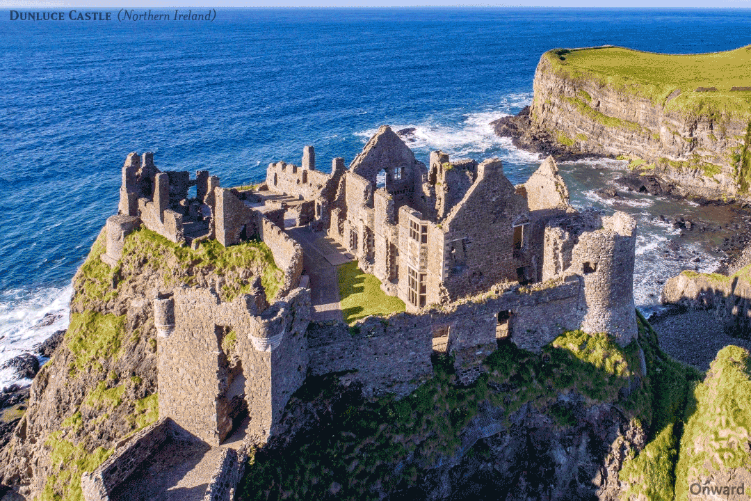
image from ancient.eu/uploads/images/12080.gif?v=1601385303
Hike Ireland / Walking Tours Ireland:
- Dunluce Castle – A circular 0.5mile walk from the car park to Dunluce Castle
77. Portstewart Strand (Refer to images on Game of Thrones Ireland Map)
The beach is owned and managed by the National trust. It is a 2 mile blue flag beach between Portstewart and the mouth of the River Bann. This is an area of natural beauty with a golden sandy beach and dominated by sand dunes. A great place to spend time with family and friends horseback riding, swimming, surfing or building sand castles. There are facilities onsite including a first aid station, toilets, outdoor showers and a small shop. There is an admission charge to enter the beach; income generated goes back into maintaining the beach.
Ireland Game of Thrones Film Location at Portstewart Strand
- Portstewart Strand – Coast of Dorne in the Faraway land of Dorne
- Season 5, Episode 4. “Sons of the Harpy”. Several scenes took place here in Episode 4:
- Jaime Lannister and Bronn of the Blackwater land in Dorne to rescue Jamie’s niece, Myrcella (his daughter by incest with Cersei), and bring her back to Kings Landing. Jaime and Bronn arrive on the beach on their way to save Myrcella
- They are discovered by Dornish Guards, and end up killing the 4 guards
- The location of the Sand Snakes who are Oberyn’s bastard daughters, Obara, Nymeria, Tyene and Ellaria. They discuss a plan for vengeance against the Lannisters when they find out that Jamie is in Dorne. They want to capture Mycella before Jamie can rescue her
- On the same sand dunes, Jaime and Bronn are attacked by the Sand Snakes
- Season 5, Episode 4. “Sons of the Harpy”. Several scenes took place here in Episode 4:
Hike Ireland / Walking Tours Ireland:
- Portstewart Strand Sand Dune & Estuary – Walk the beach with one of the tallest sand dunes in Northern Ireland. This 3.5 mile walk will starts at the beach entrance heading in the direction of Mussenden Temple in the distance. Walk along the beach towards the sand dunes and climb the wooden sand ladder. Follow the white marker posts to the estuary.
78. Downhill Strand / Beach (Refer to images on Game of Thrones Ireland Map)
This beach has been designated as both an Area of Special Scientific Interest (ASSI) and an Special Area of Conservation (SAC). The blue flag beach is part of an 11km stretch of sand and surf. There are a number of nature walks that include wildlife, waterfalls and sand dunes. In the backdrop of the beach and located on the clifftop, is the famous Mussenden Temple whose design is based on the Temple of Vesta in the Roman Forum in Rome, Italy. From the beach you can climb up to Mussenden Temple that has an outstanding view to the ocean.
Ireland Game of Thrones Film Location at Downhill Strand
- Downhill Beach is Dragonstone Island Beach. Downhill Beach served as the exterior filming location for Dragonstone Castle and for the beach at Dragonstone Island. Dragonstone Castle on the Island is a digitally altered computer enhanced image and does not exist in reality. Dragonstone Castle is superimposed on the cliffs above the beach
- Season 2, Episode 1. “The North Remembers”. Downhill Strand / Beach is used as the exterior scenes for Dragonstone Island. On the beach, Stannis Baratheon denounces the religion of the Westeros and embraces the Lord of Light during the burning of the statues of the Seven Gods of Westeros while Melisandre chants “For The Night is Dark and Full of Terrors”
- Season 2, Episode 2. “The Night Lands”. Where Davos tries to obtain the pirate lord Salladhor Saan assistance
- Season 3, Episode 10. “Valar Morghulis”. The beach is used when Ser Davos rescues Gendry and sends him away in a rowboat (see images on Game of Thrones Map above – click on the map pin of Downhill Beach)
Game of Thrones Film Locations:
Images of relevant Game of Thrones Scenes are on the Interactive map or PDF map above, click on the map pins
79. Mussenden Temple (Refer to images on Game of Thrones Ireland Map)
Built as a library by the Earl Bishop it is based on the Temple of Vesta in the Roman Forum in, Italy. The temple is perched at the edge of a 120ft cliff overlooking Downhill Beach. The temple is part of the Downhill Demense manor house which was built by Fredrick Augustus Hervey the 4th Earl of Bristol. Mussenden temple is north of the manor house with a path leading from the ruins of the house to the temple. Outside the temple is the inscription that reads “Suave, mari magno turbantibus aequora ventis e tarra magnum alterius spectare laborem” which means”Tis pleasant, safely to behold from the shore, the troubled sailor, and hear the tempests roar.” Mussenden Temple was used as a background for game of thrones.
Downhill Demense is currently managed by the National Trust. Downhill Demesne is a sprawling ruin atop a cliff. The Demense and Mussenden Temple is a spectacular site overlooking sandy Downhill Beach to the west and Castlerock beach to the east. It is possible to take the path and walk down to the beach however it’s a tough climb back up.
Ireland Game of Thrones Film Location at Mussenden
- Mussenden Temple
located on the Cliff of Downhill Beach has been digitally altered to look like
a Castle in the image of a dragon ie:Dragonstone Castle. Stannis Baratheon, the
younger brother of King Robert Baratheon was given Dragonstone Island and
Castle, which was the ancestral home of House Targaryen. The gift was a reward
for taking part in Robert’s Rebellion. The Castle is the backdrop in a number
of scenes in Season 2 and 3
- Season 2, Episode 1: “The North Remembers”. Burning of Seven Gods on Downhill Strand with Mussenden Temple as a CGI enhanced image of Dragonstone used as a backdrop on the cliffs above
- Season 2, Episode 2. “The Night Lands”. During Ser Davos conversation with Salladhor Saan on the beach at Dragonstone Island, the castle appears in the background
- Season 3, Episode 10. “Valar Morghulis”. As you watch Gendry escape from Dragstone Island on a rowboat, the Castle looms over the bay (see images and videos on Game of Thrones Map above – click on the map pin of Mussenden Temple)
Hike Ireland / Walking Tours Ireland:
- Portballintrae Causeway Loop– One of the longer walks at 5.5 miles. Start at the council car park at the end of Beach Road in Portballintrae and walk towards Giants Causeway. A scenic walk along the bay, on the clifftops, past Runkerry house and the Three Quarter Mile Bridge
- Mussenden Estate Walk – Start at the car park at the western end of the Tunnel Brae. This 3.6 mile circular walk will take you to the headland towards the lake and onto Mussenden Temple
- Mussenden Temple Downhill Demesne – A 2 mile walk starting at Bishops gate; there is a charge to enter the Demense. Explore the ruins of Downhill House and head to Mussenden Temple. The walk is on a private estate. The estate is part of the Binevenagh Area of Outstanding Natural Beauty
80. Binevenagh (Refer to images on Game of Thrones Ireland Map)
Binevenagh is an Area of Outstanding Natural Beauty where the ridge of the Mountain is the geographical edge of the Antrim plateau. The climb to the summit will reward you with gorgeous views of Lough Foyle and lush green pastures that stretch for miles.
Ireland Game of Thrones Film Location in Binevenagh
- Binevenagh is the Dothraki Grasslands, North of Meereen, Essos
- Season 5 Episode 10. “Mother’s Mercy” Drogon rescues Daenerys from Meeran fighting pits and brings her back to his lair. She wants to go back, however is exhausted and wounded and goes to sleep. Daenerys goes off in search of food and is spotted by three Dothraki riders. Soon after, she sees the horde advancing in her direction and drops a ring to the ground before being surrounded by the Dothraki horde and the khalasar. They eventually take her to Vaes Dothrak, the only Dothraki City in the Dothraki Sea on the continent of Essos
- Season 6 Episode 1 “The Red Woman”. Ser Jorah and Daario go searching for Daenerys in the same location and Jorah discover Daenerys’ ring. They go to Vaes Dothrak with a plan to rescue her. (In earlier seasons, Vaes Dothrak was filmed in the Mourne Mountains in County Down, Northern Ireland, however later seasons were filmed in Croatia)
Game of Thrones Door
Just a short distance away in Owen’s Bar, Limavady is Game of Thrones Door 5 showing scenes from episode 5 called “The Door”. The door focuses on the Night King and his followers, the Night Walkers.
- Door 5 Season 6 Episode 5: “The Door”, the carvings on the Door in Owens Bar focus on the dreaded Night King and his followers. On the door, notice that the White Walkers appear on both sides of the Night King and an army of undead Wight’s at his back. At the base is the House of Stark sigil which is interwoven in branches and roots, preparing for an attack.
Game of Thrones Film Locations:
Images of relevant Game of Thrones Scenes are on the Interactive map or PDF map above, click on the map pins
Hike Ireland / Walking Tours Ireland:
- Binevenagh Walk – A 3 mile circular walk from the car park on Leighery Road through the forest and to the summit of the mountain
81. Londonderry (Refer to images on the Ireland Attractions Map)
Londonderry is commonly referred to by its original name of Derry. It was forcibly rechristened as Londonderry in 1613 by a Royal Charter by King James VI of Scotland. Derry is located along the River Foyle and is the second largest city in Northern Ireland. The most distinguishing attraction is the largely preserved seventeenth century seven gate fortified wall system. It is the only completely walled city in Ireland with battlements, bastions, watchtowers, gates and big cannons. Visit the Guild Hall, Peace Bridge, the 1633 St Columb’s Cathedral and the 18th century craft village.
82. Pollnagollum Cave (Refer to scene images on Game of Thrones Ireland Map)
In Irish it means “Hole of the Doves” and it is located in the Belmore Forest 7th century fortified walls. The cave is part of the Marble Arch Caves Global Geopark, which are a maze of underground passages that attracts cavers from worldwide. For non-cavers there is a staircase that leads you to a viewing platform with a 12 meter waterfall.
Ireland Game of Thrones Film Location at Hollow Hill
- Pollnagollum Cave is Hollow Hill, it is used for exterior scenes of The Brotherhood without Banners’ hideout
- Season 3, Episode 2. “Dark Wings, Dark Words” Araya meets the brotherhood in the forest and they take her to their cave hideout
- Season 3, Episode 2. “Dark Wings, Dark Words” Araya meets the brotherhood in the forest and they take her to their hideout Season 3, Episode 5. “Kissed by Fire”. Sandor Clegane, The Hound, prepares to fight Beric Dondarrion in the cave as Arya and The Brotherhood look on
- Season 3, Episode 7. “The Bear and the Maiden Fair”. The caves are featured again where Arya flees from The Brotherhood and is captured by the newly released Hound who wants to return her to her family for a reward
Click on the map pins on the interactive or pdf map above for additional information including images and videos of the specific Game of Thrones Ireland Film Location or General attraction information
Hike Ireland / Walking Tours Ireland:
Pollnagollum Cave Walk – A fantastic circular 4.3 mile walk starting from the car park and into the Belmore Forest with a stop at the cave viewpoint and waterfall
83 – 93 Ireland Attractions (Game of Thrones Ireland Door 1 – 10)
Please refer to Game of Thrones Ireland Map Black Map pins – indicating the location and information for each door in Episode 6
How To Visit Ireland
Northern Ireland Public Transportation:
- By Bus
- For both bus and rail, this Journey Planner has all the options available
Rambler Bus Service
From May to August, Translink operates the Rambler Bus Service to take you to Start and End locations of many of the walking paths in the Mourne Mountains. Another option is the Mourne Shuttle Service (AIMSS) that is available all year round
- By Rail
- For both bus and rail, this Journey Planner has all the options available
By Car
Not all the attractions are accessible by public transportation. For some attractions, you may need to rent a car or take a tour
Additional Ireland Attraction Guides:
- Getting around Ireland – Using Public Transportation in Ireland
- Cliffs of Moher – A very popular tour, a complete guide to the 16 attractions along the Cliffs of Moher Coastal Walk
- Doolin – A quaint popular village in County Clare. Stop overnight and walk to the Cliffs of Moher from Doolin or enjoy the many other attractions in and around Doolin
- The Ring of Kerry – A spectacular 111 mile scenic route on the Iveragh Peninsula. Start at either Kenmare or Killarney for a circular route of three hours without stops. Jaw dropping views of the Atlantic ocean, charming villages and wild sweeping mountains makes this a popular must see attraction in Ireland. Use the map and attractions for the complete self guided tour of the Ring of Kerry
- The Dingle Peninsula – It is a 30 mile long clockwise loop that takes about 4 hours to complete. The area is the bedrock of Irish culture with signs in many villages and towns indicating that Irish is the predominant language in the area. The picturesque landscape includes rolling hills, craggy shorelines and sandy beaches. The PDF map and attractions guide explores the attractions of the Dingle Peninsula
- The Ring of Beara – An 85 mile circular route, similar to Ring of Kerry and Dingle Peninsula, however it is far less travelled. In that sense, it is a better drive as there are far less cars on the road. I found the Ring of Beara far more dramatic than either the Ring of Kerry or the Dingle Peninsula. It is not as popular because the tourist buses are not able to navigate the narrow roads with hairpin bends or the Healey Pass.
- Dublin: Explore central Dublin on foot with these three self guided walking tours and map:
- Dublin Walk 1 – Top 18 Attractions, guide to Dublin City Center, North of the River Liffey Dublin
- Dublin Walk 2 – Top 16 attractions, guide to attractions South of the River Liffey, including the Temple Bar Region
- The Book of Kells and Trinity College in Dublin. Trinity College is the oldest university in Ireland with the historic Long Room,and the old library with over 200,000 of the very old books. It is the most impressive library in the world
- In Dublin visit the Little Museum of Dublin, Grafton Street, St Stephens Green and Kilmainham Goal (the prison where many rebels from the Easter Rising were held before their execution)
- Dublin Walk 3 – Top 16 attractions, guide to Historic Old Dublin
- Galway – Use the Galway Ireland guide for a flexible and personal tour of over 40 attractions Galway City
- Aran Islands – For a truly authentic Irish experience visit the Aran Islands. They are located at the mouth of Galway Bay. You can catch a ferry from either Doolin or Rosseeval port (Shuttle from Galway to Rosseeval ferry port)
- The Glens of Antrim – Driving route for the nine Glens of Antrim in Northern Ireland. The guide includes options for public transportation, walking trails in The Glens and Game of Thrones Attractions
- Over 100 Northern Ireland Attractions – Visit over 100 attractions along the east and north coast of Ireland along the Antrim and Causeway Coastal Route. Travel by car or public transport from the Mourne Mountains to Londonderry. Includes game of thrones sites, castles and walks along the route
- The Burren – Explore the karst moonscape bedrock of The Burren located in the southwest region and close to the Cliffs of Moher. Attractions in the Burren include ancient tombs, underground caves, walks on an unusual landscape and The Burren National Park