Cliffs of Moher Map, Self Guided walking tour
What are the Cliffs of Moher in Ireland
The Cliffs of Moher are one of the most spectacular exposed cliffs in Ireland and the Cliffs of Moher Coastal Walk is a 14 kilometer walk along the clifftops. The Cliffs of Moher Coastal Walk has several viewpoints, car parks and entrances and attractions such as Hags Head and O’Brien’s Tower. Looking out to the Atlantic sea the exposed cliffs with horizontal striations or layers are easy to see on the Cliffs of Moher Coastal Walk
How were the Cliffs of Moher Formed?
Each striation or layer is of different thickness. These represent a deposit of sand and sediment and each striation or layer is a separate cycle of deposit. The thicker the striation, the greater the deposit at that time. Think of each layer as a chapter in the lifecycle of the Cliffs and together they make up a historical time line. The deposits started over 300 million years ago when the area was a marine basin at the mouth of a river. As the river entered the basin and continued its journey towards the sea, it dropped layers of sand, mud and silt.
As deposits continued over millions of years, the bottom layers compacted under the weight of the new deposits. The compaction of the bottom layers formed bands of sandstone, mudstone and siltstone. Each rock layer represents a specific event eg: a massive storm/flood dropping a layer of sand. The layers vary in thickness from centimeters to meters and the combined height of these layers is 214 meters, the height of the Cliffs of Moher, and a length of 14 Km Cliffs of Moher Coastal Walk. Though not the highest cliffs in Ireland which are the Slieve League in Northwest Ireland and Croaghuan cliffs on Achill Island they are spectacular
Cliffs of Moher Geology
If you happen to be at the base of the cliffs on a Cliffs of Moher Cruise Tour, take a close look at the layer and you may see fossils embedded into the striations. These are remains of marine life that existed when the layers were buried by the sea. Changes in sea level and movements of the earth eventually exposed the area. Over time retreating glaciers, powerful winds, rain and wave actions eroded the cliffs. Erosion over the millennium exposed the cliffs. The Cliffs are continuing to be eroded
Where are the Cliffs of Moher in Ireland
The Cliffs of Moher are on the western coast of Ireland in County Clare. They are adjacent to the Burren region and stretch 14km along the coast line. The village of Doolin is 7 km north of the Cliffs of Moher visitor center and Liscannor is 6km south of the visitor center. They are 270 km and 3 hour drive from Dublin and you can visit them on a day trip from Dublin by car or tour or an overnight trip by public bus
Cliffs of Moher Map, Attractions on the Cliffs of Moher Coastal Walk
Click HERE to download the interactive Cliffs of Moher Coastal Walk Map
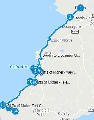
Click HERE to download the PDF Cliffs of Moher Coastal Walk Map
This post contains affiliate links. That means that I may earn a commission if you make a purchase though one of these links.
Using the Cliffs of Moher Map for your personal tour of the Cliffs of Moher Coastal Walk
Use the map above and the self guided tour below and follow the route. The attractions are listed from 1-17 on the attractions guide below and on the map above. Pick your starting point and create your own personal tour on the Cliffs of Moher. Click on the map to download an interactive map. On the interactive map, click on the map pins for additional information for each attractions plus images and/or videos
Ways to Visit the Cliffs of Mohr
- Self guided tour using the information below. This includes a map, attractions guide and parking information
- Book one of the popular tours for trips to Cliffs of Mohr, nearby Galway, Aran Islands and the Burren. Tours include pickup, transportation and are conducted by local guides.
- Take a cruise around the Cliffs of Mohr and visit one of the Aran Island.
Are the Cliffs of Moher Ireland Free
The Cliffs of Moher Coastal Walk is free to access, however parking is not free. So if you park your car at the designated entrance or on private farm lands then you will have to pay to park. Some car parks are per person to park and others are per car
You can park your car in Doolin village and take the shuttle to one of the designated entrance to the cliffs, or take the Doolin ferry or a Cliffs of Moher Cruise to visit the Cliffs from the sea. You can also park your car at Liscannor village or Liscannor car park and access the cliffs from those entrances which are to the south of the Visitors Center. Each of these activities have an associated costs
There is a cost to enter the visitors center, if you park your car at the base of the visitor center, the parking cost includes entrance fee to the visitors center.
Cliffs of Moher Car Entrance
The Cliffs of Moher is on private farmland, however there is public access along predefined paths along the cliff tops as a result of Irelands ancient right of ways. There are several entrance points to the Cliffs of Moher Coastal Walk path along the cliff tops. This includes:
- Park your car in Doolin at Fisher Street Car park. Walk south along Fisher Street towards the Cliffs of Moher. Doolin is at sea level so you will be walking uphill towards the cliffs
- Park your car at the Cliffs of Moher Visitors Center; the cost to park is per person; which includes access to the visitor center. Close to the visitor center is O’Brien’s Tower; at the base of the Tower is the highest point on the cliff at 214m above sea level
- Guerins Path is a car park on private farm land. The farmer allows access to his land where there is a paved parking lot and washroom facilities. The cost to park is per person it is cheaper than the visitor center and the cliffs are a very short walk from the car park and you are at the top of the cliffs
- Liscannor Car Park is another car park where you can park your car on private farm land and walk about one kilometer on a predefined path towards the Hags Head on Cliffs on Moher Coastal Walk path. You will start the cliff walk by walking north towards the visitor center. The height at this location is 130 meters above sea level. Please note that locals refer to this as Kilconnel car park and it is labelled on Google Maps as Cliffs of Moher Liscannor Walk
Cliffs of Moher Car Entrance
You can park at one of the car parks listed above and walk the Cliff of Moher Coastal Walk designated by a specific walking paths. Alternatively you can take a shuttle bus from Doolin to one of several designated spots or entrances to the Cliffs of Moher Coastal Walk and access the path from there. The shuttle buses have a selected parking spot in Doolin where you can park your car and take the shuttle. To return to the car park, take the return shuttle bus at another designated shuttle bus spot. This allows you to get dropped off at one location, walk along the Cliffs of Moher Coastal Walk until you are tired and get picked up at a different selected location. Keep in mind the shuttle schedule and pickup/departure times
There are two companies that run shuttle buses:
- Paddywagon Tours – purchase tickets by emailing the company at [email protected]
- Cliffs of Moher Shuttle bus schedule – tickets can be purchased online HERE
Cliffs of Moher in crazy weather; video below
Cliffs of Moher Ireland Things to do and see
- A haven for birds and a treat for bird watcher with about 30,000 birds using the cliff as a breeding ground:
- you will find large numbers of puffins in May and June
- razorbills, kittiwakes and
- peregrine falcons
- Looking out for breaks or ripples in the water, they may be a Shark or Dolphin Pods
- Walk along the cliff paths, visit the Visitor Center
- Recently the Cliffs have become a big attraction for surfers who come to catch the big waves
- Climb O’Brian’s Tower
- Discover the Karst landscape of the Burren
- Explore the villages of Liscannor at the south end
- Stop at the village of Doolin at the North End of the Coastal walk
- Visit the Doolin Caves
- Take a ferry from the Doolin Pier to the the Cliffs of Moher or to the Aran Islands
- Take a boat cruise from Doolin to the Cliffs of Moher
Best Time to Visit the Cliffs of Moher
The cliffs are one of the top two attractions in Ireland and get very crowded during the summer months from June to August. The Guinness Store house in Dublin is the top attraction in Ireland. If you want to avoid the high season tourist crowds, its best to visit in the shoulder season either April/May or Sept/Oct.
You may also avoid peak periods in the day which tends to be between 10 am and 3pm when the Cliffs of Moher Coastal Walk is crowded, especially close to the visitors center where the crowds seem to gather. A visit after 4pm will reward you with beautiful sunsets along the cliff walk
Cliffs of Moher Safety
Coastal erosion continues at the Cliffs of Moher where waves break against the base of the cliff loosening the sediment and depositing it into the sea. The eroding base results in hanging cliffs that do not have a stable base and occasional the hanging cliff edge falls into the sea. Stay on the designated Cliff of Moher Coastal Walk path and avoid getting close to the edge as it is not always stable
The winds can really pick up along the top of the cliffs and it very easy to get blown down by the winds. Hang on to young children and keep your feet firmly planted on the ground. Ireland has developed a warning system; check the weather before you go
- Status Yellow – indicates hazardous conditions on the cliff and you are urged to exercise extreme caution. There are strong winds that could knock you off balance or carry you off the cliff
- Status Orange – Unsafe conditions, it is too hazardous to visits the cliffs. If you happen to be on the cliffs at this time, the visitor center will be open during regular hours as a refuge from the weather and you can take shelter there
- Status Red – Sever weather, avoid the cliffs. The visitor center will be closed and under no circumstances should you visit the cliffs
Irish weather can change quickly, bouts of sunshine are quickly replaced with short torrential thundershowers, strong winds created by wind tunnels or the fog rolls in very fast and you cannot see what’s in front of you. Stay vigilant and alert
Cliffs of Moher Coastal Walk
The cliffs are continually experiencing erosion. Waves crash against the base of the cliffs, destabilising the base and causing the top of the cliffs to fall under its own weight into the sea below.
You will find that there are two paths along the top near the visitor center. There is an official path that is set back a little from the edge and there is an unofficial path that is closer to the edge of the cliff. It is advisable to stay on the official Cliffs of Moher Coastal Walk path there have been reported serious injuries, falls and fatalities on the cliffs. Follow the rules and exercise good judgement
The entire coastal walk is about 20km and the cliff walk is about 14km. It is 8 km and a 2.5 hours walk from Doolin to the Cliffs of Moher Visitors Center and another 6 Km from the Cliffs of Moher Visitors Center to Hags Head
If you are planning on walking on the paths, wear good comfortable, waterproof shoes or hiking shoes, wind, rain or waterproof jacket and dress for the weather. It can get wet and wind. Wind gusts are common. Sunscreen, water and binoculars are helpful.
Start of Cliffs of Moher Ireland – Self Guided Tour
Use the Cliffs of Moher map above and follow the route. The attractions are listed from 1-16 on the attractions guide below and on the map above. Pick your starting pont and create your own personal tour on the Cliffs of Moher
1. Doolin Village
A charming seaside village and the Celtic music capital of Ireland and home to Irelands growing surfer community
2. Doolin to Cliffs of Moher Coastal Walk
Park your car at Doolin and walk along Fisher Street for the Doolin Coastal Cliff Walk. You will be starting at sea level and walking uphill at a height of 214 meters at the visitor center.
Alternatively you can park your car at Doolin and take a shuttle to the Visitors center. From the Visitors center you can walk north downhill about 6km to Doolin Village or walk south about 4.6 km from the visitors center to Hags Head. Then catch the shuttle bus back from Hags Head to Doolin. You can also walk from Doolin all the way south to Hags head and back to Doolin for a total round trip of about 20 km
3. Viewing Point on the Doolin Walk
A designated view point at the Cliffs of Moher Coastal Walk
4. O’Briens Tower
Cornelius O’Brien, a descendent of Brian Boru, the High King of Ireland was a local landowner who lived at Birchfield House in Liscannor. He was the first to take advantage of the majestic views at the Cliffs of Moher. Cornelius built a 30 foot tower with a teahouse at the highest point on the cliffs in 1835 to attract visitors to the area. He also built the flagstone wall you see along the cliffs. A charitable man, he was a member of the Liscannor Famine Relief Committee providing work to the tenants whose crops had failed. He was a member of parliament for 20 years and after his death the tower eventually fell into disrepair. In 1978 it was restored with a small visitors center which was eventually replaced with the new one you see today in 2007. For a small fee you can climb the tower for an even higher view of the Atlantic ocean and the attractions around the cliffs. This tower is both the mid-point and also the highest point on the Cliffs of Moher Coastal Walk
5. An Branán Mór, The Branaunmore Sea Stack
From O’Brien’s tower you will see the 67 meter high sea stack. It is 200m below O’Briens tower and about 60 meters out to sea. The sea stack is 67 meters high and was originally part of the mainland. However relentless waves, wind and ice over millions of years eroded the land between the sea stack and the mainland leaving the tall columnar stone stack jutting out of the sea. In 1990, Nikki Duggan, Mick Fowler and Steve Sustad climbed the northwest corner of the stack and it is the only recorded ascent to date
6 – 9. There are a number of viewing points near the visitors center at the Cliffs of Moher
- The Main Platform
- The Main viewing platform near the visitors center will allow you a great view to the south towards Hag’s Head.
- The North Platform is close to O’Brien’s Tower and is the highest point of the Cliffs at 214m.
- You will be able to see the An Branán Mór Sea Stack just below you. Razolbills tend to nest at the lower end of the sea stack while the Kittiwakes nest at the upper sections of the sea stack
- If the weather conditions are favorable for surfing, to the right you may be able to see the famous surf wave referred to as “Aileen” or Aill Na Searrach.
- To your left is Galway Bay.
- Straight across, on a clear day you will be able to spot the three Aran Islands: Inis Méain , Inis Oírr and Inis Mór
- From here you will have a great view of the Cliffs to the south with extend out 8 kilometers to Hags Head and 5 Kilometers to the north to Doolin
- The South Platform
- There are about 30,000 seabirds that call the Cliffs of Moher Home. The largest colony of Puffins with about 1,365 found here. They nest underground or on the grassy summits of Goat Island. In the winter they go out to the sea but return from May to July to nest. From the south platform you will get a great view of the puffin colony, look down and to the right towards Goat Island
- From here you can continue 4 kilometers towards Hag’s Head
10. Burren & Cliffs of Moher Geopark UNESCO Global Geopark
The Geopark includes both the Cliffs of Moher and the Burren National Park which is adjacent to and just to the north of the Cliffs. Burren means great rock
A UNESCO designated area of geological interest. It is the third Geopark to be designated in Ireland. It is recognized by at both European and global levels
11. Cliffs of Moher – Telescope
12. South Viewpoint Cliffs Of Moher Coastal Walk
A designated view point at the Cliffs of Moher
13. Guerin’s Path – car park
This is a car park on private land. You can park your car here and pay a fee based on number of people. It is a per person fee not per car. The car park has washroom facilities and is just a few minutes from the cliffs so you do not have to walk to get to the cliffs. Once you are at the cliffs you can begin your Cliffs of Moher Coastal Walk by either walking south for 4 km to Hags Head or 2 km north to the Visitors center
14. Hag’s Head
At the southern end of the coastal walk Hags Head juts out towards the sea. Here you will see an outcrop of stacking stones that look like an old woman sitting and looking out to the sea. It is said that a hag, defined as an ugly old woman, followed her the man she loved across the cliffs. She was trying to catch up with him as he was running away from her. She missed a stepping stone and fell into the seas. The point where she fell is referred to as Hag’s Head
15. Moher Fort Site (at Hags Head)
Moher tower located at the southern end of the Cliffs of Moher Coastal Walk at Hag’s Head. It was built on an old promontory fort called Mothar or Moher. The fort dated back to the 1st century and was still in place as early as 1780. However, by 1808 the fort was demolished to provide materials for a lookout tower. The lookout tower was built during the Napoleonic war and was intended as a watchtower providing warning in the event of a French invasion war. Today it is almost a square stone ruin tower. It has a fireplace and at least two floors with a stone roof. Its main occupants are birds native to the area or those seeking shelter from a sudden storm as they travel over the Atlantic Ocean
16. Walk from Liscannor Car Park
Park on a farmer’s field at Liscannor Car Park (yellow house with paved parking lot). Much cheaper to park than Guerins’s car park or Cliffs of Moher Visitor Center. The car park is paved however to get to it you will have to drive on narrow minor roads and pull over as cars come in the opposite direction. The cost is per car (not per person). It is a 800 meters pleasant walk to the Cliffs of Moher. The video on the Cliffs of Moher map shows the walk from the car park to the edge of the cliff where you can begin the cliff coastal walk. You will walk north towards the visitors center. The visitors center is about 4.6 km away on the cliff walk but it will take you about one kilometer to get from the car park to the cliff edge
17. Liscannor Car Park
Map pin #17 on the Cliffs of Moher map above shows the image of the Liscannor Car park
Dublin to Galway
- You can get to Galway by Irish rail from Dublin’s Heuston station or by bus using Gobus.ie. Aside from car rental, these are two popular ways for getting to Galway from Dublin.
- You can also use Bus Éireann instead of Gobus.ie. Use the journey planner for public transportation. In the planner, select Dublin station to Galway station for the different options
- The journey planner is for all of Irelands public transportation (not Gobus.ie as its privately operated). The planner will give you rail and bus options or a combination for travel in Ireland
- Galway to Cliffs of Moher by bus:
- From the Galway main bus station at Eyers Square, take Bus Eireann 350 (Take the bus in the direction of Ennis, towards Ennis). The bus stops at the visitors center at the Cliffs of Moher Coastal Walk on its way to Ennis. The journey from Galway to the Cliffs of Moher by bus is just over two hours
Galway to Cliffs of Moher
It is approximately 2 hours from Galway to Cliffs of Moher Coastal Walk. The roads are well signposted
- Galway to Cliffs of Moher by car:
- Direct route by car from Galway to Cliffs of Moher:
- From Galway, take the N67 to Lisdoonvarna. At Lisdoonvarna take R478 to Cliffs of Moher
- Scenic Route by car from Galway to Cliffs of Moher:
- If you want to take a more scenic route along the coastline you should take N67 from Galway to Ballyvaughan then turnoff onto R477. This will add 30 minutes to your journey, however it will take you into the Burren and around Galway Bay. The Ballyvaughan turn off is well before Lisdoonvarna
- Direct route by car from Galway to Cliffs of Moher:
- As you approach the Cliffs of Moher you will need to slow down due to the number of walkers on the road. If you are planning to park at the visitors parking lot, it is on your left
- In Galway you can either spend the night or continue onto Doolin or Liscannor. Aside from the Cliffs of Moher Car Park(Visitor Center), Doolin and Liscannor are the two closest places to the Cliffs of Moher Coastal Walk. From Galway, you will need to take Bus Eireann 350 (towards Ennis) from Eyres Square in Galway which travels to Liscannor (south of the cliffs), Doolin (north of the cliffs) or directly to the Cliffs of Moher Visitors Center
- Aside from car rental, these are detailed public modes of transport:
- When you get to Galway, use the Galway city bus map to explore Galway
- Favourite daytrips from Galway include the Cliffs of Moher Coastal Walk, Doolin Village, The Burren and Aran Islands
- Galway to Cliffs of Moher, (public transport Bus Eireann route 350 towards Ennis to Cliffs of Moher Coach Park)
- Galway to Doolin, (public transport Bus Eireann route 350 towards Ennis to Doolin Hotel. Explore Doolin village and walk from Doolin village to Cliffs of Moher Cliff Walk
- Galway to Aran Islands, (public transport Bus Eireann route 424 to Rossaveal Ferry port), then catch the ferry from Rossaveal to Aran Islands. Additional information can be found at the Aran Islands ferry website HERE
- Galway to The Burren, take Expressway Bus 51 in Galway’s Eyre Square (bus stop 635341), and travel 9 stops to Ennis Station (Bus stop 635341). It will take about 1.5 hours to get to Ennis Station. At Ennis Station, take Bus Éireann 333 and travel 5 stops to the village of Corofin. It will take about 30 minutes to get to Corofin. Disembark at Corofin and walk 2 minutes to the Burren National Park Information center in Corofin. There is a free shuttle bus that goes to the park. There are additional public transport options to The Burren from Limirick, Shannon, Cork, and Cliffs of Moher
- A list of walking trails in the Burren National Park
- If you are driving to the park, parking at the park is very limited and it is advisable to park at the information center in Corofin and take the free shuttle bus to the park
- Aside from car rental, these are detailed public modes of transport:
- Use the following Journey Planner to plan you bus route
Dublin to Cliffs of Moher Coastal Walk
- By Car Dublinto Cliffs of Moher Coastal Walk:
- It is a 3 hour journey from Dublin to Cliffs of Moher. From Dublin, take the R148 then turn off on the N4 then onto to the M4. From M4 take the M6 turnoff to Galway. Then follow the directions in the previous section for Galway to Cliffs of Moher. The roads are well maintained and signposted
- By Bus Dublinto Cliffs of Moher Coastal Walk:
- It will take you a day to travel by bus from Dublin to Cliffs of Moher, anywhere from 9 to 11 hours. You will need to travel to a village close to Cliffs of Moher or to Galway. Spend a night or a few nights there then visit the Cliffs of Moher in the morning
- Two villages close to the Cliffs of Moher are Liscannor (to the south of the Cliffs) and Doolin (to the north of the Cliffs)
- From Dublin to Cliffs of Moher by bus, you will need to go to Galway first.
- To get to Galway from Dublin:
- By train from Dublin to Galway Dublin using Irish Rail from Irish rail from Heuston station in Dublin to central Galway, it takes about 2.5 hours and has 8 stops along the way dropping you off at Cleannt Station in Eyre Square, Galway
- By bus from Central Dublinto Galway or Dublin Airport using either:
- From Dublin, you can also get to Galway by using Gobus.ie. Gobus will take you from Dublin to Galway
- To get to Galway from Dublin:
- This is my favorite journey planner for all of Irelands public transportation, click HERE. The planner will give you rail and bus options or a combination for travel in Ireland
Is there a train from Dublin to Cliffs of Moher Coastal Walk?
There is no direct train from Dublin to Cliffs of Moher. From Dublin Heuston Station you can take the train to Galway (Ceannt) Eyes Square. From Galway Eyes Square take Bus Éireann #350 (towards Ennis) which will stop at Cliffs of Moher visitors center (car gate). This will take approximately 6 hours
Limerick to Cliffs of Moher Coastal Walk:
- Driving from Limerick to Cliffs of Moher is 1 hour and 5 minutes
- By Bus: From Limerick main bus station take the bus Éireann #300 to Ennis. In Ennis take #350 bus to the Cliffs of Moher Visitor Center (car gate). It will take you about 3 hours travel time
Other Attractions in Ireland
Use the Getting around Ireland guide to visit Over 100 Attractions in Ireland (including Games of Thrones Film locations) or The Glens of Antrim
Additional Ireland Attraction Guides:
- Getting around Ireland – Using Public Transportation in Ireland
- Cliffs of Moher – A very popular tour, a complete guide to the 16 attractions along the Cliffs of Moher Coastal Walk
- Doolin – A quaint popular village in County Clare. Stop overnight and walk to the Cliffs of Moher from Doolin or enjoy the many other attractions in and around Doolin
- The Ring of Kerry – A spectacular 111 mile scenic route on the Iveragh Peninsula. Start at either Kenmare or Killarney for a circular route of three hours without stops. Jaw dropping views of the Atlantic ocean, charming villages and wild sweeping mountains makes this a popular must see attraction in Ireland. Use the map and attractions for the complete self guided tour of the Ring of Kerry
- The Dingle Peninsula – It is a 30 mile long clockwise loop that takes about 4 hours to complete. The area is the bedrock of Irish culture with signs in many villages and towns indicating that Irish is the predominant language in the area. The picturesque landscape includes rolling hills, craggy shorelines and sandy beaches. The PDF map and attractions guide explores the attractions of the Dingle Peninsula
- The Ring of Beara – An 85 mile circular route, similar to Ring of Kerry and Dingle Peninsula, however it is far less travelled. In that sense, it is a better drive as there are far less cars on the road. I found the Ring of Beara far more dramatic than either the Ring of Kerry or the Dingle Peninsula. It is not as popular because the tourist buses are not able to navigate the narrow roads with hairpin bends or the Healey Pass.
- Dublin: Explore central Dublin on foot with these three self guided walking tours and map:
- Dublin Walk 1 – Top 18 Attractions, guide to Dublin City Center, North of the River Liffey Dublin
- Dublin Walk 2 – Top 16 attractions, guide to attractions South of the River Liffey, including the Temple Bar Region
- The Book of Kells and Trinity College in Dublin. Trinity College is the oldest university in Ireland with the historic Long Room,and the old library with over 200,000 of the very old books. It is the most impressive library in the world
- In Dublin visit the Little Museum of Dublin, Grafton Street, St Stephens Green and Kilmainham Goal (the prison where many rebels from the Easter Rising were held before their execution)
- Dublin Walk 3 – Top 16 attractions, guide to Historic Old Dublin
- Galway – Use the Galway Ireland guide for a flexible and personal tour of over 40 attractions Galway City
- Aran Islands – For a truly authentic Irish experience visit the Aran Islands. They are located at the mouth of Galway Bay. You can catch a ferry from either Doolin or Rosseeval port (Shuttle from Galway to Rosseeval ferry port)
- The Glens of Antrim – Driving route for the nine Glens of Antrim in Northern Ireland. The guide includes options for public transportation, walking trails in The Glens and Game of Thrones Attractions
- Over 100 Northern Ireland Attractions – Visit over 100 attractions along the east and north coast of Ireland along the Antrim and Causeway Coastal Route. Travel by car or public transport from the Mourne Mountains to Londonderry. Includes game of thrones sites, castles and walks along the route
- The Burren – Explore the karst moonscape bedrock of The Burren located in the southwest region and close to the Cliffs of Moher. Attractions in the Burren include ancient tombs, underground caves, walks on an unusual landscape and The Burren National Park