The Burren Ireland Map and Top Attractions
The Burren Things to do
- Visit Aillwee cave. Get some “take out” lunch in Ballyvaughan and pop over to Fanore beach for a picnic
- Use the Burren Ireland Map to explore the Burren region of Ireland, visit Cocomoroe Abbey on Abbey Hill Walk (walk from Bell Harbour)
- Experience medieval Ireland at stone fort and poulnabrone, This is the most visited Burren Ireland Attractions
- Hiking kayaking swimming surfing, cycling and horseback riding in the Burren
- Walk the Cliffs of Moher
- Walking trails including Black Head Loop Trail and the Burren Way of Ireland
- Take The Burren shuttle to Burren National Park
Download The Burren Ireland Map HERE
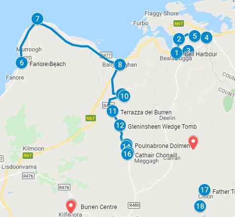
Download The Burren Ireland in PDF map Here
Using The Burren Ireland Map (items 1 -19 below)
The Burren Ireland map above lists the most popular attractions in The Burren. Download the PDF Burren Ireland Map or Interactive Map to create your won personalized tour of The Burren Region. Click on the blue map pins for additional information, images and videos of the attractions
1 – 2. Bell Harbour & St Patrick’s Church
The small village of Bellharbour, also known as Bealaclugga, or Béal an Chloga in Irish, is east of Ballyvaughn Bay
3. Corcomroe Abbey
The second stop in the Burren Ireland Map is The Abbey. The Abbey is surrounded by the bare grey landscape of the Burren hills, was founded for Cistercian monks around 1195 and is inland from Bellharbour. It was founded by Donal Mór O’Brien in 1194. Donal Mór O’Brien and Conor O’Brien are buried onsite, near the north wall. The former Cistercian abbey is located within its own small valley surrounded by low hills. The church was built in the 13th century and the altar has some of the finest stonework in Ireland. It was never fully completed, perhaps due to insufficient funding and its decline began in the 15th century. Access to the Abbey is via Corcomroe Rd and it is also very close to L1014 road
4 – 5. Abbey Hill Summit and car park, Directions and images on the Burren Ireland Map
Abbey Hill is named after the Abbey, which is located on the south side of the summit. You can walk to the summit from the car park listed as item #4 on the map above. It is 240meters high with spectacular views out to the bay and the small village
The Burren Karst landscape
The hike to Abbey Hill summit is within the karst landscape of the Burren region of Ireland. Often tourists are looking for the Burren not realizing that they are within the Burren. The Burren is about 380 Square Kilometers
- Head to the car park (item 4 on the interactive Burren Ireland map above) and take the pathway up to the Abbey Hill
- Close to Bell Harbour is St Patrick’s Church. For a great walk in the Burren, there is a path behind St Patrick’s Church that takes you north along Abbey Hill
- You can also take a walk along the green road that encircles Abbey Hill. The access to this road is behind the New Quay Church
- If you want to walk in the Burren on the Burren Way trail, there is a Map HERE of the 112 km trail broken out by sections
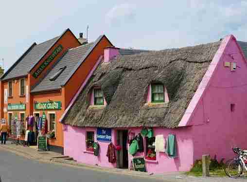
6. Fanore Beach
A blue flag beach close to Fanore village that is very popular with locals. Fanore lies between the villages of Ballyvaughn and Doolin at the mouth of the Caher River. A large sandy beach with clear waters and an extensive sand dune system called “Rabbit Warren”. Activities in the area include walking, fishing, surfing, swimming and rock climbing. Rock climbing is available 6km north at Ailladie cliffs. These cliffs are also known as Ballyreen Cliffs and Ballyreen Point and are a popular attraction with views of the Aran Islands. The 800m long cliffs varies in height from 8 meters to 35 meters and is a popular rock climbing spot in the area. Fanore Beach is one of 9 locations that is of geological importance and together forms the basis of The Burren and Cliffs of Moher Global Geopark. Interestingly Fanore Beach has appeared on the television series father Ted several times
Fanore to Ballvaughn Trek
Hike in the Burren, which is known for its unique fauna and flora as well as its unusual landscape. Starting at Fanore beach walk to Blackhead Lighthouse and even further on the same route onto Ballyvaughan. The walking route in the Burren is HERE
7. Blackhead
The Blackhead lighthouse was the first lighthouse to be built in Galway Bay. It is part of the Burren region and surrounded by typical Burren lunar landscape in Ireland distinct smooth rocks and gullies known as ‘grykes’. The grykes are full of flora many characteristic of the Burren such as the maiden fern. There is no official car park, and cars are parked in the layby. The Black Head Loop Walk is a 26 km begins from Fanore Beach along the coast around Black Head via Green Road.
A map of the Blackhead loop walk (from Fanore to Blackhead lighthouse and to Ballyvaugh can be found HERE. This map shows the elevations along the 26 km route
8. Ballyvaughan
The next stop on the Burren Ireland Map is Ballyvaughan. The small village of Ballyvaughan is located along the south shore of Galway Bay with a harbour and 50m Pier. From April and September the village hosts a great farmers market on Saturdays and a craft fair on Sundays
9. Bird of Prey Center
The center is home to one of the largest collection of Birds of Prey in Ireland including falcons, eagles, hawks, vultures and owls. You can book a walk with a hawk. It allows you the opportunity to handle a hawk, walk with it, feed it, release the hawk and watch it fly away and come back to you. More information on the Birds of Prey center can be found HERE
10. The Aillwee Cave
The Aillwee cave is located in the karst landscape of Burren region of Ireland. The hills behind the caves contain fossils daring back 300 million years. The cave itself is said to have been formed during glacier advance and retreat more than a million years ago. The rain water flowed through the cracks into the limestone below ground dissolving the limestone and creating the one kilometre cave system into the heart of the mountain
Aillwee is Irish for Aill Bhui which translates to “yellow cliff”. The accidental discover of the cave system in 1944 was by Jack McGann and his dog. Jack, a farmer followed his dog who was chasing a rabbit. The rabbit disappeared into the side of a hill. Upon further exploration Jack discovered the cave, however he did not venture very far into the cave as the passage was blocked by a pile of boulders. He did not make his discovery public until 1973 when he informed some enthusiastic cavers. In 1977 the boulders blocking the passage were removed and in 1992 some of the cave was blasted to create a circular passage
Discovery in the cave included:
- 10,000 year bones from two bears, at this time only 1,000 people lived in Ireland. Bears have been extinct in Ireland for 1,000 years
- Remnants of a subterranean river, currently filled with glacial till
- An underground waterfall
- Large Stalagmites – a tall columnar limestone formation rising from the ground
- Large Stalagtites – a tall columnar limestone formation hanging down from the ceiling
The cave is on private land and open to the public however only one third of the cave, 300 meters, is accessible to the public, exit is via a man made 250 meter tunnel
Things to do in the cave
- Tours of the cave
- Hawk Walk – a Falconry workshop for all ages. Handle a falcon yourself, set it loose and have it come back to you over a 45 min walk in the forested area
- Hazel Wood Walk
- Visit the Wolf Den
In the episode of Father Ted in which the gang depart Craggy Island and embark on an adventure of sorts to the mainland. While on the mainland, Ted and Dougal decide to visit some caves known as the Very Dark Caves and have a disastrous encounter with Richard Wilson from One Foot in the Grave.
Father Ted episode youtube https://youtu.be/vAuDDj4Erpk
How to Getting to the cave
- Bus 350 to Ballyvaughan then a 4 minute taxi to Alliwee cave
- Use this journey planner to plan your public transportation route.
12. Gleninsheen Wedge Tomb located in the Burren Ireland Map
Just off the R480 out in a farmer’s field on private property are two prehistoric early Bronze Age wedge tombs. Dating back to about 3000BC. The tomb is next to the road just over a low stone fence. One of the tombs is next to the road. The other tomb is about 100m to the northeast and is partially collapsed
The burial chambers of Wedge tomb narrows at one end in both width and height hence the name wedge tomb They are so named because the burial chamber narrows at one end and the widest part faces southwest towards the sun
13 – 14. Poulnabrone Dolmen
The second most visited monument in the Burren, it is also the oldest megalithic monument in Ireland. Located outside of Burren National Park, Poulnabrone (Poll na Brón) is a portal tomb meaning that there are two 6 foot upright portal stones on either side of the entrance which is topped with a massive 13 ft sloping capstone. Note the large stone slab lying next to it. More than likely it was the piece covering the back of the tomb. The base of the portal stones were surrounded by a low mound of rocks stones adding support to the uprights
Purpose
Dolmens are found throughout Ireland and are thought to be burial marker or ancient tombs. There are no scripts so markings at the site so their exact purpose is still being debated. It has been suggested that they may have been sites for rituals and worship. There are about 180 dolmens in Ireland dating back to the Neolithic period about 4200 to 3900bc. The dolmens should not not be confused with the passage tombs of Newgrange
Burial chamber
Excavation in 986 and 1988 have indicated 33 people were buried in the main chamber over a 600 year period dating as far back as 3200 to 3800 bc. Bones of adults (30 years and younger), children and an infant from the Bronze Age were discovered during excavations. The bones have revealed something of their lifestyle. Only one adult over 40 was discovered. The wear and tear on the bones indicates a hard labour intensive life, one had a tip of an arrow in the hip bone suggesting the some conflict during that time. The adult bones showed signs of arthritis with the children’s teeth indicated malnutrition and illness
The site has remained relatively untouched despite the number of tourists. There is a large car park close by. A rope is in place to preserve it and it is requested that tourists do not cross the rope line
Landscape of the Burren in Ireland
The landscape looks barren with blocks of limestones interspersed with grass and large boulders strewn across the plain. Rain water over the years dissolved the limestone resulting in blocks of limestone rather that a full sheet or slab of stones. As the glaciers retreated they left behind the large boulders that scrapped the landscape for miles before being deposited in the Burren
15 – 16. Caherconnell Stone Fort (Cathair Chonaill)
Caherconnell meaning Conall’s stone ringfort is a well preserved medieval ring fort in the Burren. The 42 meter circular drystone wall was 4 meters high and 3 meters thick. Drystone walls are found all over Ireland and are built without any mortar between them to bind them. They are interlock dry stacked stones creating a stable configuration
Excavations from 2007 indicated the forts dates back to the 10th to 12th century. You will notice two distinct structures. The first structure runs east to west and measures 10m x 5m. The second structure is next to the west wall of the fort and measures 7.5m x 5m. These two structures are much younger, from the 15th to 17th century
Though it is on private land, the fort is open to the public and has a cafe onsite
17. Kilnaboy Catholic Church – Next stop on the Burren Ireland Map
An 11th century medieval church that underwent repairs in 1715, however is a ruin today. It is located on a druids female ritual site of Inghean Baoiths. Inghean came from a prominent family, daughter or a wealthy man named Baoith. She built her center in 540AD and used to spend countless hours above the convent in reflection. The convent had between 45 and 56 members practising goddess worship. The Church was built on this site, retaining her name, however wiping out her spiritual practice. A holy well dedicated to her is located close to the ruins of the church
18. Father Teds house
Glanquin House is a Georgian style home located in a valley with Slieve na Glasha to the north and Mullagh Mor and its National Park to the south. It was built in the 19th century by the Scottish owners, the Russells. The home was purchased by the McCormack family over 30 years ago. It is the location of Father Teds house from the popular TV series and is a private organic farmhouse. The current owners, Cheryl and Patrick McCormack, offer afternoon tea by appointment only.
19. Irelands Burren National Park Walk
The Burren National Park is a 15km square park in County Clare and is part of the 360 Square kilometers of Burren region. Established in 1991 the Burren National Park is the smallest among the national parks in Ireland. When you enter the national park, your GPS will indicate that you have arrived however there is no specific point, like a visitor’s center in the park that indicates you are within the park. There is no designated car park and you can park your car in a layby and walk through the gates. It is free to enter the park
- From Galway to The Burren National Park, take Expressway Bus 51 from Galway’s Eyre Square (bus stop 635341), and travel 9 stops to Ennis Station (Bus stop 635341). It will take about 1.5 hours to get to Ennis Station. At Ennis Station, take Bus Eireann 333 and travel 5 stops to the village of Corofin. It will take about 30 minutes to get to Corofin. Disembark at Corofin and walk 2 minutes to the Burren National Park Information center in Corofin. There is a free shuttle bus that goes to the park. There are additional public transport options to The Burren from Limirick, Shannon, Cork, and Cliffs of Moher
- A list of walking trails in the Burren National Park in Ireland County Clare
- If you are driving to the park, parking at the Burren National Park is very limited and it is advisable to park at the Burren Information Center in Corofin and take the free shuttle bus to the park
Other Attractions in Ireland
Use the Getting around Ireland guide to visit Over 100 Attractions in Ireland (including Game of Thrones sites with images and videos) or the The Glens of Antrim
Attractions in the vicinity of the Burren and Galway
Use the Getting Around Ireland guide:
- From Galway to Cliffs of Moher, take Bus Eireann 350 to Cliffs of Moher Car Park)
- In Galway travel to Doolin, catch Bus Eireann route 350 to the Doolin Hotel. Explore Doolin village, walk from Doolin village to Cliffs of Moher Coastal Cliff Walk
- From Galway to the Aran Islands, take Bus Eireann route 424 to Rossaveal Ferry port. At the ferry port, take the ferry to Aran Islands)
Additional Ireland Attraction Guides:
- Getting around Ireland – Using Public Transportation in Ireland
- Cliffs of Moher – A very popular tour, a complete guide to the 16 attractions along the Cliffs of Moher Coastal Walk
- Doolin – A quaint popular village in County Clare. Stop overnight and walk to the Cliffs of Moher from Doolin or enjoy the many other attractions in and around Doolin
- The Ring of Kerry – A spectacular 111 mile scenic route on the Iveragh Peninsula. Start at either Kenmare or Killarney for a circular route of three hours without stops. Jaw dropping views of the Atlantic ocean, charming villages and wild sweeping mountains makes this a popular must see attraction in Ireland. Use the map and attractions for the complete self guided tour of the Ring of Kerry
- The Dingle Peninsula – It is a 30 mile long clockwise loop that takes about 4 hours to complete. The area is the bedrock of Irish culture with signs in many villages and towns indicating that Irish is the predominant language in the area. The picturesque landscape includes rolling hills, craggy shorelines and sandy beaches. The PDF map and attractions guide explores the attractions of the Dingle Peninsula
- The Ring of Beara – An 85 mile circular route, similar to Ring of Kerry and Dingle Peninsula, however it is far less travelled. In that sense, it is a better drive as there are far less cars on the road. I found the Ring of Beara far more dramatic than either the Ring of Kerry or the Dingle Peninsula. It is not as popular because the tourist buses are not able to navigate the narrow roads with hairpin bends or the Healey Pass.
- Dublin: Explore central Dublin on foot with these three self guided walking tours and map:
- Dublin Walk 1 – Top 18 Attractions, guide to Dublin City Center, North of the River Liffey Dublin
- Dublin Walk 2 – Top 16 attractions, guide to attractions South of the River Liffey, including the Temple Bar Region
- The Book of Kells and Trinity College in Dublin. Trinity College is the oldest university in Ireland with the historic Long Room,and the old library with over 200,000 of the very old books. It is the most impressive library in the world
- In Dublin visit the Little Museum of Dublin, Grafton Street, St Stephens Green and Kilmainham Goal (the prison where many rebels from the Easter Rising were held before their execution)
- Dublin Walk 3 – Top 16 attractions, guide to Historic Old Dublin
- Galway – Use the Galway Ireland guide for a flexible and personal tour of over 40 attractions Galway City
- Aran Islands – For a truly authentic Irish experience visit the Aran Islands. They are located at the mouth of Galway Bay. You can catch a ferry from either Doolin or Rosseeval port (Shuttle from Galway to Rosseeval ferry port)
- The Glens of Antrim – Driving route for the nine Glens of Antrim in Northern Ireland. The guide includes options for public transportation, walking trails in The Glens and Game of Thrones Attractions
- Over 100 Northern Ireland Attractions – Visit over 100 attractions along the east and north coast of Ireland along the Antrim and Causeway Coastal Route. Travel by car or public transport from the Mourne Mountains to Londonderry. Includes game of thrones sites, castles and walks along the route
- The Burren – Explore the karst moonscape bedrock of The Burren located in the southwest region and close to the Cliffs of Moher. Attractions in the Burren include ancient tombs, underground caves, walks on an unusual landscape and The Burren National Park