Aran Islands Map and Attractions Guide for Things to do
The Aran Islands encompass three rocky outcrops at the mouth of Galway Bay. Passage to the islands is by ferry from either Rossaveal Port or Doolin Pier. A map of the islands is HERE. Inis Mor is the largest of the three limestone islands and the most popular with tourists. Inishmaan is the next in size and Inisheer is the smallest and least populated of the islands. For a truly authentic Irish experience, a visit to the Aran Islands is as step back in time. Locals speak both Irish and English. The Islands were popular with the religious orders through the history as it was here they came for isolation, meditation and reflection. The Aran Islands are known for their Celtic and Christian heritage and have a high number of sacred sites and ruins
Aran Islands Attractions
The journey is about 25 min – 1.5 hours depending on which island you are going to. You cannot take your car across to the Aran Islands as there are no car ferries available to the island. However there is lots to do on the Aran Islands including:
- Explore the ruins of the islands
- Take one of the many walks along the coast or the cliffs
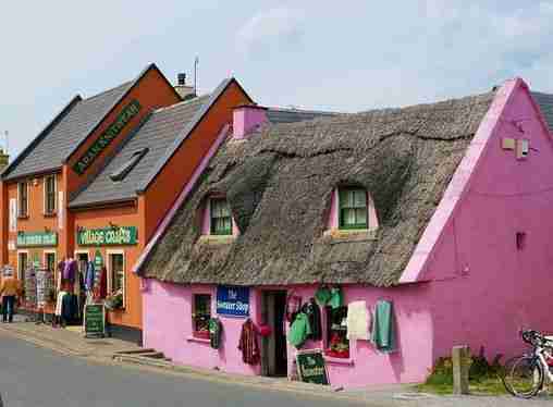
- Shop in the village, maybe purchase an authentic Aran island scarf or sweater
- Rent a bike and explore
- Book the mini-bus tour of the island
- Spend the day at the beach
- Enjoy the local cuisine
Aran Islands Map – Inis Mor (Inishmore)
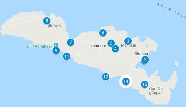
Download a PDF of the Aran Islands Map of Inis Mor Map HERE
Using the Aran Islands Map
Follow the numbered items on the map to visit the attractions and ruins in order. You can go to all the sites or some of the sites to create your own personal tour of Inis Mor Island. On the PDF, click on the map pins for additional information, images and videos of the attractions. The attractions guide below will list the Inis Mor attractions in sequential order for your personal easy to use tour of Inis Mor
A walk on Aran Islands showcasing the Aran Islands Attractions
Getting from Galway to Doolin (Rossaveal Port) to take the Aran Islands Ferry
Ferries can be taken to the Aran Islands from Rossaveal year round or from Doolin. The Doolin ferry is seasonal and weather dependent. It is longer to reach the islands from Doolin then Rossaveal. Tickets for Rossaveal can be purchased in Galway city with a 40 minute shuttle bus to Rossaveal. Doolin tickets can be purchased in Doolin Village and the harbour is a short walk from the village to the departure pier
- Galway to Aran Islands – Bus Eireann Route 424 provides regular services from Galway to Rossaveal ferry port. From Rossaveal, you can catch a ferry to the Aran Islands. Additional information can be found at the Aran Islands ferry website HERE
- Doolin to Aran Islands – Additional information as follows:
- There are several ferry companies providing tours to Cliffs of Moher, passage to Aran Islands or a combination of both:
Inis Mor (Inishmore)
At one point millions of years ago the Aran Islands were part of the mainland and therefore you will see some continuation of the Burren landscape. Inis Moris the largest and most popular of the three islands. During tourist season, arrival at the port at Inis Mor coincides with the a line of tourist mini buses to take you around the islands. Alternatively, you can rent a bike at the bike shop or walk to the attractions using the easy to follow map and attractions guide below
There are over 50 monuments and ruins and a population of about 1100 on Inis Mor. Most live in the village called Kilronan and like the other Aran islands, the village is part of Gaeltract, meaning the people preserve the language and speak Gaelic among themselves. They are fluent in English and will speak English with the tourists
Start of the Aran Islands Tour, Inis Mor Map and Self Guided Walking Tour (Items 1 – 17)
1 – 2. Inis Mor Pier & Kiloran
The ferry arrives at the port in Inis Mor close to the village of Kiloran (Cill Rónáin) which is the main settlement on the Inis Mor with a population of about 300
3. Aran Bike Hire
There are fewer than 100 cars on the island. Transportation is limited to mini-buses offering tourists tours or you can bike or go on foot. If you decide to rent bikes, the Aran bike hire is walking distance from the pier
4. Teampall Chiarian
St. Ciaran founded a monastery dating back to the 8/9th century. St Ciaran was in Aran studying under St Edna. There are many erect stone slabs that have crosses carved on them. One of these stone slabs has a hole on the top which may have been used for a sundial. It is located in the central part of the island near the village of Mainistir, near the coastal / upper road
Tobar Chiarian. St Ciarian’s Well. Locally referred to as Tobar (the well of the Salmon). The holy well is said to have produced huge salmon big enough to feed 150 monks
5. Dún Eochla
A circular prehistoric fort with a two terraced defensive wall system from the late Bronze Age. It is accessible from the main road and is south of the tiny village of Eochaill. The inner walls are 5m x 3m and are said to have been built between 550 and 800 AD. From the Dún Eochla stone ring fort you will have amazing views of at least five counties in Ireland: Kerry, Galway, Mayo, Clare, Limerick including the Cliffs of Moher. The old lighthouse (item 6 below) is close to the fort and on the way there you may see a wedge tomb which is between Dun Eocla and the Old Lighthouse
Getting to Dún Eochla
From the village of Kilronan proceed on Cottage Rd uphill past the village of Mainistir for 2.3 km. It is a 30 minute hike or 12 minute bike ride. On the way up you will pass the popular Joe Watty’s Bar, stop by for a pint before continuing
6. The Old Lighthouse
It is located on the highest point on the islands, close to Dún Eochla, 150 meters across the field. The lighthouse and associated signal tower were operational in the early 1800s. Unfortunately the lighthouse was not well positioned for ships in the Gregory Sound who could not see the lighthouse. It was eventually decommissioned and a new lighthouse was built
7. Eochail Church
It is a small parish church in the village of Eochaill with services on Saturdays
Teampall Asurnaí (St Sourney’s Church)
In the village of Eochaill is a small ruined church. You can access it by following the signs from the lower road (Bóthar ó Thuaidh). Not much is known about the church or its female patron Asurnaí. The tiny size of the church indicates that she was a small stature
8. Seal Colony Viewpoint
A nice view point on the way to Dun Aengus and close to Kilmrvey beach. A popular attraction on the island, however the seals are not always there and you have a beter chance of seeing them during low tide. Enjoy a picnic lunch and the view of Connemara in the background
9. Kilmurvey Beach
Kilmurvey is the other village on the island 7 km to the west of Kilronan and a 10 minute bike ride from the Seal Colony Viewpoint. The white sand blue flag beach is an oasis close to the village. It is surrounded by rocks, rolling green hills protecting the bay and is therefore not subject to the same strong currents elsewhere on the Island
10. Kilmurvey Village
The village is a known for its Celtic craft shops. Stop by the “Man of Aran Fudge” shop in Kimurvey Craft Village for a little pick-me-up and fabulous fudge. Near the village of Kilmurvey you will find the Monastery of Kilmurvey, St Colman’s Church, Church of the Saints, stone beehive huts, holy wells, burial sites marked with stone crosses
11. Na Seacht dTeampaill – The Seven Churches
West of the Harbour, it is one of the largest monastic foundations and a pilgrimage location rivalling that of St Edna on the eastern part of the island of Inishmore. Despite its name, the site consist of two churches: Teampall Bhreacain (begun in the 8th Century) and Teampall an Phoill (from the 15th Century). Onsite you will also find other buildings that were residences of the monks and also fragments of a high cross
Churches onsite:
- Teampall Bhreacain is the largest building and the main church on the site. Originally it was a small church that has undergone renovations as far back as the medieval times. The church can be identified by its impressive arch, chancel and nave. Nearby is the burial place, marked by a fragment of stone, of St. Breacan
- Teampall an Phoill referred to as the Church of the Hollow, it is a 15th century church south of Teampall Bhreacain
You may be able to spot the two holy wells Tobar an Spioraid Naoimh and Tobar Bhreacáin onsite which are now enclosed.
Irish apostles started the “Age of Saints and Scholars” movement in 500 – 900 AD and this site was a school of learning during Ireland’s golden age of literature and learning. St Edna’s is on the opposite end of the Island and was another site for learning and religious development
12. Dun Aengus (Dún Aonghasa)
A 2000 year old semicircular stone Fort that hangs precariously on the 100m cliff edge. The fort is enclosed by a six meter high defensive wall on the land side. It is though to have been built in the Bronze Age or Iron Age with the first construction going as far back as 1100BC and the defensive wall appears to have been built around 500 BC enclosing an area of approximately 14 acres 96 hectares)
Today it is perched 100m above sea level, however the seas at that time much lower during that time of construction and the fort may have been as high as 1000m above sea level There is evidence that some of the fort collapsed into the sea below. Recent restorations have restored the 6 meter defensive walls, chambers, walkways and stairs. The recent restoration is easy to spot as it uses mortar in the reconstruction where the original building technique was a dry stack method (no mortar/cement)
13 – 14. Poll na bPeist, The Worm Hole
The worm hole located south of Dun Aengus. You can access it by walking east along the cliff tops and following the signs for the village of Gort na gCapall. The “worm hole” is a rectangular shaped swimming hole that looks like a swimming pool. Naturally carved by the sea, it has become a popular cliff diving spot
15. Cliffs of Aran
The cliffs stretch right across the western part of the islands for 8 kilometers. There is a trail that takes you from sea level to the cliff tops and takes from 2 – 4 hours to complete. There are no safety railings or signs of caution. The cliff tops are rarely visited and you may find yourself among just a handful of tourists at the top enjoying the stunning views
16. Black Fort (Dun Duchatair)
The Black Fort gets its name from the black limestone in the area on the cliffs of Aran. The Fort is surrounded by some stone houses and is located on the Cill Éinne (Killeany) cliffs. Not as popular as Dun Aengus it is no less stunning. It is though to be built in the same time period as Dun Aengus with similar features such as its location on the cliff edge and its terraced defensive wall system. Excavations have not been completed and a more precise age is unknown
17. Tempall Bhean’in (St Benan’s Church)
St. Benan Church is on a hilltop overlooking Cill Éinne Bay.It dates back to the 7th century. It is the smallest church in all of Ireland. Nearby are stone ruins of a castle wall and stone cell
18. Teaghlach Einne (Church of St Enda)
One of the oldest monasteries in Ireland, “the household of Enda”, also called the Church of St Enda was established in the 8th century and is named after the 5th century monastery in the same area. It was a 6th century monastic school. The churches graveyard has 150 saints who are buried there and is still used today. Reportadly St Edna was buried under the altar of the church
The Other Aran Islands
Aran Island: Inis Meain
This is one of the least visited island with a population of 200 and has preserved the Irish culture. Monuments include Kilcanonagh Church, Church of the Kings Seven Sons and Dun Chonchubhair, an old oval stone fort. It is the most well preserved of the Aran Islands and the least changed allowing for a quiet peaceful escape to traditional life
Aran Island: Inisheer (Inis Oírr)
It is the smallest and most isolated of the three islands and it’s landscape closely resembles that of the Burren. Just 3km by 3km it has a number of hills and valleys you can explore by walking or biking. Ruins on the island suggest that it has been inhabited for 5000 years dating as far back as 1500BC
The hills have a number of ruins including:
- The old lighthouse – located on the highest point of the island. The 37 meter high tower opened in 1837
- Caisleán Uí Bhríain a 16th century 3 storey tower house built within a Stone Age fort
- Plassey – A shipwreck on the shores of Inisheer during a storm in 1960
- Temphall Chaomha – Church of St Keevauns, a Medieval church ruin and associated the graveyard
- Teampall Beag – The Small Church named after St. Gobnait dates back to the 10th century. The church is close to a number of beehive stone huts
- Cnoc Raithni is a prehistoric monastic site. It is a stone mound believed to be an ancient burial ground dated as far back as 1500BC
- On the north Shore you will find views out to Connemera and on the east shore there are great views of the Burren and Cliffs of Moher
There is a sandy white beach next to the village, in the village and you will find pubs with traditional music, an arts center and people with a strong sense of community
Getting from Dublin to Galway Ireland
- You can get to Galway by Irish rail from Dublin’s Heuston station or by bus using Gobus.ie. Aside from car rental, these are great routes for getting to Galway from Dublin.
- You can also use Bus Éireann instead of Gobus.ie. Use the journey planner for public transportation. In the planner, select Dublin station to Galway station for the different options
- The journey planner is for all of Irelands public transportation (not Gobus.ie as its privately operated). The planner will give you rail and bus options or a combination for travel in Ireland
Other Attractions in Ireland
Use the Getting around Ireland guide to visit Over 100 Attractions in Ireland (including Game of Thrones sites) or The Glens of Antrim
Additional Ireland Attraction Guides:
- Getting around Ireland – Using Public Transportation in Ireland
- Cliffs of Moher – A very popular tour, a complete guide to the 16 attractions along the Cliffs of Moher Coastal Walk
- Doolin – A quaint popular village in County Clare. Stop overnight and walk to the Cliffs of Moher from Doolin or enjoy the many other attractions in and around Doolin
- The Ring of Kerry – A spectacular 111 mile scenic route on the Iveragh Peninsula. Start at either Kenmare or Killarney for a circular route of three hours without stops. Jaw dropping views of the Atlantic ocean, charming villages and wild sweeping mountains makes this a popular must see attraction in Ireland. Use the map and attractions for the complete self guided tour of the Ring of Kerry
- The Dingle Peninsula – It is a 30 mile long clockwise loop that takes about 4 hours to complete. The area is the bedrock of Irish culture with signs in many villages and towns indicating that Irish is the predominant language in the area. The picturesque landscape includes rolling hills, craggy shorelines and sandy beaches. The PDF map and attractions guide explores the attractions of the Dingle Peninsula
- The Ring of Beara – An 85 mile circular route, similar to Ring of Kerry and Dingle Peninsula, however it is far less travelled. In that sense, it is a better drive as there are far less cars on the road. I found the Ring of Beara far more dramatic than either the Ring of Kerry or the Dingle Peninsula. It is not as popular because the tourist buses are not able to navigate the narrow roads with hairpin bends or the Healey Pass.
- Dublin: Explore central Dublin on foot with these three self guided walking tours and map:
- Dublin Walk 1 – Top 18 Attractions, guide to Dublin City Center, North of the River Liffey Dublin
- Dublin Walk 2 – Top 16 attractions, guide to attractions South of the River Liffey, including the Temple Bar Region
- The Book of Kells and Trinity College in Dublin. Trinity College is the oldest university in Ireland with the historic Long Room,and the old library with over 200,000 of the very old books. It is the most impressive library in the world
- In Dublin visit the Little Museum of Dublin, Grafton Street, St Stephens Green and Kilmainham Goal (the prison where many rebels from the Easter Rising were held before their execution)
- Dublin Walk 3 – Top 16 attractions, guide to Historic Old Dublin
- Galway – Use the Galway Ireland guide for a flexible and personal tour of over 40 attractions Galway City
- Aran Islands – For a truly authentic Irish experience visit the Aran Islands. They are located at the mouth of Galway Bay. You can catch a ferry from either Doolin or Rosseeval port (Shuttle from Galway to Rosseeval ferry port)
- The Glens of Antrim – Driving route for the nine Glens of Antrim in Northern Ireland. The guide includes options for public transportation, walking trails in The Glens and Game of Thrones Attractions
- Over 100 Northern Ireland Attractions – Visit over 100 attractions along the east and north coast of Ireland along the Antrim and Causeway Coastal Route. Travel by car or public transport from the Mourne Mountains to Londonderry. Includes game of thrones sites, castles and walks along the route
- The Burren – Explore the karst moonscape bedrock of The Burren located in the southwest region and close to the Cliffs of Moher. Attractions in the Burren include ancient tombs, underground caves, walks on an unusual landscape and The Burren National Park