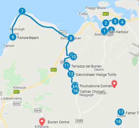
Burren Ireland Map and Self Guided Walking Tour
Use the Burren Ireland map below to visit the attractions in the Burren Region. A complete guide to attractions in the Burren Towers including caves, ancient tombs, abbeys, karst landscape hikes. Follow the walking route to explore the Burren region of Ireland at your own place. Spend a few hours or a full day depending on how long you want to spend at each attraction. Click on the arrow icon to the left of the title to display the legend. Click on the Burren Ireland attractions map pins (green pins) or on the legend (left icon on the title bar) or the PDF map that you download for additional information including images of the attraction
Getting to Burren National Park
Please note that you can drive to the Burren, take the Shuttle bus from Corofin or rent a bike to visit the Burren . A free shuttle bus from the village of Corofin to the Burren National Park runs 15 times a day 7 days a week during peak tourist season. In the park, there is an information panel indicating the location of several marked trails
For Burren Ireland Map accompanying attractions guide click HERE
Instructions to download the Interactive Burren Ireland Map to your smartphone is at the end of the post. Click on the map pins for additional information, images and/or videos
To download the PDF of the Burren Ireland map click HERE
Doolin to Corofin by bus, refer to the Burren Ireland map above
It will take about 3 hours on Bus #350 to junction N85/R476. At the junction catch bus #333 to Corofin. Make sure taking buses that head in the right direction towards Corofin. In Corofin take the free shuttle bus to Burren National Park Trailhead (the trailhead is the start of several marked trails in the park). Click on the orange map pin on the Burren Ireland map for the google location
The Burren National Park Shuttle Bus from Corofin
Please note that you can drive to the Burren, take the Shuttle bus from Corofin or rent a bike to visit the Burren. A free shuttle bus from the village of Corofin to the Burren National Park runs 15 times a day 7 days a week during peak tourist season. In the park, there is an information panel indicating the location of several marked trails. The Burren Information center is marked in orange on the Burren Ireland Map
The Burren Center in Kilfenora
The Burren Center in Kilfenora is a local co-operative dedicated to bringing local flora, archaeology, geology and legends in the Burren to life
Doolin to Kilfenora
From Doolin, take bus #350 to Lanhinch. From Lahinch take bus #333 to Kilfenora. All
together it will take you a little over an hour on the bus to the Burren visitor center
in Kilfenora
The Holy Wells, the well is marked as orange map pins on the Burren Ireland Map
There are hundreds of Holy Wells in Ireland and about 17 holy wells in mid-County Clare. The Irish word for well is ‘Tobar’ so if you see a sign with the a name that ends in ‘tubber’ such as Baile an Tobair or Ballintubber, most likely the location is associated with a holy well. They are supposed to have supernatural powers to cure ailments of the body and mind including eyes, infertility, and mental illness
The holy wells had three distinct features: they contained divine water, a blessed tree to spirit away the ailment and a stone with magical properties. Some of the well openings are shaped like an eye, presumably specializing in curing eye ailments. The wells were a spot for gathering and socialization as well as for offerings. A feast of the saint to whom the well was dedicated was celebrated on feast day. Though the pagan ritual has almost disappeared, it has had a revival in both protestant and catholic religions. Holy worship is an attraction for both locals and tourists at St Brigid’s Well near the Cliffs of Moher
The Burren Flora
The Burren grows plant and flower species from around the world. It is a fertile landscape and in only place in Europe where Mediterranean and Artic alpine plants grow alongside each other. You will also find 70% of Ireland’s flora in the Burren. Interestingly this rock garden is always in bloom as the plants bloom and rotate with the seasons
The Burren Fauna
The most common mammals in the Burren are feral goats, hares, badgers, voles, minks
and foxes. It is where seven of Ireland’s native bat species reside and due to its limestone base allowing for shell building you will also find over seventy species of snails. The Burren has an extensive butterfly community and in the summer you will see them fluttering past you. It is also home to over 100 bird species and a great place to hear the call of the cuckoo
The Burren Perfumery, the location is on the Burren Ireland map as an orange map pin
It’s hard to image that the bleak rocky landscape of The Burren grows over 70% of Ireland’s flora and is rated in the top 50 botanical sites in the world. This makes it the ideal location for a perfume manufacturing facility given the close proximity to natural ingredients. The Burren Perfume house opened over 40 years ago selling perfumes, oils, lotions, creams and lip balm. Onsite is a garden, tea house and gift shop
The Burren Safety
- The Burren has blocks of limestones separated by fissures called grykes. The grykes can be deep and it’s easy to twist your foot in them. Be careful when walking
- Ticks are found in the woodlands, moorlands and grassy area. There are ticks in the Burren. Lyme disease is a bacterial infection passed onto humans through tick bites.
- Avoid tick bites in The Burren:
- walk in the middle of the trails and avoiding overgrown vegetation
- have proper shoes not opened toes, sandals or bare feet
- tuck your trousers into your hiking boots or shoes
- use insect repellent with DEET (unpleasant– follow application guide)
- check yourself (and pets) out at the end of the day for ticks, check both skin and hair. Ticks like moist environments like armpits, neck, scalp, back of knees
- If you find a tick, remove it with tweezers and wash the area (make sure you get the entire tick out.
- If you get a tick bite, symptoms develop within 3 -30 days including rash, fevers, chills headaches, stiff neck, fatigue and joint pain
Click on the Burren Ireland Map Image for the Burren Ireland Region Attractions Guide to the map
Additional Ireland Attraction Guides:
- Getting around Ireland – Using Public Transportation in Ireland
- Cliffs of Moher – A very popular tour, a complete guide to the 16 attractions along the Cliffs of Moher Coastal Walk
- Doolin – A quaint popular village in County Clare. Stop overnight and walk to the Cliffs of Moher from Doolin or enjoy the many other attractions in and around Doolin
- The Ring of Kerry – A spectacular 111 mile scenic route on the Iveragh Peninsula. Start at either Kenmare or Killarney for a circular route of three hours without stops. Jaw dropping views of the Atlantic ocean, charming villages and wild sweeping mountains makes this a popular must see attraction in Ireland. Use the map and attractions for the complete self guided tour of the Ring of Kerry
- The Dingle Peninsula – It is a 30 mile long clockwise loop that takes about 4 hours to complete. The area is the bedrock of Irish culture with signs in many villages and towns indicating that Irish is the predominant language in the area. The picturesque landscape includes rolling hills, craggy shorelines and sandy beaches. The PDF map and attractions guide explores the attractions of the Dingle Peninsula
- The Ring of Beara – An 85 mile circular route, similar to Ring of Kerry and Dingle Peninsula, however it is far less travelled. In that sense, it is a better drive as there are far less cars on the road. I found the Ring of Beara far more dramatic than either the Ring of Kerry or the Dingle Peninsula. It is not as popular because the tourist buses are not able to navigate the narrow roads with hairpin bends or the Healey Pass.
- Dublin: Explore central Dublin on foot with these three self guided walking tours and map:
- Dublin Walk 1 – Top 18 Attractions, guide to Dublin City Center, North of the River Liffey Dublin
- Dublin Walk 2 – Top 16 attractions, guide to attractions South of the River Liffey, including the Temple Bar Region
- The Book of Kells and Trinity College in Dublin. Trinity College is the oldest university in Ireland with the historic Long Room,and the old library with over 200,000 of the very old books. It is the most impressive library in the world
- In Dublin visit the Little Museum of Dublin, Grafton Street, St Stephens Green and Kilmainham Goal (the prison where many rebels from the Easter Rising were held before their execution)
- Dublin Walk 3 – Top 16 attractions, guide to Historic Old Dublin
- Galway – Use the Galway Ireland guide for a flexible and personal tour of over 40 attractions Galway City
- Aran Islands – For a truly authentic Irish experience visit the Aran Islands. They are located at the mouth of Galway Bay. You can catch a ferry from either Doolin or Rosseeval port (Shuttle from Galway to Rosseeval ferry port)
- The Glens of Antrim – Driving route for the nine Glens of Antrim in Northern Ireland. The guide includes options for public transportation, walking trails in The Glens and Game of Thrones Attractions
- Over 100 Northern Ireland Attractions – Visit over 100 attractions along the east and north coast of Ireland along the Antrim and Causeway Coastal Route. Travel by car or public transport from the Mourne Mountains to Londonderry. Includes game of thrones sites, castles and walks along the route
- The Burren – Explore the karst moonscape bedrock of The Burren located in the southwest region and close to the Cliffs of Moher. Attractions in the Burren include ancient tombs, underground caves, walks on an unusual landscape and The Burren National Park
Instructions to download the interactive map to a smart phone:
Take the Map with you when you travel:
Instructions on:
- Using it offline
- Using it online – We bring one of our older smart phones when we travel and buy a local SIM card. You can purchase a local tourist SIM card from one of the main local providers, they are usually pretty inexpensive. You may need your passport to purchase as its a tourist SIM if you are an international tourist. You should have them put it in your old smartphone and check that it works before leaving the store. Use it to follow the map online, its the best way to explore
Sign into google using your Gmail account on your smart phone and be connected to the internet. If you do not sign in, this process will not work. You will be downloading this map to save it. You will be saving it in google maps in two places:
- Save in “Your Places” for online use and
- Save in “Offline map” for offline use
- Youtube instructions on link as follows:
https://youtu.be/_6j9koieMsU
Instructions to save above map:
- Click on the rectangle on the top right hand side of the above map [ ] – if you move your mouse to it, it will say “view larger map”
- It will take you into google maps on your smartphone and it will automatically save this map. You must be already be signed into google maps with your Gmail account, if you are not signed into google maps then the map will not be saved
- In google maps, click on the menu which is the three horizontal lines on the top left of the google map (it is to the left of the search box)
- From the menu, click on “Your Places”. This will take you to another screen with a menu at the top. From the top menu bar select “maps”. A list of your maps will be displayed including the map that was just saved. Select the map you just saved
- Make sure the map is still onscreen; do not close out of it as you will be downloading this map and it has to be onscreen to download. While the map is onscreen, click on menu again (three horizontal lines top left hand corner)
- Select “Offline maps” then select “custom map”
- Once you select “custom map”, the onscreen map will be displayed; select the area you want downloaded (zoom in or out to get all the data points into the blue square outline; pinch fingers for zooming)
- Click on “download” – this will save the map in an offline area that you can use when you are not connected to the internet
The map is now saved in two places. To see this, click on the menu (three horizontal line on top right hand corner) in google maps:
- Click on “Your Places” from the menu, then select “Custom Map”. The map will be listed and you can use the map while connected to the internet
- Click on “Offline Maps” from the menu. The map will be listed to use the map offline ie: not connected to the internet (make sure location services is turned on and your will see the blue dot indicating your location as you navigate with the offline map)
- After you download a map, use the Google Maps app just like you normally would. If your Internet connection is slow or absent, or if you are in “airplane mode” Google Maps will automatically use your offline maps to give you directions