Self Guided Walking Tour and Doolin Ireland Map of Things to do
Download the Doolin Map and use the Attractions Guide to visit the top sites
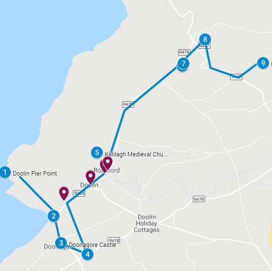
Use the Doolin attractions map below and the walking tour attractions guide for top things to do. A complete guide to viewing sites, parking entrance, and walking routes. Follow the walking route to explore Doolin attractions at your own pace and spend a few hours or a full day at each of the Top Doolin Attractions. Choose the attractions based on your personal preference to create your own private tour. Click on the arrow icon to the left of the title to display the legend with additional information, images and videos. Click on the attractions map pins (blue pins) on the interactive Doolin Ireland Map below, or on the legend or the PDF Doolin Ireland tourist map that you download for additional information including images of the attractions
Accompanying attractions guide is HERE
Instructions to download the Interactive Doolin Ireland map to a smartphone are at the end of the post. Click on the map pins for additional information, images and/or videos.
This post contains affiliate links. That means that I may earn a commission if you make a purchase though one of these links.
To download the PDF of the Doolin Ireland Map click HERE
Getting Around Doolin
Doolin is an authentic Irish village and you can walk to most of the attractions. Stay in the village and visit the neighboring attractions including the Burren National Park and associated ruins, take the Cliffs of Moher Walk and take the ferry to the Aran Islands. The many pubs in the village offer authentic live Irish music, don’t be surprised if people get up and start impromptu dancing!
Day Tour
The Cliffs of Moher, Kilmacduagh Abbey & Galway Day Tour is a very popular tour to book. popular tours to book in the area. It includes a stop at the unique landscape of the Burren, an usual rock formation covering 530 sqkm and some say resembles that of the surface of the moon..
Doolin Bus Service
The main bus stop in Doolin is outside the Hostel, which also functions as a ticket office for Bus Eireann. Bus Eireann #350 services Doolin and surrounding areas. You can take Bus #350 to, the Cliffs of Moher Visitor Car Gate, the Burren, and Ballyvaughan
Bustops include (Doolin to Galway, Doolin to Dublin):
Galway, Dublin Rd, Oranmore, Clarenbridge, Kilcolgan, Ballinderreen, Kinvara, New Quay, Bellharbour, Ballyvaughan, Blackhead Lighthouse, Munough Bridge, Fanore Cross, Ballinalacken Castle, Lisdoonvarna, Doolin, Cliffs of Moher, Liscannor, Lahinch, Ennistymon, Corofin Cross, Inagh, O Neills Cross, Fountain Cross, Ennis
From Galway Eyres Square you can get buses to Dublin and Dublin airport
From Ennis you can catch Bus Eireann #51 to Shannon airport, to Cork, Limerick or Killarney
Shopping in Doolin
There are a number of boutique and craft stores in Doolin showcasing the Irish craftsmanship. You will find gifts, sweaters, scarves, gourmet foods and textiles
Farmers Market
Ennistymon hosts a farmers market every Tuesday, this traditions goes back centuries. On Saturdays Ballyvaughan has a farmers market with a variety of local produce. A list of Farmers market in County Clare is listed HERE
- On Bus Eireann #350 it is 30 min Ennistymon or 1 hour to Ballyvaughan
Doolin Cruise to Cliffs of Moher
The cruise to the Cliffs of Moher usually take one hour and a guide points out the attractions along the 6-kilometer coastline. View the cliffs from sea level looking up 200 meters to the top of the cliffs. View the Branaunmore sea stack up close and if you are lucky you may see the resident bottlenose Dolphin, Dusty. In the area are other sights such as seals, sharks or whales who come to feed on the plankton beneath the Cliffs of Moher
Additional Tours and Activities in the area
Check out the following tours in the areas including Aran Islands, Galway and Cliffs of Mohr Cruises
Sea kayaking
Take a kayaking trip from Ballyvaughan to Gleninagh Castle and view the amazing Burren landscape from the sea. The North Clare Sea Kayaking company offers other trips such as cave tours and sunset trips. The cost includes equipment rental including wet suits
Doolin To Aran Islands
The journey is about 25 min – 1.5 hours depending on which island you are going to. You cannot take your car across to the Aran Islands as there are no car ferries available to the island. However there is lots to do on the Aran Islands including:
- Explore the ruins of the islands
- Take one of the many walks along the coast or the cliffs
- Shop in the village, maybe purchase an authentic Aran island scarf or sweater
- Rent a bike and explore
- Book the mini-bus tour of the island
- Spend the day at the beach
- Enjoy the local cuisine
How Long Should You Spend In Doolin?
There are a variety of activities around Doolin. If you want to base yourself in Doolin and explore the Burren, Cliffs of Moher, Aran islands and pursue outdoor activities such as kayaking, wind surfing, hiking or horseback riding you could easily spend a few days to a week in the area
Click HERE for Doolin Ireland Attractions guide
Additional Attraction in Ireland:
- Getting around Ireland – Using Public Transportation in Ireland
- Cliffs of Moher – A very popular tour, a complete guide to the 16 attractions along the Cliffs of Moher Coastal Walk
- Doolin – A quaint popular village in County Clare. Stop overnight and walk to the Cliffs of Moher from Doolin or enjoy the many other attractions in and around Doolin
- The Ring of Kerry – A spectacular 111 mile scenic route on the Iveragh Peninsula. Start at either Kenmare or Killarney for a circular route of three hours without stops. Jaw dropping views of the Atlantic ocean, charming villages and wild sweeping mountains makes this a popular must see attraction in Ireland. Use the map and attractions for the complete self guided tour of the Ring of Kerry
- The Dingle Peninsula – It is a 30 mile long clockwise loop that takes about 4 hours to complete. The area is the bedrock of Irish culture with signs in many villages and towns indicating that Irish is the predominant language in the area. The picturesque landscape includes rolling hills, craggy shorelines and sandy beaches. The PDF map and attractions guide explores the attractions of the Dingle Peninsula
- The Ring of Beara – An 85 mile circular route, similar to Ring of Kerry and Dingle Peninsula, however it is far less travelled. In that sense, it is a better drive as there are far less cars on the road. I found the Ring of Beara far more dramatic than either the Ring of Kerry or the Dingle Peninsula. It is not as popular because the tourist buses are not able to navigate the narrow roads with hairpin bends or the Healey Pass.
- Dublin: Explore central Dublin on foot with these three self guided walking tours and map:
- Dublin Walk 1 – Top 18 Attractions, guide to Dublin City Center, North of the River Liffey Dublin
- Dublin Walk 2 – Top 16 attractions, guide to attractions South of the River Liffey, including the Temple Bar Region
- The Book of Kells and Trinity College in Dublin. Trinity College is the oldest university in Ireland with the historic Long Room,and the old library with over 200,000 of the very old books. It is the most impressive library in the world
- In Dublin visit the Little Museum of Dublin, Grafton Street, St Stephens Green and Kilmainham Goal (the prison where many rebels from the Easter Rising were held before their execution)
- Dublin Walk 3 – Top 16 attractions, guide to Historic Old Dublin
- Galway – Use the Galway Ireland guide for a flexible and personal tour of over 40 attractions Galway City
- Aran Islands – For a truly authentic Irish experience visit the Aran Islands. They are located at the mouth of Galway Bay. You can catch a ferry from either Doolin or Rosseeval port (Shuttle from Galway to Rosseeval ferry port)
- The Glens of Antrim – Driving route for the nine Glens of Antrim in Northern Ireland. The guide includes options for public transportation, walking trails in The Glens and Game of Thrones Attractions
- Over 100 Northern Ireland Attractions – Visit over 100 attractions along the east and north coast of Ireland along the Antrim and Causeway Coastal Route. Travel by car or public transport from the Mourne Mountains to Londonderry. Includes game of thrones sites, castles and walks along the route
- The Burren – Explore the karst moonscape bedrock of The Burren located in the southwest region and close to the Cliffs of Moher. Attractions in the Burren include ancient tombs, underground caves, walks on an unusual landscape and The Burren National Park
Instructions to download the interactive map to a smart phone:
Take the Map with you when you travel:
Instructions on:
- Using it offline
- Using it online – We bring one of our older smart phones when we travel and buy a local SIM card. You can purchase a local tourist SIM card from one of the main local providers, they are usually pretty inexpensive. You may need your passport to purchase as its a tourist SIM if you are an international tourist. You should have them put it in your old smartphone and check that it works before leaving the store. Use it to follow the map online, its the best way to explore
Sign into google using your Gmail account on your smart phone and be connected to the internet. If you do not sign in, this process will not work. You will be downloading this map to save it. You will be saving it in google maps in two places:
- Save in “Your Places” for online use and
- Save in “Offline map” for offline use
- Youtube instructions on link as follows:
https://youtu.be/_6j9koieMsU
Instructions to save above map:
- Click on the rectangle on the top right hand side of the above map [ ] – if you move your mouse to it, it will say “view larger map”
- It will take you into google maps on your smartphone and it will automatically save this map. You must be already be signed into google maps with your Gmail account, if you are not signed into google maps then the map will not be saved
- In google maps, click on the menu which is the three horizontal lines on the top left of the google map (it is to the left of the search box)
- From the menu, click on “Your Places”. This will take you to another screen with a menu at the top. From the top menu bar select “maps”. A list of your maps will be displayed including the map that was just saved. Select the map you just saved
- Make sure the map is still onscreen; do not close out of it as you will be downloading this map and it has to be onscreen to download. While the map is onscreen, click on menu again (three horizontal lines top left hand corner)
- Select “Offline maps” then select “custom map”
- Once you select “custom map”, the onscreen map will be displayed; select the area you want downloaded (zoom in or out to get all the data points into the blue square outline; pinch fingers for zooming)
- Click on “download” – this will save the map in an offline area that you can use when you are not connected to the internet
The map is now saved in two places. To see this, click on the menu (three horizontal line on top right hand corner) in google maps:
- Click on “Your Places” from the menu, then select “Custom Map”. The map will be listed and you can use the map while connected to the internet
- Click on “Offline Maps” from the menu. The map will be listed to use the map offline ie: not connected to the internet (make sure location services is turned on and your will see the blue dot indicating your location as you navigate with the offline map)
- After you download a map, use the Google Maps app just like you normally would. If your Internet connection is slow or absent, or if you are in “airplane mode” Google Maps will automatically use your offline maps to give you directions